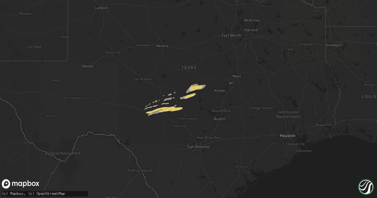
Hail Map on February 28, 2018
Get this storm
February 28 map
$229
one time, instant access
Download today. No call, no setup
Keep the $229
Bought the map and want the full workflow? Apply the entire $229 to a subscription within 7 days. None of it is wasted.
Every map, not just this one
This buys you this map. Subscription and you get every map we run, in the markets you choose from a few cities to whole states to nationwide. Plus real-time alerts the moment a storm fires.
Contact data
Name, contact info, occupancy, even credit band for addresses in the footprint. You go from where it hit to who to call.
Become the source they trust
Unlimited branding weather history reports on demand. You already have the documented answer ready for the property owner, and you are the one who showed up with it.
Property data and RoofTrace estimates
Pull up any address you have got, its value and the exact code rules for that jurisdiction, straight from One Click Code. Then RoofTrace estimates the squares, pitch, and roof value, priced the way you price.
States Impacted by Hail Map on February 28, 2018
Storm reports
Louisiana
| Date | Description |
|---|---|
| 02/28/20183:07 AM CST | Trees down across the entire parish. |
| 02/28/20182:55 AM CST | Utility power pole snapped near longwood... La. |
Alabama
| Date | Description |
|---|---|
| 02/28/20184:50 PM CST | Damage to house and barn along pentacost road along the morgan-cullman line. Time estimated from radar. |
| 02/28/20184:48 PM CST | Porch and roof damage to a home along county road 1542. Time estimated from radar. |
| 02/28/20184:48 PM CST | Damage along county roads 1524 and 1526 near the cullman-morgan county line. Time estimated from radar. |
| 02/28/20184:06 PM CST | Large bay doors on a building were blown out. One light pole was blown down and a few cars had windows broken out. |
| 02/27/20189:05 PM CST | At 304 PM CST, a severe thunderstorm was located over Ashridge, or 7 miles east of Haleyville, moving east at 25 mph. HAZARD...60 mph wind gusts and nickel size hail. SOURCE...Radar indicated. IMPACT...Expect damage to roofs, siding, and trees. Locations impacted include... Haleyville, Double Springs, Needmore, Moreland, Ashridge, Winston Free State Barn, Weiss, Posey Field Airport, Pebble, Mill Creek, Delmar, Sipsey River Rec Area, Grayson and western Bankhead National Forest. |
| 02/27/20188:50 PM CST | At 250 PM CST, a severe thunderstorm was located over Detroit, or 10 miles north of Sulligent, moving east at 40 mph. HAZARD...60 mph wind gusts and nickel size hail. SOURCE...Radar indicated. IMPACT...Expect damage to roofs, siding, and trees. Locations impacted include... Hamilton, Detroit, Henson Springs, Byrd, Marion County Public Lake, Rankin Fite Airport and Pikeville. |
| 02/27/20188:48 PM CST | At 247 PM CST, a severe thunderstorm was located over Hamilton, moving east at 30 mph. HAZARD...60 mph wind gusts and nickel size hail. SOURCE...Radar indicated. IMPACT...Expect damage to roofs, siding, and trees. Locations impacted include... Hamilton, Hackleburg, Brinn, Bear Creek, Tessner and Upper Bear Creek Reservoir. |
| 02/27/20188:07 PM CST | At 206 PM CST, a severe thunderstorm was located near Weston, or 8 miles west of Hamilton, moving east at 30 mph. HAZARD...60 mph wind gusts. SOURCE...Radar indicated. IMPACT...Expect damage to roofs, siding, and trees. Locations impacted include... Hamilton, Hackleburg, Weston and Pearces Mill. |
Texas
| Date | Description |
|---|---|
| 02/28/20185:28 AM CST | At 1128 PM CST, a severe thunderstorm was located 8 miles north of Bend, or 14 miles east of San Saba, moving east at 45 mph. HAZARD...Quarter size hail. SOURCE...Radar indicated. IMPACT...Damage to vehicles is possible. This severe thunderstorm will remain over mainly rural areas of Lampasas County, including the following locations: Lometa. |
| 02/27/201811:11 PM CST | Public has reported and sent in pictures of roof damage and large trees uprooted 2 1/2 miles east of san saba. |
Arkansas
| Date | Description |
|---|---|
| 02/27/201810:37 PM CST | At 437 PM CST, a severe thunderstorm was located over Bearden, or 13 miles southwest of Fordyce, moving northeast at 55 mph. HAZARD...60 mph wind gusts and quarter size hail. SOURCE...Radar indicated. IMPACT...Hail damage to vehicles is expected. Expect wind damage to roofs, siding, and trees. Locations impacted include... Pine Bluff... Fordyce... Star City... Rison... Bearden... Kingsland... Thornton... Feenyville... Ellisville... Harlow... Hebron... Kedron... Highland Industrial Park... Mt Elba... Tipton... Marks Mill State Park... Toledo... Herbine... Sulphur Springs... Cornerville...This includes Interstate 530 near mile marker 39. |