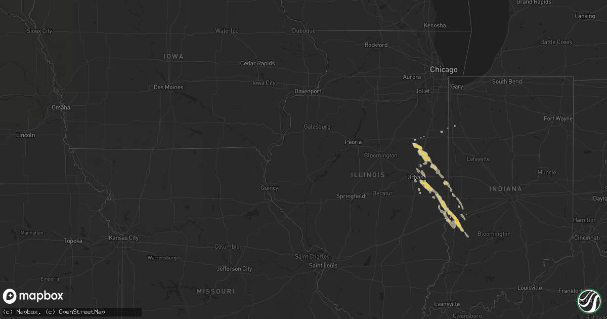
Hail Map on May 7, 2011
Get this storm
May 7 map
$229
one time, instant access
Download today. No call, no setup
Keep the $229
Bought the map and want the full workflow? Apply the entire $229 to a subscription within 7 days. None of it is wasted.
Every map, not just this one
This buys you this map. Subscription and you get every map we run, in the markets you choose from a few cities to whole states to nationwide. Plus real-time alerts the moment a storm fires.
Contact data
Name, contact info, occupancy, even credit band for addresses in the footprint. You go from where it hit to who to call.
Become the source they trust
Unlimited branding weather history reports on demand. You already have the documented answer ready for the property owner, and you are the one who showed up with it.
Property data and RoofTrace estimates
Pull up any address you have got, its value and the exact code rules for that jurisdiction, straight from One Click Code. Then RoofTrace estimates the squares, pitch, and roof value, priced the way you price.
States Impacted by Hail Map on May 7, 2011
Storm reports
Arkansas
| Date | Description |
|---|---|
| 05/07/20118:16 AM CDT | A local report indicates 1.00 inch wind near 4 E HEBER SPRINGS |
Illinois
| Date | Description |
|---|---|
| 05/07/20116:45 PM CDT | A local report indicates 1.00 inch wind near 2 W CHRISMAN |
| 05/07/20116:08 PM CDT | Several weak tornadoes |
| 05/07/20115:43 PM CDT | A local report indicates 1.00 inch wind near 3 S ST. JOSEPH |
| 05/07/20115:38 PM CDT | A local report indicates 1.50 inch wind near SIDNEY |
| 05/07/20115:32 PM CDT | A local report indicates 1.00 inch wind near SIDNEY |
| 05/07/20114:05 PM CDT | Preliminary report of a small tornado. Touch down was in open country. No damage reported. |
| 05/07/20114:00 PM CDT | A local report indicates 1.00 inch wind near LODA |
| 05/07/20113:15 PM CDT | A local report indicates 1.00 inch wind near 2 S CHATSWORTH |
| 05/06/20117:16 PM CDT | A local report indicates 1.00 inch wind near 6 E PARIS |
Indiana
| Date | Description |
|---|---|
| 05/07/20116:44 PM CDT | Also reported rotating wall cloud. |
| 05/07/20116:18 PM CDT | At falcon mart near highways 234 and 63. |
| 05/07/20114:55 PM CDT | A local report indicates 1.00 inch wind near 2 SW MOROCCO |
| 05/06/20117:45 PM CDT | At eaton dr. And mcdaniel rd. |
| 05/06/20117:39 PM CDT | A local report indicates 1.25 inch wind near TERRE HAUTE |
| 05/06/20117:35 PM CDT | Hole in the roof of the community theater in terre haute. Time estimated from radar. |
| 05/06/20117:35 PM CDT | Southern terre haute. |
| 05/06/20117:23 PM CDT | Pea to quarter sized hail covered the ground in shirkieville. |
| 05/06/20117:18 PM CDT | A local report indicates 1.00 inch wind near SANDFORD |
Cities Impacted by Hail Map on May 7, 2011
- Paris, IL
- Allerton, IL
- Sidney, IL
- Sidell, IL
- Broadlands, IL
- Urbana, IL
- Homer, IL
- West Terre Haute, IN
- Terre Haute, IN
- Loda, IL
- Rankin, IL
- Paxton, IL
- Danville, IL
- Westville, IL
- Georgetown, IL
- Gilman, IL
- Collison, IL
- Heber Springs, AR
- Drasco, AR
- Higden, AR
- Vanzant, MO
- Dora, MO
- Drury, MO
- Rantoul, IL
- Clinton, AR
- Hillsdale, IN
- Dana, IN
- Montezuma, IN
- Chatsworth, IL
- Piper City, IL
- Buckley, IL
- Roberts, IL
- Lewis, IN
- Pimento, IN
- Downey, ID
- Lava Hot Springs, ID
- Floral, AR
- Chrisman, IL
- Melvin, IL
- Gifford, IL
- Ludlow, IL
- Leslie, AR
- Champaign, IL
- Thomasboro, IL
- Morocco, IN
- Vermilion, IL
- Mitchell, SD
- Wilburn, AR
- Holliston, MA
- Ashland, MA
- Penfield, IL
- Gann Valley, SD
- Saint Joseph, IL
- Donovan, IL
- Watseka, IL
- Edgemont, AR
- Mountain View, AR
- Potomac, IL
- Armstrong, IL
- Cayuga, IN
- Cory, IN
- Brazil, IN
- Pangburn, AR
- Marshall, IL
- Farmersburg, IN
- Riley, IN
- Jasonville, IN
- Hume, IL
- Shelburn, IN
- Dennison, IL
- Metcalf, IL
- Rosedale, IN
- Menno, SD
- Judsonia, AR
- Linton, IN
- Worthington, IN
- Prim, AR
- Wessington Springs, SD
- Oakwood, IL
- Fithian, IL
- Tilton, IL
- Rockville, IN
- Hurley, SD
- Theodosia, MO
- Oakland, AR
- Peel, AR
- Amherst, NH
- Sherborn, MA
- Hopkinton, MA
- Hollis, NH
- Fox, AR
- Onarga, IL
- Kennebec, SD
- Fairfield Bay, AR
- Shirley, AR
- Savoy, IL
- Tolono, IL
- Perrysville, IN
- Philo, IL
- Villa Grove, IL