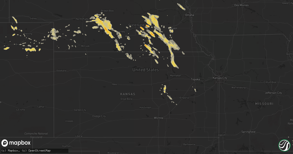
Hail Map on July 5, 2011
Get this storm
July 5 map
$229
one time, instant access
Download today. No call, no setup
Keep the $229
Bought the map and want the full workflow? Apply the entire $229 to a subscription within 7 days. None of it is wasted.
Every map, not just this one
This buys you this map. Subscription and you get every map we run, in the markets you choose from a few cities to whole states to nationwide. Plus real-time alerts the moment a storm fires.
Contact data
Name, contact info, occupancy, even credit band for addresses in the footprint. You go from where it hit to who to call.
Become the source they trust
Unlimited branding weather history reports on demand. You already have the documented answer ready for the property owner, and you are the one who showed up with it.
Property data and RoofTrace estimates
Pull up any address you have got, its value and the exact code rules for that jurisdiction, straight from One Click Code. Then RoofTrace estimates the squares, pitch, and roof value, priced the way you price.
States Impacted by Hail Map on July 5, 2011
Storm reports
South Carolina
| Date | Description |
|---|---|
| 07/05/20116:56 PM CDT | Sheriff dispatch reported a tree down along hwy 76 just outside of lynchburg. |
| 07/05/20115:22 PM CDT | Large limbs down across hwy 917 blocking road |
| 07/05/20115:05 PM CDT | Public reported several large limbs down at the hide-a-way campground on lake marion. On large limb fell down on a camper. |
| 07/05/20115:05 PM CDT | Public reported quarter size hail at the hide-a-way campground on lake marion. |
| 07/05/20114:39 PM CDT | Sc highway patrol reports one tree in the roadway near the intersection of e georgia road and howard drive. |
| 07/05/20114:08 PM CDT | Sc highway patrol reports one tree in the roadway near the intersection of east mountain creek road and mountain creek church road. |
| 07/05/20114:05 PM CDT | Highway patrol reports trees blown down on old williamston rd...on hwy 17 at hwy 86...and power lines down on mountain springs rd...all 2 to 4 wnw of piedmont. |
| 07/05/20114:05 PM CDT | Thunderstorm winds blew down a tree along hughes drive. Time was estimated from radar. |
| 07/05/20114:03 PM CDT | Thunderstorm winds blew down a tree along drew hill court. Time was estimated from radar. |
| 07/05/20114:00 PM CDT | The public reported quarter size hail near highway 52. |
| 07/05/20113:50 PM CDT | Estimate of 60 to 70 mph winds with nickel size hail |
| 07/05/20113:00 PM CDT | Sc highway patrol reports one tree in the roadway near the intersection of hw-288 and hw-276. |
Texas
| Date | Description |
|---|---|
| 07/05/20116:27 PM CDT | Part of the roof of a mobile home in pert was removed. Another part of the roof was partially lifted off. |
| 07/05/20115:38 PM CDT | 2 metal sheds with roof damage and trees down |
| 07/05/20115:26 PM CDT | Trees down in devers |
| 07/04/20117:25 PM CDT | Large pine tree down across fm 645 roughly 2-3 miles south of tennessee colony |
North Carolina
| Date | Description |
|---|---|
| 07/05/20116:20 PM CDT | Tree down on lake wheeler road |
| 07/05/20115:40 PM CDT | A few trees down at intersection of hwy 211 and webb faulk rd. |
| 07/05/20115:40 PM CDT | Power lines down |
| 07/05/20115:35 PM CDT | Branches and trees down on mutt griffin road. Marble sized hail. Relayed from media. |
| 07/04/20118:12 PM CDT | One tree fell on a vehicle near highway 581 and renfrow road |
| 07/04/20117:17 PM CDT | A few trees down at intersection of hwy 211 and webb faulk rd. |
Louisiana
| Date | Description |
|---|---|
| 07/05/20113:37 PM CDT | Chenault airpark asos reports gust to 58 knots or 67 mph. |
South Dakota
| Date | Description |
|---|---|
| 07/05/20113:05 PM CDT | A local report indicates 1.50 inch wind near 4 E DEERFIELD |
| 07/05/20112:40 PM CDT | A local report indicates 1.25 inch wind near 3 WNW ROCHFORD |
| 07/05/20112:05 PM CDT | A local report indicates 1.00 inch wind near WNW CHEYENNE CROSSING |
Kansas
| Date | Description |
|---|---|
| 07/04/201110:28 PM CDT | Law enforcement reports quarter sized hail. |
| 07/04/201110:13 PM CDT | A local report indicates 1.25 inch wind near SSE HOPE |
| 07/04/201110:08 PM CDT | A local report indicates 1.00 inch wind near ENE HOPE |
| 07/04/20118:12 PM CDT | A local report indicates 60 MPH wind near 2 WNW OLSBURG |
| 07/04/20118:00 PM CDT | A local report indicates 60 MPH wind near 2 W CORNING |
| 07/04/20117:37 PM CDT | A local report indicates 1.00 inch wind near 5 NE BREMEN |
| 07/04/20117:37 PM CDT | A local report indicates 60 MPH wind near 5 NE BREMEN |
Iowa
| Date | Description |
|---|---|
| 07/05/20116:15 PM CDT | Corn flattened by wind gust. |
| 07/05/20115:43 PM CDT | Large tree limbs and half a tree down at addresses 2128-2148 320th street. Corn partially flattened. |
| 07/05/20115:20 PM CDT | Hog building destroyed. Trees down. Windmill down. |
| 07/05/20115:20 PM CDT | Large limbs down northeast side of fort dodge. |
| 07/05/20115:19 PM CDT | Tree limbs down. |
| 07/05/20114:12 PM CDT | Maple tree in front yard with limbs broken in half. 8 to 10 inches in diameter. Power out. Other damage west of burt. From nssl shave project. |
| 07/05/20114:07 PM CDT | Power lines and trees down. From nssl shave project. |
| 07/05/20114:04 PM CDT | From nssl shave project. |
| 07/05/20113:22 PM CDT | Listener report relaied via klga. Telephone poles down...damage to building...possibily a trailer damaged too. |
| 07/05/20113:15 PM CDT | Some two to three inch diameter branches down. From nssl shave project. |
| 07/04/20117:05 PM CDT | One large 15 inch diameter tree limb blocking one lane. Several smaller 4 inch diameter tree limbs down. |
Wisconsin
| Date | Description |
|---|---|
| 07/05/20115:24 PM CDT | Trees and powerlines down in three lakes. |
| 07/05/20115:22 PM CDT | Corrected location from previous 10nw winter. |
| 07/05/20115:22 PM CDT | A local report indicates 1.25 inch wind near 10 NW WINTER |
| 07/05/20114:08 PM CDT | Small branches down with winds e50-60 mph. |
| 07/05/20114:06 PM CDT | Lasted 15 minutes and was 1-2 inches deep. E1.5 of rain. |
| 07/04/20118:45 PM CDT | Power out and 2-4 inch diameter tree branches down. County line road. |
| 07/04/20118:31 PM CDT | Tree down over larson drive near n2366. |
Wyoming
| Date | Description |
|---|---|
| 07/05/20116:56 PM CDT | Could hear hail roar to the south. |
| 07/05/20116:56 PM CDT | Could hear hail roar to the south. |
| 07/04/20119:30 PM CDT | A local report indicates 60 MPH wind near WRIGHT |
| 07/04/20119:15 PM CDT | Late report. Largest stones were up to ping pong ball size. |
| 07/04/20118:00 PM CDT | Lasted 5 minutes |
| 07/04/20117:57 PM CDT | Dime and quarters. |
| 07/04/20117:38 PM CDT | A local report indicates 3.00 inch wind near 10 NNW ROCHELLE |
Arizona
| Date | Description |
|---|---|
| 07/05/20116:59 PM CDT | Tucson international airport asos recorded a 70 mph wind gust. |
| 07/05/20116:58 PM CDT | Davis-monthan asos recorded a 72 mph wind gust. |
| 07/05/20115:00 PM CDT | From stanton raws station |
| 07/05/20112:30 AM CDT | Thunderstorm winds uprooted two large mesquite trees in rotary community park in lake havasu city. In addition numerous tree limbs were reported down and rough lake wat |
| 07/04/201110:30 PM CDT | Carport collapse. Mcclintock and ray. |
| 07/04/201110:03 PM CDT | Two twenty inch diameter trees fell on police station. |
| 07/04/201110:00 PM CDT | Semi truck blown over along interstate 8 at mile marker 169. |
| 07/04/20119:52 PM CDT | Report relayed to nws tree fell on house due to high winds in dust storm. |
| 07/04/20119:45 PM CDT | A local report indicates 59 MPH wind near 5 SSE TEMPE |
| 07/04/20119:40 PM CDT | Two twenty inch trees uprooted and fell on police station at gila river indian community. |
| 07/04/20119:40 PM CDT | 20 power polls down |
| 07/04/20119:32 PM CDT | Gilbert and riggs road. Several other reports of winds 50 to 65 mph. |
| 07/04/20119:20 PM CDT | Several downed trees... Along with roof damage... And brick walls blown over in saddlebrooke. |
| 07/04/20118:45 PM CDT | Tree fell on porch with partial roof damage. |
| 07/04/20118:10 PM CDT | Several eucalyptus tree limbs down. |
| 07/04/20118:10 PM CDT | Mesquite tree snapped at the base due to thunderstorm winds. Also multiple tree limbs down in the area. |
| 07/04/20118:00 PM CDT | Small trees uprooted. |
| 07/04/20118:00 PM CDT | Twenty foot section of a brick wall blown down. |
| 07/04/20117:10 PM CDT | Part of roof blown off and into backyard |
| 07/04/20117:10 PM CDT | A local report indicates 58 MPH wind near TUCSON |
| 07/04/20117:01 PM CDT | Spotter reports awning off business at e ajo way and s dodge blvd. |
Nebraska
| Date | Description |
|---|---|
| 07/05/20116:57 PM CDT | A local report indicates 1.75 inch wind near 1 W FAIRMONT |
| 07/05/20116:55 PM CDT | A local report indicates 64 MPH wind near 2 N BEATRICE |
| 07/05/20116:44 PM CDT | Measured wind gust. |
| 07/05/20116:40 PM CDT | A local report indicates 60 MPH wind near 4 NE HALLAM |
| 07/05/20116:25 PM CDT | A local report indicates 60 MPH wind near 1 W WESTERN |
| 07/05/20116:05 PM CDT | A local report indicates 1.75 inch wind near 7 NE GILTNER |
| 07/05/20116:00 PM CDT | Measured wind gust. |
| 07/05/20115:53 PM CDT | Quarter size hail with 50 to 60 mile per hour winds estimated. |
| 07/05/20115:47 PM CDT | Quarter to golf ball size hail. |
| 07/05/20115:40 PM CDT | A local report indicates 1.00 inch wind near 4 NW BEAVER CROSSING |
| 07/05/20115:34 PM CDT | A large limb fell on garage resulting in roof damage. |
| 07/05/20115:27 PM CDT | A local report indicates 60 MPH wind near 3 S WACO |
| 07/05/20115:25 PM CDT | Half inch also. |
| 07/05/20115:25 PM CDT | Moderate tree damage in the town of waco. Many tree branches down with some a foot in diameter or bigger. |
| 07/05/20115:20 PM CDT | Estimated wind speeds of 60 to 70 mph around 515 pm. Numerous tree limbs up to 6 inches in diamter broken. |
| 07/05/20115:15 PM CDT | Estimated wind speeds of 60 to 70 mph around 515 pm. Numerous tree limbs up to 6 inches in diamter broken. |
| 07/05/20114:58 PM CDT | Estimated 60 mile per hour wind with thunderstorm and heavy rain. Visibility has been reduced to about a block. |
| 07/05/20114:35 PM CDT | A local report indicates 1.50 inch wind near OSCEOLA |
| 07/05/20114:31 PM CDT | A local report indicates 1.50 inch wind near OSCEOLA |
| 07/05/20114:26 PM CDT | A local report indicates 1.00 inch wind near OSCEOLA |
| 07/05/20114:23 PM CDT | Nickel size hail |
| 07/04/201111:10 PM CDT | Coop observer estimated wind gusts up to 70 mph. Power is out in imperial. |
| 07/04/201110:44 PM CDT | 60 to 70 mile per hour winds with very heavy rainfall. |
| 07/04/201110:39 PM CDT | A local report indicates 58 MPH wind near BENKELMAN |
| 07/04/201110:32 PM CDT | A local report indicates 1.25 inch wind near 10 S OVERTON |
| 07/04/201110:30 PM CDT | Hail covering highway 23 between bertrand and loomis. Hail size up to ping pong balls. |
| 07/04/201110:20 PM CDT | Delayed reports of storm damage from the evening of july 5th. High winds caused tree branches to blow down onto power lines and caused power outages in imperial. Large |
| 07/04/201110:19 PM CDT | Hail covering the road just south of overton interchange. Largest hail size is half dollar to ping pong balls. |
| 07/04/201110:04 PM CDT | A local report indicates 1.25 inch wind near 4 W OVERTON |
| 07/04/20119:58 PM CDT | 60 to 70 mile per hour winds in overton. Very heavy rain and small branches down. |
| 07/04/20119:42 PM CDT | A local report indicates 60 MPH wind near 2 E COZAD |
| 07/04/20119:38 PM CDT | Golf ball size hail lasted for approximately 1 to 2 minutes. |
| 07/04/20119:31 PM CDT | A local report indicates 1.00 inch wind near 16 WSW GRANT |
| 07/04/20119:05 PM CDT | Sparce hail a few ping pong size. |
| 07/04/20118:09 PM CDT | A local report indicates 1.00 inch wind near CHESTER |
| 07/04/20118:08 PM CDT | A local report indicates 1.00 inch wind near CHESTER |
| 07/04/20117:47 PM CDT | A local report indicates 70 MPH wind near 2 S BURCHARD |
| 07/04/20117:37 PM CDT | Pea to quarter size hail. |
| 07/04/20117:31 PM CDT | A local report indicates 1.00 inch wind near 6 E CLAY CENTER |
| 07/04/20117:15 PM CDT | Trees and power lines blown down. Numerous power outages. |
| 07/04/20117:05 PM CDT | Trees blown down blocking roadway. |
| 07/04/20117:03 PM CDT | Most of the hail was smaller than quarters...but some quarter size hail. Rainfall of 0.40 in about 10 minutes. |
| 07/04/20117:00 PM CDT | Golf ball size hail for approximately a 30 minute period. Crop damage was reported from oak to ruskin in a 4 mile wide path. |
Arkansas
| Date | Description |
|---|---|
| 07/05/20116:25 PM CDT | Large tree down blocking the southbound lane of hwy 53 just south of lewisville |
| 07/05/20116:20 PM CDT | Large tree down blocking the southbound lane of hwy 53 just south of lewisville |
| 07/05/20115:40 PM CDT | The roof was damaged...brick pillars collapsed...and a stained glass window was shattered at the highland hills baptist church on highway 82 on the east side of texarka |
| 07/05/20115:35 PM CDT | Large limbs down across highway 53 in the bodcaw community. |
| 07/05/20115:15 PM CDT | Trees and power lines down on north pine street and large tree down at the intersection of egdewood and third streets |
| 07/05/20114:15 PM CDT | A few trees were uprooted near nashville. Numerous large limbs were downed as well. |
| 07/05/20114:15 PM CDT | Quarter size hail fell in nashville. |
| 07/05/20112:22 PM CDT | Trees and power lines were reported down between mount ida and story. |
| 07/05/201110:39 AM CDT | Public reported that a tree was blown down along hwy 167. |
Montana
| Date | Description |
|---|---|
| 07/04/201110:16 PM CDT | Estimated 1 inch hail. Moderate rainfall. Still raining. |
| 07/04/201110:14 PM CDT | Mostly dime to nickel sized...also 0.5 inches of rain |
| 07/04/20119:48 PM CDT | Estimated 1 inch hail. Measured 0.40 inches precip. Still raining lightly. |
| 07/04/20117:44 PM CDT | Estimated 1 1/2 inch hail. Measured 0.41 inches of precip. |
| 07/04/20117:40 PM CDT | Estimated 1 1/2 inch hail. |
California
| Date | Description |
|---|---|
| 07/05/20114:15 PM CDT | Spotter reports damage to awning in joshua tree from tstm wind gust at 215 pm. |
| 07/05/20112:15 AM CDT | A spotter reported in needles that power was out and transformers were knocked out by the wind. Tree branches were also down and shingles were blown off roofs. In addit |
| 07/05/20112:08 AM CDT | A local report indicates 64 MPH wind near NEEDLES AIRPORT |
| 07/05/20111:56 AM CDT | A local report indicates 67 MPH wind near NEEDLES AIRPORT |
Georgia
| Date | Description |
|---|---|
| 07/05/20115:28 PM CDT | Also a couple of trees and road signs blown down. |
| 07/04/20117:10 PM CDT | Several trees and a few power lines down |
Colorado
| Date | Description |
|---|---|
| 07/04/201110:04 PM CDT | A local report indicates 61 MPH wind near WRAY |
| 07/04/20118:33 PM CDT | A local report indicates 58 MPH wind near AKRON |
Cities Impacted by Hail Map on July 5, 2011
- Aurora, NE
- Giltner, NE
- New Raymer, CO
- Ogden, IA
- Benson, AZ
- Lame Deer, MT
- Abrams, WI
- Hempstead, TX
- Waller, TX
- Hockley, TX
- Bay Springs, MS
- Louann, AR
- Camden, AR
- Hampton, AR
- Palestine, AR
- Forrest City, AR
- Bivins, TX
- Linden, TX
- Black Canyon City, AZ
- Red Lodge, MT
- Roberts, MT
- Fort Peck, MT
- Cottageville, SC
- Rosston, AR
- Wallace, NE
- Dickens, NE
- Maywood, NE
- Hayes Center, NE
- Sumner, NE
- Overton, NE
- Stamps, AR
- Lead, SD
- Alzada, MT
- Liberty, TX
- Hull, TX
- Elmdale, KS
- Kensington, KS
- Lynchburg, SC
- Red Level, AL
- Loomis, NE
- Surprise, AZ
- Wittmann, AZ
- Lena, WI
- Oconto, WI
- Little Suamico, WI
- Oconto Falls, WI
- Hope, KS
- Sagola, MI
- Channing, MI
- Crystal Falls, MI
- Hubbell, NE
- Ramona, KS
- McMillan, MI
- Gwinn, MI
- Hebron, NE
- Nelson, NE
- Oak, NE
- Scranton, KS
- Lyndon, KS
- Saint Francisville, LA
- Boulevard, CA
- Jacumba, CA
- Tucson, AZ
- Chelsea, AL
- Geneva, NE
- Sutton, NE
- Wonewoc, WI
- Mount Lemmon, AZ
- Washington, KS
- Grafton, NE
- Fairmont, NE
- McCool Junction, NE
- Henderson, NE
- Vidalia, GA
- Lyons, GA
- Jefferson, TX
- Reedsburg, WI
- Loganville, WI
- La Valle, WI
- Leigh, NE
- Stanton, NE
- Taylorsville, MS
- Western, NE
- Friend, NE
- Exeter, NE
- Akron, CO
- Chatham, MI
- Cozad, NE
- Jordan, MT
- Circle, MT
- Foster City, MI
- De Witt, NE
- Arlington, NE
- Hooper, NE
- Herman, NE
- Blair, NE
- Bennington, NE
- Kennard, NE
- Nickerson, NE
- Davenport, NE
- Carleton, NE
- Shickley, NE
- Sweet Water, AL
- Holstein, NE
- Cedar Point, KS
- Pollok, TX
- Wells, TX
- Alto, TX
- Blue Rapids, KS
- Buckner, AR
- Grapeland, TX
- Kennard, TX
- Oden, AR
- Pencil Bluff, AR
- Gadsden, AL
- Minden, NE
- Central City, NE
- Columbia, SC
- Eastover, SC
- Newberry, MI
- Eckerman, MI
- Harvard, NE
- Agenda, KS
- Hope, AR
- De Queen, AR
- Horatio, AR
- Lockesburg, AR
- Casco, WI
- Luxemburg, WI
- Cypress, TX
- Tomball, TX
- Smith Center, KS
- Newcastle, WY
- Upton, WY
- Mankato, KS
- Casa Grande, AZ
- Otis, CO
- Poplar Bluff, MO
- Emmet, AR
- Prescott, AR
- Arivaca, AZ
- Edgar, NE
- Mahaska, KS
- Fairbury, NE
- Palestine, TX
- Tennessee Colony, TX
- Montalba, TX
- Holyoke, CO
- Champion, NE
- Amherst, CO
- Venango, NE
- Julesburg, CO
- Kingman, AZ
- Brockway, MT
- Shelby, NE
- Thorp, WI
- Lublin, WI
- Story, AR
- Skandia, MI
- Frankston, TX
- Nashville, AR
- Seminary, MS
- Gillette, WY
- Eagle River, WI
- Bradshaw, NE
- Douglas, WY
- Hampton, NE
- Munden, KS
- Ruskin, NE
- Chester, NE
- Byron, NE
- Deshler, NE
- Belleville, KS
- Lewisville, AR
- Trumbull, NE
- Silver Creek, NE
- Ridgeland, SC
- Stromsburg, NE
- Bradley, AR
- Taylor, AR
- Waldo, AR
- York, NE
- Sells, AZ
- Fairfield, TX
- Land O'Lakes, WI
- Phelps, WI
- Woodville, MS
- Longville, LA
- Ragley, LA
- Dequincy, LA
- Frierson, LA
- Wetmore, MI
- Marana, AZ
- Hill City, SD
- Forsyth, MT
- Marshall, TX
- Imperial, NE
- Ward, AL
- York, AL
- Pennington, AL
- Woodbine, KS
- Herington, KS
- Chapman, KS
- Lebanon, KS
- Fruithurst, AL
- Polk, NE
- Benedict, NE
- Hordville, NE
- Hermitage, AR
- Roca, NE
- Lincoln, NE
- Winter, WI
- Ojibwa, WI
- Tyler, TX
- Swanton, NE
- Plymouth, NE
- Wilber, NE
- Grover, CO
- Seward, NE
- Milford, NE
- Fort Dodge, IA
- Gilmore City, IA
- Barnum, IA
- Humboldt, IA
- Clare, IA
- Columbia, NC
- Mullins, SC
- Fitzgerald, GA
- Minter, AL
- Pine Apple, AL
- Green Valley, AZ
- Vail, AZ
- Oracle, AZ
- Lexington, NE
- Kimball, NE
- Cave City, AR
- Batesville, AR
- Birch Tree, MO
- Cuba, AL
- Jachin, AL
- Morgan City, LA
- Pierre Part, LA
- Abbeville, GA
- Osage City, KS
- Homosassa, FL
- Sellers, SC
- Saint Matthews, SC
- Cody, WY
- Hugo, MN
- Forest Lake, MN
- Circle Pines, MN
- Munford, AL
- Talladega, AL
- Gilmer, TX
- Saratoga, TX
- Wright, WY
- Franklin, NE
- Bloomington, NE
- Rincon, GA
- Guyton, GA
- Rosedale, LA
- Maringouin, LA
- Port Allen, LA
- Gothenburg, NE
- Gresham, NE
- Waco, NE
- Osceola, NE
- Armstrong, IA
- Brantley, AL
- Dozier, AL
- Dayton, IA
- Pilot Mound, IA
- Boxholm, IA
- Woodward, IA
- Perry, IA
- Bouton, IA
- Jackson, LA
- Cuba, KS
- Haddam, KS
- Hayward, WI
- Rock Springs, WI
- North Freedom, WI
- Clarks, NE
- Rising City, NE
- Utica, NE
- Beaver Crossing, NE
- Eddyville, NE
- Shelby, AL
- Jemison, AL
- Westmoreland, KS
- Marysville, KS
- Waterville, KS
- Olsburg, KS
- Randolph, KS
- Algona, IA
- Dora, AL
- Hallsville, TX
- Stanley, WI
- Volborg, MT
- Custer, SD
- Mauston, WI
- Bradford, AR
- Birmingham, AL
- Saronville, NE
- Caddo Gap, AR
- Holdrege, NE
- Wilcox, NE
- Liberty, MS
- Welsh, LA
- Iowa, LA
- Longview, TX
- Franklin, AL
- Saint Stephen, SC
- Cohagen, MT
- Osceola, AR
- Madrid, NE
- Elsie, NE
- Martell, NE
- Denton, NE
- Callaway, NE
- Ozan, AR
- Republican City, NE
- Naponee, NE
- Yucca Valley, CA
- Landers, CA
- Saint Germain, WI
- Kenesaw, NE
- Brush, CO
- Three Lakes, WI
- Wymore, NE
- Blue Springs, NE
- Bremen, KS
- Virginia, NE
- Milligan, NE
- Burchard, NE
- Liberty, NE
- Beatrice, NE
- Jansen, NE
- Dorchester, NE
- Diller, NE
- Odell, NE
- Filley, NE
- Butler, AL
- Lisman, AL
- Keshena, WI
- Kearney, NE
- Clyde, KS
- Catherine, AL
- Bushnell, NE
- Perkinston, MS
- Inland, NE
- Clay Center, NE
- Doniphan, NE
- Nichols, SC
- Lehigh, IA
- Harcourt, IA
- Hayneville, AL
- Tyler, AL
- Oberlin, KS
- Smithfield, NE
- Bertrand, NE
- Otter, MT
- Cedar Key, FL
- Chiefland, FL
- Inglis, FL
- Clanton, AL
- Brady, NE
- Wiggins, CO
- Roggen, CO
- Elroy, WI
- Superior, NE
- Mineral Springs, AR
- Gilman, WI
- Stumpy Point, NC
- Cottonwood Falls, KS
- Lincolnville, KS
- Hardin, MT
- Desert Center, CA
- Twentynine Palms, CA
- Mount Ida, AR
- Thomaston, AL
- Bancroft, IA
- Swea City, IA
- Lu Verne, IA
- Livermore, IA
- Bode, IA
- Fenton, IA
- Burt, IA
- Lone Rock, IA
- Maxwell, NE
- Lower Peach Tree, AL
- Madison, NE
- Nipton, CA
- Franklin, GA
- Cross, SC
- Fromberg, MT
- Lost Springs, KS
- Winnsboro, SC
- Truckee, CA
- Marion, SC
- Devers, TX
- Olanta, SC
- Timmonsville, SC
- Ringsted, IA
- Iron Mountain, MI
- Felch, MI
- Vulcan, MI
- Bell City, LA
- Badger, IA
- Yuma, CO
- Roll, AZ
- Riceboro, GA
- Uvalda, GA
- Heth, AR
- Republic, KS
- Narka, KS
- Edenton, NC
- Stringer, MS
- Medford, WI
- Glenwood, AR
- Amity, AR
- Eutawville, SC
- Marion, KS
- Haxtun, CO
- Stoneham, CO
- Tatum, TX
- Memphis, TN
- Gypsum, KS
- Crowley, LA
- Rayne, LA
- Gloster, MS
- Orange, TX
- Lafayette, LA
- Warren, AR
- Jeanerette, LA
- Starks, LA
- Dyess, AR
- Ellabell, GA
- Wilson, AR
- Hot Springs Village, AR
- Creswell, NC
- Karnack, TX
- Vivian, LA
- Effingham, SC
- Florence, SC
- Lancaster, CA
- Moorland, IA
- Bradgate, IA
- Monticello, AR
- Crystal River, FL
- Campbell, NE
- Shubuta, MS
- Log Lane Village, CO
- Fort Morgan, CO
- Mena, AR
- Wadesboro, NC
- Sour Lake, TX
- Beaumont, TX
- Axtell, NE
- Buckeye, AZ
- Broken Bow, NE
- Columbus, MT
- Swansea, SC
- Hackberry, LA
- Pickens, SC
- Trenton, NE
- Tobias, NE
- Hanover, KS
- Springfield, GA
- Loyal, WI
- Meadville, MS
- Alexander City, AL
- Alton, MO
- Elizabethtown, NC
- Mojave, CA
- Sobieski, WI
- Farnam, NE
- Umatilla, FL
- Waynesboro, GA
- Kirby, AR
- Hallam, NE
- Strong City, KS
- Dalton, WI
- Glenwood, GA
- Pittsburg, TX
- Atlanta, TX
- Round O, SC
- Marquette, MI
- Elm Creek, NE
- Odessa, NE
- Abbeville, LA
- Merino, CO
- Sterling, CO
- Palisade, NE
- Trenary, MI
- Sims, AR
- Grand Junction, TN
- Overton, TX
- Wray, CO
- Bon Wier, TX
- Maurice, LA
- Washington, AR
- Crosby, MS
- Bruno, NE
- Wisconsin Dells, WI
- Iron River, MI
- Coleman, WI
- Gillett, WI
- Pound, WI
- Brussels, WI
- Suring, WI
- Forestville, WI
- Pickrell, NE
- Crete, NE
- Frankfort, KS
- Fullerton, NE
- Marquette, NE
- Cordova, NE
- Archer, NE
- Gurdon, AR
- Pleasanton, NE
- Funk, NE
- Oconto, NE
- Evergreen, NC
- Bladenboro, NC
- Texarkana, AR
- Napoleonville, LA
- Wyola, MT
- Gardendale, AL
- Sulphur, LA
- Webber, KS
- Burnside, IA
- Otho, IA
- Paton, IA
- North Platte, NE
- Nogales, AZ
- Murfreesboro, AR
- Porterfield, WI
- Georgetown, SC
- Norman, AR
- Wood River, NE
- Gibbon, NE
- Shelton, NE
- Abilene, KS
- Powell, WY
- Tampa, KS
- Durham, KS
- Suwanee, GA
- Withee, WI
- Gaastra, MI
- Joshua Tree, CA
- Adger, AL
- Eustis, NE
- Brunswick, GA
- Wharton, TX
- Atwood, CO
- Cortland, NE
- Hardy, NE
- Stratton, NE
- Calera, AL
- Lake Tomahawk, WI
- Axtell, KS
- Baileyville, KS
- Callender, IA
- Duncombe, IA
- Negaunee, MI
- Belfry, MT
- Tallapoosa, GA
- Saint Paul, MN
- Andover, MN
- Wyoming, MN
- Bloomingdale, GA
- Proctor, AR
- Magnolia, AL
- Thomasville, AL
- Pine Hill, AL
- Max, NE
- Hardy, AR
- Mammoth Spring, AR
- Smithdale, MS
- Hildreth, NE
- Weldona, CO
- Widener, AR
- Green, KS
- Lumberton, MS