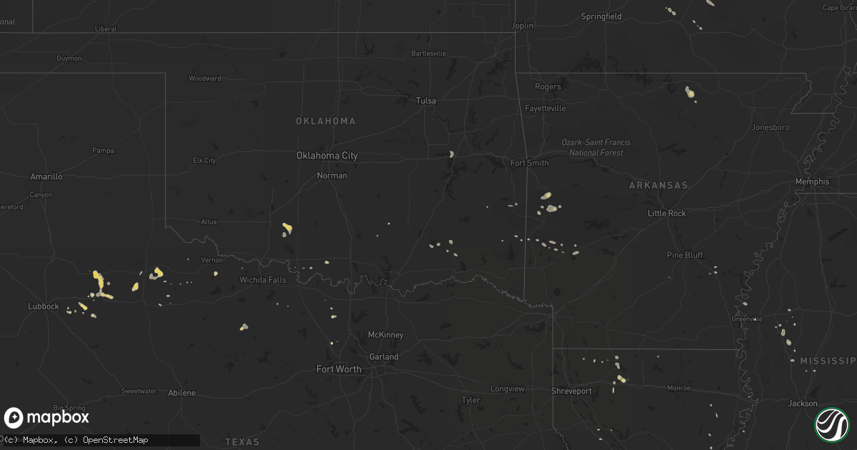
Hail Map on August 10, 2014
Get this storm
August 10 map
$229
one time, instant access
Download today. No call, no setup
Keep the $229
Bought the map and want the full workflow? Apply the entire $229 to a subscription within 7 days. None of it is wasted.
Every map, not just this one
This buys you this map. Subscription and you get every map we run, in the markets you choose from a few cities to whole states to nationwide. Plus real-time alerts the moment a storm fires.
Contact data
Name, contact info, occupancy, even credit band for addresses in the footprint. You go from where it hit to who to call.
Become the source they trust
Unlimited branding weather history reports on demand. You already have the documented answer ready for the property owner, and you are the one who showed up with it.
Property data and RoofTrace estimates
Pull up any address you have got, its value and the exact code rules for that jurisdiction, straight from One Click Code. Then RoofTrace estimates the squares, pitch, and roof value, priced the way you price.
States Impacted by Hail Map on August 10, 2014
Storm reports
California
| Date | Description |
|---|---|
| 08/10/20144:30 PM CDT | Quarter-size hail was reported on the se flank of the eiler fire yesterday at 2:30pm. |
Missouri
| Date | Description |
|---|---|
| 08/10/20144:43 PM CDT | Three foot diameter oak tree reported blown down in yard. |
| 08/10/20144:19 PM CDT | Tree reported down accross highway oo one half mile west of highway o. |
| 08/10/20144:17 PM CDT | A local report indicates 1.00 inch wind near 4 NW LICKING |
Mississippi
| Date | Description |
|---|---|
| 08/10/20146:10 PM CDT | Scattered trees down across county...specifically on hwy 16... Stokes rd... Robinson rd... And virlilia rd. |
| 08/10/20145:34 PM CDT | Trees down on judkins rd... Honeycutt rd... And myrleville rd. |
| 08/10/20145:30 PM CDT | Power lines down across all lanes of hwy 49 near rt braddy road. Corrected location. |
| 08/10/20145:30 PM CDT | Power lines down across all lanes of hwy 49 near star rd. |
| 08/10/20144:40 PM CDT | Power lines down across all lanes of hwy 49 near rt braddy road. In addition...13 pine trees were snapped or uprooted at a property in the area. Corrected time. |
Texas
| Date | Description |
|---|---|
| 08/10/20146:10 PM CDT | Tin roof partially pealed back on building. Location near us 385 and schlemeyer field. Report via facebook. |
| 08/10/20146:07 PM CDT | Powerlines down at w 67th and county road west. |
| 08/10/20145:35 PM CDT | A local report indicates 59 MPH wind near ALPINE |
| 08/10/20144:39 PM CDT | A local report indicates 70 MPH wind near SHEPPARD AFB |
| 08/10/20144:35 PM CDT | Roof damaged on house and trees downed. |
| 08/10/20144:26 PM CDT | A local report indicates 77 MPH wind near SHEPPARD AFB |
| 08/10/20144:24 PM CDT | Small tree limbs downed. |
| 08/10/20143:29 PM CDT | 73 mph wind gusts took out a hams antenna. |
Alabama
| Date | Description |
|---|---|
| 08/10/20144:12 PM CDT | Power lines were knocked down on chapel hill road. Time estimated by radar. |
| 08/10/20143:55 PM CDT | A canopy at a gas station on sandlin drive was toppled over by thunderstorm winds. Time estimated by radar. |
Louisiana
| Date | Description |
|---|---|
| 08/10/20142:34 PM CDT | Kalb meteorologist relayed public report of trees blown down and green house blown over. Pictures posted on kalb fb page shows a large pine tree was uprooted and went t |
| 08/09/20147:40 PM CDT | Numerous trees down |
Arkansas
| Date | Description |
|---|---|
| 08/10/20143:55 PM CDT | Powerlines down across hwy 425. |
Cities Impacted by Hail Map on August 10, 2014
- Oxford, AR
- Salem, AR
- Floydada, TX
- Pineville, LA
- Cripple Creek, CO
- Waldron, AR
- Duncan, OK
- Newcastle, TX
- Athens, LA
- Meridian, MS
- Marion, MS
- Tchula, MS
- La Junta, CO
- Newburg, MO
- Janesville, CA
- Greenville, MS
- Benoit, MS
- Kaiser, MO
- Eldon, MO
- Osage Beach, MO
- Lake Ozark, MO
- Tuscumbia, MO
- Brumley, MO
- Mansfield, AR
- Homer, LA
- Richland, MO
- Rye, CO
- Kim, CO
- Colorado City, CO
- Walsenburg, CO
- Pueblo, CO
- Boles, AR
- Parks, AR
- Mountain Grove, MO
- Robeline, LA
- Lorenzo, TX
- Eustis, NE
- Toomsuba, MS
- Deville, LA
- Rumford, ME
- Duke, MO
- Waynesville, MO
- Rhome, TX
- Electra, TX
- Vernon, TX
- Stonewall, OK
- Licking, MO
- Gibsland, LA
- Itta Bena, MS
- Leroy, AL
- Ringling, OK
- Lawton, OK
- Yazoo City, MS
- Benton, MS
- Grove Hill, AL
- Minden, LA
- Walters, OK
- Sierraville, CA
- Calpine, CA
- Rocky Ford, CO
- Mcadoo, TX
- Murphy, ID
- Chambers, NE
- Watson, OK
- Crosbyton, TX
- Wiseman, AR
- Bexar, AR
- Leland, MS
- Lottie, LA
- Fordoche, LA
- Colorado Springs, CO
- Peyton, CO
- Belzoni, MS
- Paducah, TX
- Decatur, TX
- Sanger, TX
- Arcadia, LA
- Victoria, TX
- Isola, MS
- Mena, AR
- Kentwood, LA
- Inverness, MS
- Ralls, TX
- Rosston, TX
- Muenster, TX
- Dickens, TX
- Vandervoort, AR
- Graff, MO
- Roaring Springs, TX
- Cotopaxi, CO
- Crowell, TX
- Cove, AR
- Young, AZ
- Alexandria, LA
- Woodworth, LA
- Fort Leonard Wood, MO
- Laquey, MO
- Sugar Land, TX
- Cabool, MO
- Smithville, OK
- Gould, AR
- Newhope, AR
- Mountain View, MO
- Heavener, OK
- Hodgen, OK
- Cotton Valley, LA
- Bunkie, LA
- Winnsboro, LA
- Stringtown, OK
- Spur, TX
- Amity, AR
- Murfreesboro, AR
- Kirby, AR
- Antlers, OK
- Olney, TX
- Umpire, AR
- Wister, OK
- Violet Hill, AR
- Marlow, OK
- Checotah, OK
- Lane, OK
- Willow Springs, MO
- Stoutland, MO
- Amite, LA
- Coushatta, LA
- Salem, MO
- Hartshorn, MO
- Bentonia, MS
- Vaughan, MS