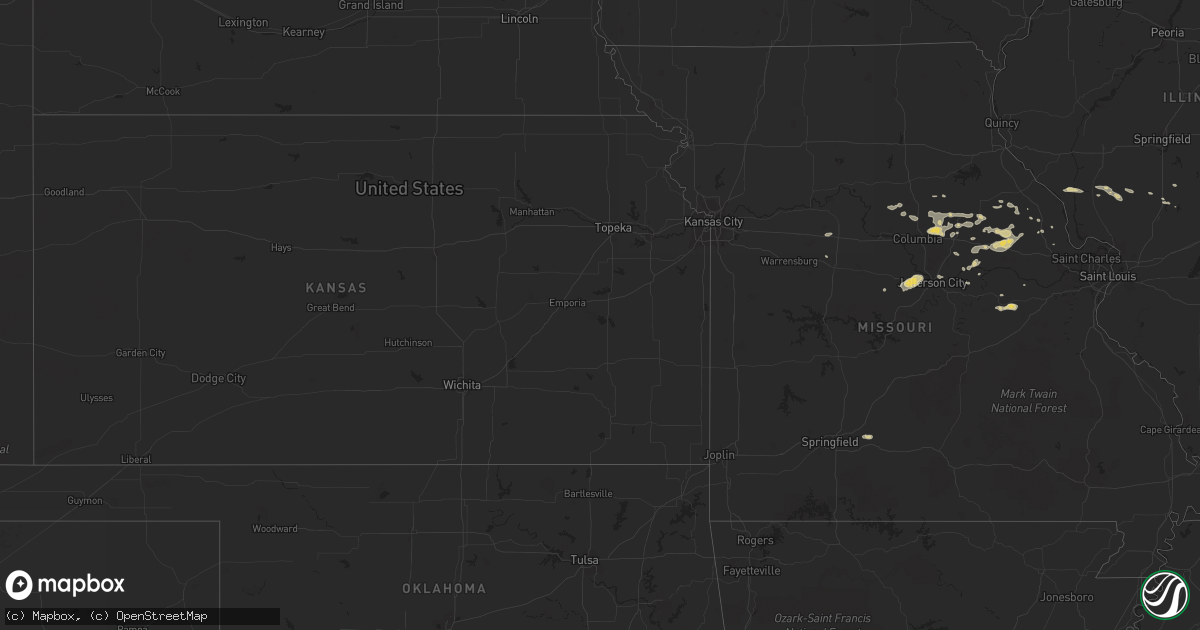
Hail Map on September 13, 2011
Get this storm
September 13 map
$229
one time, instant access
Download today. No call, no setup
Keep the $229
Bought the map and want the full workflow? Apply the entire $229 to a subscription within 7 days. None of it is wasted.
Every map, not just this one
This buys you this map. Subscription and you get every map we run, in the markets you choose from a few cities to whole states to nationwide. Plus real-time alerts the moment a storm fires.
Contact data
Name, contact info, occupancy, even credit band for addresses in the footprint. You go from where it hit to who to call.
Become the source they trust
Unlimited branding weather history reports on demand. You already have the documented answer ready for the property owner, and you are the one who showed up with it.
Property data and RoofTrace estimates
Pull up any address you have got, its value and the exact code rules for that jurisdiction, straight from One Click Code. Then RoofTrace estimates the squares, pitch, and roof value, priced the way you price.
States Impacted by Hail Map on September 13, 2011
Storm reports
California
| Date | Description |
|---|---|
| 09/13/20114:35 PM CDT | Part of building blown onto roadway. |
| 09/13/20114:29 PM CDT | California highway patrol reports power poles down along sr 98 and rood road. |
| 09/13/201111:40 AM CDT | 20 x 40 foot patio cover at fire station ripped by high winds. Palm fronds blown down. Time of damage estimated. |
| 09/13/20119:15 AM CDT | Delayed report. 60 ft tall tree with 3 in. Diameter trunk blown down and demolished a fence. Observer estimated winds to be 60 to 70 mph. |
Arizona
| Date | Description |
|---|---|
| 09/13/20116:40 PM CDT | Power lines down over several houses near maricopa train station at taft and mcdavid. |
| 09/13/20114:36 PM CDT | A trained weather spotter in snowflake az reported 1.25 inch hail and 35 to 40 mph wind gusts from 1426 to 1436 mst. |
Pennsylvania
| Date | Description |
|---|---|
| 09/13/20116:55 PM CDT | Multiple trees down |
| 09/13/20116:20 PM CDT | One tree down on rt 27 |
| 09/13/20115:25 PM CDT | Nickel to quarter size hail. |
| 09/12/20117:39 PM CDT | Few branches down |
| 09/12/20117:15 PM CDT | One tree down on rt 227 |
New York
| Date | Description |
|---|---|
| 09/13/20116:10 PM CDT | Tree fell on transmission line on moose river road cutting power to 5900 people |
| 09/13/20115:58 PM CDT | Trees and wires down on moose river road |
Texas
| Date | Description |
|---|---|
| 09/12/20119:25 PM CDT | Measured by west tx mesonet. |
Ohio
| Date | Description |
|---|---|
| 09/12/20117:20 PM CDT | A local report indicates 1.00 inch wind near 2 N NEWTON FALLS |
| 09/12/20117:03 PM CDT | A local report indicates 1.00 inch wind near GARRETTSVILLE |
Michigan
| Date | Description |
|---|---|
| 09/12/20117:10 PM CDT | A local report indicates 1.75 inch wind near 10 E MASS CITY |
Cities Impacted by Hail Map on September 13, 2011
- Hadley, PA
- Clarks Mills, PA
- Jefferson City, MO
- Lohman, MO
- Centertown, MO
- Curryville, MO
- Bowling Green, MO
- Middletown, MO
- White Hall, IL
- Wrights, IL
- Greenfield, IL
- Chesterfield, IL
- Hettick, IL
- Strawberry Valley, CA
- Rosebud, MO
- Leslie, MO
- Owensville, MO
- Gerald, MO
- High Hill, MO
- New Florence, MO
- Jonesburg, MO
- Mexico, MO
- Thompson, MO
- Latham, MO
- Canyon Country, CA
- Santa Clarita, CA
- Vandalia, MO
- Clarion, PA
- Shippenville, PA
- Lucinda, PA
- Southington, OH
- Windham, OH
- Garrettsville, OH
- Kampsville, IL
- Bradford, PA
- Bellflower, MO
- Montgomery City, MO
- Heber, AZ
- Holtville, CA
- Datil, NM
- Portland, MO
- Rhineland, MO
- Warren, OH
- Leavittsburg, OH
- Newton Falls, OH
- Streetsboro, OH
- Mantua, OH
- Hesperia, CA
- Morrisonville, IL
- Niles, OH
- Girard, OH
- Vienna, OH
- Franklin, PA
- Highland, CA
- New Bethlehem, PA
- Rimersburg, PA
- Waggoner, IL
- Shelbyville, IL
- Tower Hill, IL
- Assumption, IL
- Quemado, NM
- Kennerdell, PA
- Cranberry, PA
- Knox, PA
- Emlenton, PA
- Sedona, AZ
- California, MO
- Russellville, MO
- New Haven, MO
- Auxvasse, MO
- Marshfield, MO
- Fordland, MO
- Seymour, MO
- Slippery Rock, PA
- Hallsville, MO
- Centralia, MO
- Columbia, MO
- Fulton, MO
- Utica, PA
- Litchfield, IL
- Butler, IL
- Raymond, IL
- Carlinville, IL
- Palmyra, IL
- Aguanga, CA
- Spartansburg, PA
- Harrisburg, MO
- Sturgeon, MO
- Wellton, AZ
- Heber, CA
- Calexico, CA
- Snowflake, AZ
- Eldred, IL
- Nebo, IL
- Downieville, CA
- Hughesville, MO
- Phelan, CA
- Desert Center, CA
- Benton City, MO
- Martinsburg, MO
- Foley, MO
- Sligo, PA
- Parker, PA
- Silex, MO
- Taylor, AZ
- Show Low, AZ
- Morrison, MO
- Mecca, CA
- Brookville, PA
- Summerville, SC
- Moncks Corner, SC
- Ridgeville, SC
- Reynoldsville, PA
- Oshkosh, NE
- Wabbaseka, AR
- Holts Summit, MO
- Troy, MO
- Williamsburg, MO
- Rockbridge, IL
- Wellsville, MO
- Cooperstown, PA
- Guys Mills, PA
- Cochranton, PA
- Titusville, PA
- Pleasantville, PA
- Oil City, PA
- Mokane, MO
- Steedman, MO
- Sweet Springs, MO
- Marshall, MO
- Venus, PA
- Kingdom City, MO
- Grove City, PA
- Volant, PA
- Mercer, PA
- Stoneboro, PA
- Polk, PA
- Dayton, PA
- Marble, PA
- Quincy, CA
- Sandy Lake, PA
- Pana, IL
- Findlay, IL
- Thermal, CA
- West Middlesex, PA
- West Farmington, OH
- Laddonia, MO
- Hiram, OH
- Fayette, MO
- Flagstaff, AZ
- Whitewater, CA
- San Bernardino, CA
- Cedarpines Park, CA
- Niland, CA
- East Brady, PA
- Cowansville, PA
- Strattanville, PA
- Atlantic, PA
- Hartstown, PA
- Conneaut Lake, PA
- Anza, CA
- Truxton, MO
- Winterhaven, CA
- Greenville, PA
- Wrightwood, CA
- Pinon Hills, CA
- Hawk Point, MO
- Port Leyden, NY
- Thendara, NY
- Forestport, NY
- Hilliards, PA
- West Sunbury, PA
- Du Bois, PA
- Linn, MO
- Chamois, MO
- Smethport, PA
- Rixford, PA
- Crestline, CA
- Armstrong, MO
- Clark, MO
- Higbee, MO