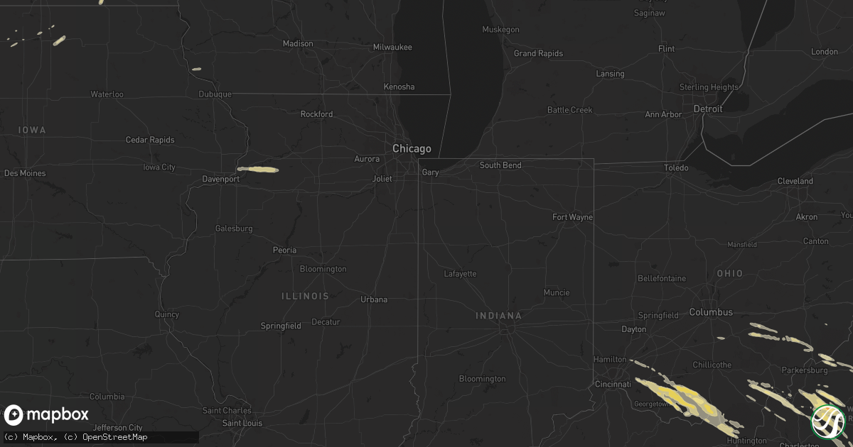
Hail Map in Ohio on March 21, 2011
Get this storm
March 21 map
$229
one time, instant access
Download today. No call, no setup
Keep the $229
Bought the map and want the full workflow? Apply the entire $229 to a subscription within 7 days. None of it is wasted.
Every map, not just this one
This buys you this map. Subscription and you get every map we run, in the markets you choose from a few cities to whole states to nationwide. Plus real-time alerts the moment a storm fires.
Contact data
Name, contact info, occupancy, even credit band for addresses in the footprint. You go from where it hit to who to call.
Become the source they trust
Unlimited branding weather history reports on demand. You already have the documented answer ready for the property owner, and you are the one who showed up with it.
Property data and RoofTrace estimates
Pull up any address you have got, its value and the exact code rules for that jurisdiction, straight from One Click Code. Then RoofTrace estimates the squares, pitch, and roof value, priced the way you price.
Storm reports in Ohio
Ohio
| Date | Description |
|---|---|
| 03/21/20116:50 PM CDT | A local report indicates 1.00 inch wind near 2 E WEST UNION |
| 03/21/20116:20 PM CDT | A local report indicates 1.00 inch wind near IRONTON |
| 03/21/20116:10 PM CDT | Covered the ground in a short period of time. |
| 03/21/20115:09 PM CDT | Corrected for location...portersville instead of corning. |
| 03/21/20115:09 PM CDT | Event occurred between 554 pm 03/21/2011 and 609 pm 03/21/2011 |
| 03/21/20115:09 PM CDT | A local report indicates 1.00 inch wind near 3 NE PORTSMOUTH |
| 03/21/20115:01 PM CDT | Estimated 30 mph winds |
| 03/21/20114:50 PM CDT | A local report indicates 1.00 inch wind near MIDDLEPORT |
| 03/21/20114:39 PM CDT | 3 miles south of peebles |
| 03/21/20114:38 PM CDT | Trees down across the road 3 miles south of peebles. |
| 03/21/20114:36 PM CDT | A local report indicates 1.00 inch wind near 1 WNW MCDERMOTT |
| 03/21/20114:30 PM CDT | Time size and location estimated. |
| 03/21/20114:25 PM CDT | Time is estimated |
| 03/21/20114:24 PM CDT | Time was estimated. Earlier seaman report adjusted to spotter location. |
| 03/21/20114:24 PM CDT | Time was estimated |
| 03/21/20114:13 PM CDT | Time size and location were estimated |
| 03/21/20114:02 PM CDT | Significant portion of metal roof peeled off residence. |
| 03/21/20112:30 PM CDT | A local report indicates 1.00 inch wind near LOWER SALEM |
All States Impacted by Hail Map on March 21, 2011
Cities Impacted by Hail Map on March 21, 2011
- Le Roy, WV
- Gay, WV
- Batavia, OH
- Mount Alto, WV
- Evans, WV
- Millwood, WV
- Rutland, OH
- Wilkesville, OH
- Racine, OH
- Mason, WV
- Langsville, OH
- Cheshire, OH
- Vinton, OH
- West Columbia, WV
- Ripley, WV
- Bidwell, OH
- Middleport, OH
- Cottageville, WV
- Letart, WV
- Wessington, SD
- Wessington Springs, SD
- Cairo, WV
- Saint Marys, WV
- Ellenboro, WV
- Artesian, SD
- Woonsocket, SD
- Ireland, WV
- Sutton, WV
- Hacker Valley, WV
- Flatwoods, WV
- Diana, WV
- Heaters, WV
- Morrow, OH
- Blanchester, OH
- Pleasant Plain, OH
- Spencer, WV
- Reedy, WV
- Virgil, SD
- Nora Springs, IA
- Rockford, IA
- Erie, IL
- Prophetstown, IL
- Tampico, IL
- Orma, WV
- Arnoldsburg, WV
- Grantsville, WV
- Elizabeth, WV
- Munday, WV
- Creston, WV
- Big Bend, WV
- Somerset, OH
- New Lexington, OH
- Stout, OH
- West Union, OH
- Winchester, OH
- Madison, SD
- South Shore, KY
- West Portsmouth, OH
- Peebles, OH
- South Portsmouth, KY
- Rarden, OH
- Portsmouth, OH
- Lucasville, OH
- McDermott, OH
- Hillsboro, OH
- Otway, OH
- Stoutsville, OH
- Amanda, OH
- Circleville, OH
- Midland, OH
- South Point, OH
- Chloe, WV
- Monterville, WV
- Maysel, WV
- Clay, WV
- Clendenin, WV
- Walton, WV
- Indore, WV
- Wallback, WV
- Procious, WV
- Amma, WV
- Summersville, WV
- De Smet, SD
- Lake Preston, SD
- Seaman, OH
- Russell, KY
- Flatwoods, KY
- Southside, WV
- Jane Lew, WV
- New Matamoras, OH
- Reno, OH
- Marietta, OH
- Newport, OH
- Fort Thompson, SD
- Gann Valley, SD
- Cassville, WI
- Glen Haven, WI
- Malta, OH
- Shawnee, OH
- Crooksville, OH
- New Straitsville, OH
- Corning, OH
- Junction City, OH
- Bremen, OH
- Iroquois, SD
- Mount Zion, WV
- Duck, WV
- Shock, WV
- Newton, WV
- Nebo, WV
- Ivydale, WV
- Millstone, WV
- Rosedale, WV
- Ravenswood, WV
- Palestine, WV
- Looneyville, WV
- Sandyville, WV
- Bryant, SD
- Helvetia, WV
- Mill Creek, WV
- Tallmansville, WV
- French Creek, WV
- Gallipolis Ferry, WV
- Henderson, WV
- Mason City, IA
- Miller, SD
- Cowen, WV
- Upperglade, WV
- Le Roy, MN
- Ostrander, MN
- Spring Valley, MN
- Bomont, WV
- Bickmore, WV
- Quinwood, WV
- Cordova, IL
- Deer Grove, IL
- Port Byron, IL
- Hillsdale, IL
- Lowell, OH
- Huron, SD
- Alpena, SD
- Cavour, SD
- Oldham, SD
- Head Waters, VA
- Doe Hill, VA
- Williamsville, VA
- McDowell, VA
- Monterey, VA
- West Augusta, VA
- Mount Orab, OH
- Piketon, OH
- Friendship, OH
- Worthington, KY
- Pedro, OH
- Ironton, OH
- Goshen, OH
- Blue Creek, OH
- Kitts Hill, OH
- Franklin Furnace, OH
- Sardinia, OH
- Williamsburg, OH
- Wheelersburg, OH
- Greenup, KY
- Quincy, KY
- Ashland, KY
- Lynx, OH
- Latham, OH
- Lynchburg, OH
- Georgetown, OH
- Brookings, SD
- West Union, WV
- Middlebourne, WV
- Pennsboro, WV
- Normantown, WV
- Kenna, WV
- Carthage, SD
- Lewisville, OH
- Wolsey, SD
- Marion Station, MD
- Howard, SD
- Garner, IA
- Bartow, WV
- Rock Cave, WV
- Crawford, WV
- Pickens, WV
- Huttonsville, WV
- Mabie, WV
- Adrian, WV
- Arbovale, WV
- Durbin, WV
- Green Bank, WV
- Buckhannon, WV
- Beverly, OH
- Mcconnelsville, OH
- Frametown, WV
- Lower Salem, OH
- Whipple, OH
- Camden On Gauley, WV
- Erbacon, WV
- Providence Forge, VA
- Lanexa, VA
- Charles City, VA
- Gallipolis, OH
- South Lebanon, OH
- Lebanon, OH
- Portland, OH
- Fairbank, IA
- Denver, IA
- Cedar Falls, IA
- Waterloo, IA
- Readlyn, IA
- Janesville, IA
- Dunkerton, IA
- Leon, WV
- Stonyford, CA
- Maxwell, CA
- Warrenton, VA
- Rushville, OH
- Thornville, OH
- Manly, IA
- Valley Head, WV
- Webster Springs, WV
- Gandeeville, WV
- Left Hand, WV
- Mount Nebo, WV
- Gassaway, WV
- Alden, MN
- Wells, MN
- Volga, SD
- Nunda, SD
- Birch River, WV
- Pocomoke City, MD
- Westover, MD
- New Milton, WV
- Arlington, SD
- Clear Lake, IA
- Princess Anne, MD
- Albany, OH
- Rockwell, IA
- Pomeroy, OH
- Britt, IA
- Kimball, SD
- Forest City, IA
- Willow Wood, OH
- Macfarlan, WV


