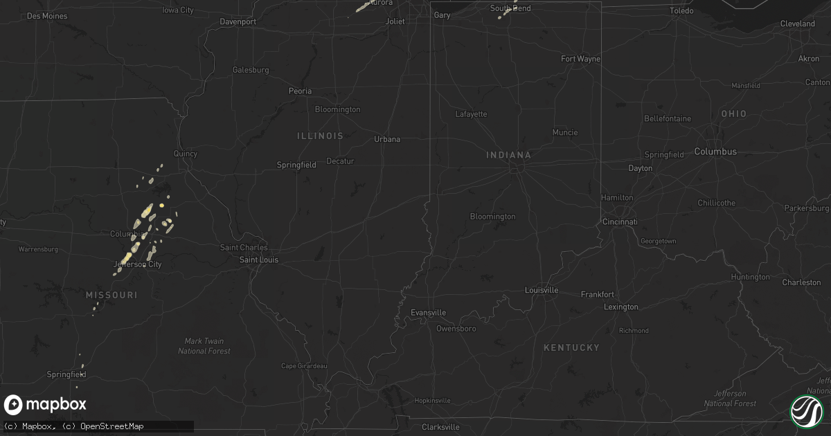
Hail Map in Indiana on May 31, 2011
Get this storm
May 31 map
$229
one time, instant access
Download today. No call, no setup
Keep the $229
Bought the map and want the full workflow? Apply the entire $229 to a subscription within 7 days. None of it is wasted.
Every map, not just this one
This buys you this map. Subscription and you get every map we run, in the markets you choose from a few cities to whole states to nationwide. Plus real-time alerts the moment a storm fires.
Contact data
Name, contact info, occupancy, even credit band for addresses in the footprint. You go from where it hit to who to call.
Become the source they trust
Unlimited branding weather history reports on demand. You already have the documented answer ready for the property owner, and you are the one who showed up with it.
Property data and RoofTrace estimates
Pull up any address you have got, its value and the exact code rules for that jurisdiction, straight from One Click Code. Then RoofTrace estimates the squares, pitch, and roof value, priced the way you price.
Storm reports in Indiana
Indiana
| Date | Description |
|---|---|
| 05/31/20114:30 PM CDT | Power lines down at campeau street and northwood dr |
| 05/31/20114:30 PM CDT | Trees down in south bend and mishawaka. One tree onto a car. |
| 05/31/20114:25 PM CDT | Multiple reports of trees down in the city |
All States Impacted by Hail Map on May 31, 2011
Cities Impacted by Hail Map on May 31, 2011
- Saint Johnsville, NY
- Silverton, TX
- Quitaque, TX
- Clarendon, TX
- Rogers, NM
- Elida, NM
- Pep, NM
- Portales, NM
- Buffalo, OK
- Hale, MI
- Blanchard, MI
- Midland, MI
- Coleman, MI
- Hope, MI
- Breckenridge, MI
- Sanford, MI
- Linwood, MI
- Shepherd, MI
- Mount Pleasant, MI
- Pinconning, MI
- Saint Louis, MI
- Mexico, MO
- Eden Mills, VT
- Albany, VT
- Lowell, VT
- Barton, VT
- Craftsbury Common, VT
- Irasburg, VT
- Glover, VT
- Eden, VT
- Lovington, NM
- Hobbs, NM
- Childress, TX
- Lockney, TX
- Glennie, MI
- Oscoda, MI
- Otego, NY
- Unadilla, NY
- Morton, TX
- Tebbetts, MO
- Tulia, TX
- Laddonia, MO
- Lubbock, TX
- Levelland, TX
- Ropesville, TX
- Roswell, NM
- Lake Placid, NY
- Fort Supply, OK
- Tatum, NM
- Memphis, TX
- Camdenton, MO
- East Tawas, MI
- Matador, TX
- Flomot, TX
- Seminole, TX
- Rosebush, MI
- Northville, NY
- Gloversville, NY
- Posen, MI
- Sidney, NY
- Fulton, MO
- Keeseville, NY
- Burlington, VT
- Willsboro, NY
- Miami, TX
- Perryton, TX
- Friona, TX
- Kalkaska, MI
- Mancelona, MI
- Hartley, TX
- Dalhart, TX
- Vega, TX
- Hereford, TX
- Six Lakes, MI
- Edmore, MI
- Hallsville, MO
- Columbia, MO
- Centralia, MO
- Richfield Springs, NY
- Coldwater, KS
- Freedom, OK
- Stinnett, TX
- Thompson, MO
- South Plymouth, NY
- Smyrna, NY
- Plymouth, NY
- Shallowater, TX
- Shattuck, OK
- Fargo, OK
- Gage, OK
- Bay Port, MI
- Pigeon, MI
- Caseville, MI
- Ithaca, MI
- North Star, MI
- Wheeler, MI
- Bad Axe, MI
- Russellville, MO
- Spearman, TX
- Cold Brook, NY
- Beaverton, MI
- Auxvasse, MO
- Martinsburg, MO
- Kress, TX
- Ashland, MO
- Mason, MI
- Onondaga, MI
- Eaton Rapids, MI
- Carthage, NY
- Castorland, NY
- Gladwin, MI
- Fritch, TX
- Lowville, NY
- Long Lake, NY
- National City, MI
- Whittemore, MI
- Turner, MI
- May, OK
- Pampa, TX
- Jefferson City, MO
- Centertown, MO
- Hartsburg, MO
- Frankenmuth, MI
- Skellytown, TX
- White Deer, TX
- Groom, TX
- Newcomb, NY
- West Chicago, IL
- Spruce, MI
- Black River, MI
- Ossineke, MI
- Niles, MI
- Granger, IN
- Edwardsburg, MI
- Shelbina, MO
- Paris, MO
- Chesaning, MI
- Oakley, MI
- Lakeview, TX
- Franklin, NY
- Turkey, TX
- Waterville, NY
- North Brookfield, NY
- Madison, NY
- Presque Isle, MI
- Borger, TX
- Hillman, MI
- Atlanta, MI
- Croghan, NY
- Lowell, MI
- Belding, MI
- Saranac, MI
- Johannesburg, MI
- Gaylord, MI
- Hawks, MI
- Delancey, NY
- East Hardwick, VT
- Delhi, NY
- Walton, NY
- Wellsville, MO
- Fort Plain, NY
- Macks Creek, MO
- Alva, OK
- Elsie, MI
- West Winfield, NY
- Hamden, NY
- Strafford, MO
- Schroon Lake, NY
- North Hudson, NY
- Orleans, MI
- Cooperstown, NY
- Springfield Center, NY
- Fly Creek, NY
- Lewiston, MI
- Idalou, TX
- Rogersville, MO
- Mooreland, OK
- Wilmore, KS
- North Liberty, IN
- Kinde, MI
- Filion, MI
- Montgomery City, MO
- Imlay City, MI
- Brown City, MI
- Yale, MI
- Bovina, TX
- Farwell, TX
- Canajoharie, NY
- Cherry Valley, NY
- South Bend, IN
- Lapeer, MI
- Davison, MI
- Cedar Springs, MI
- Fair Grove, MO
- Elkland, MO
- Alpena, MI
- Touchet, WA
- Vestaburg, MI
- East Springfield, NY
- Hagerman, NM
- Owendale, MI
- Gagetown, MI
- New Berlin, NY
- Island Pond, VT
- Rhodes, MI
- Tawas City, MI
- Floydada, TX
- Clare, MI
- Bentley, MI
- Sterling, MI
- Standish, MI
- Fonda, NY
- Palatine Bridge, NY
- Woodward, OK
- Remsen, NY
- Wellington, TX
- Bretton Woods, NH
- Franconia, NH
- Hemlock, MI
- Trufant, MI
- Sand Lake, MI
- Lancaster, NH
- Onaway, MI
- Afton, MI
- Cheboygan, MI
- Sparta, MO
- Randolph, NH
- Jefferson, NH
- Akron, MI
- Unionville, MI
- Memphis, MI
- Norwich, NY
- Sherburne, NY
- Saginaw, MI
- Mount Upton, NY
- Guilford, NY
- South New Berlin, NY
- New Bloomfield, MO
- Alma, MI
- Rogers City, MI
- Rockford, MI
- Shelburne, VT
- Colchester, VT
- Essex Junction, VT
- Jay, NY
- Lewis, NY
- Au Sable Forks, NY
- South Burlington, VT
- Winooski, VT
- Saranac Lake, NY
- Hagaman, NY
- Amsterdam, NY
- Broadalbin, NY
- Galway, NY
- Sharon, OK
- Lisbon, NH
- Bath, NH
- Sugar Hill, NH
- Twining, MI
- Lincoln, MI
- Harrisville, MI
- Lake City, KS
- Dolgeville, NY
- Reese, MI
- Sidney Center, NY
- Colon, MI
- Aurora, IL
- Sugar Grove, IL
- North Aurora, IL
- Batavia, IL
- Merrill, MI
- Saint Charles, MI
- Ionia, MI
- Fenwick, MI
- Greenville, MI
- Oxford, NY
- Monroe City, MO
- Hunnewell, MO
- Hedley, TX
- Quail, TX
- South Ryegate, VT
- Somonauk, IL
- Sandwich, IL
- Crystal, MI
- Riverdale, MI
- Brant, MI
- Edmeston, NY
- Newport, NY
- Philadelphia, MO
- Lohman, MO
- Caroga Lake, NY
- Kingdom City, MO
- McDonough, NY
- Roach, MO
- Groton, VT
- Plainview, TX
- Holliday, MO
- Madison, MO
- Lacona, NY
- Barton City, MI
- Elwell, MI
- Booker, TX
- Cincinnatus, NY
- Northfield, VT
- Lorraine, NY
- Saint Johns, MI
- Williamsburg, MO
- Mishawaka, IN
- Channing, TX
- Prescott, MI
- Sebewaing, MI
- Lachine, MI
- Coral, MI
- Mokane, MO
- Fowlerville, MI
- Webberville, MI
- Williamston, MI
- Metamora, MI
- Perry, MO
- Big Rock, IL
- Plano, IL
- Millersburg, MI
- Vandalia, MO
- Keyes, OK
- Alger, MI
- Leland, IL


