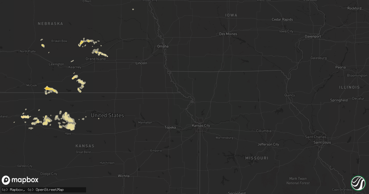
Hail Map in South Carolina on July 13, 2011
Get this storm
July 13 map
$229
one time, instant access
Download today. No call, no setup
Keep the $229
Bought the map and want the full workflow? Apply the entire $229 to a subscription within 7 days. None of it is wasted.
Every map, not just this one
This buys you this map. Subscription and you get every map we run, in the markets you choose from a few cities to whole states to nationwide. Plus real-time alerts the moment a storm fires.
Contact data
Name, contact info, occupancy, even credit band for addresses in the footprint. You go from where it hit to who to call.
Become the source they trust
Unlimited branding weather history reports on demand. You already have the documented answer ready for the property owner, and you are the one who showed up with it.
Property data and RoofTrace estimates
Pull up any address you have got, its value and the exact code rules for that jurisdiction, straight from One Click Code. Then RoofTrace estimates the squares, pitch, and roof value, priced the way you price.
Storm reports in South Carolina
South Carolina
| Date | Description |
|---|---|
| 07/13/20114:50 PM CDT | Tree down at bellview church road and bethany church road. Time estimated from radar. |
| 07/13/20114:36 PM CDT | A local report indicates 1.00 inch wind near BAYBORO |
| 07/13/20114:36 PM CDT | Three trees were blown down on hwy 410. |
| 07/13/20114:35 PM CDT | Chaser also reported nickel sized hail |
| 07/13/20114:33 PM CDT | Tree fell on a car on green sea road. |
| 07/13/20114:28 PM CDT | Multiple trees down at w main st ext and haynes rd. Time estimated from radar. |
| 07/13/20114:26 PM CDT | Tree down at sc hwy 9 and sc hwy 99. Time estimated from radar. |
| 07/13/20114:21 PM CDT | Tree down at lando rd and edgeland rd. |
| 07/13/20114:19 PM CDT | Large limbs down. |
| 07/13/20114:12 PM CDT | Sc highway patrol reports a tree in the roadway near holiday dam road and harper street. |
| 07/13/20114:03 PM CDT | Sc highway patrol reports a tree blocking the roadway near the intersection of hw-49 and kingbury road. |
| 07/13/20113:59 PM CDT | Large pine tree down on a roof. Time estimated based off radar. |
| 07/13/20113:54 PM CDT | Multiple reports of trees down in the city of greenwood. |
| 07/13/20113:54 PM CDT | Trained spotter reports 3 or 4 medium size trees snapped in half. |
| 07/13/20113:51 PM CDT | Tree down...blocked one lane of traffic on beltline rd going towards carlisle. |
| 07/13/20113:51 PM CDT | Tree down blocked one lane of traffic on sims ave near the old sims school. Time estimated from radar. |
| 07/13/20113:40 PM CDT | Sc highway patrol reported trees down at lucknow road and dee lee way |
| 07/13/20113:30 PM CDT | Two trees down. One near the intersection of hw-9 and hw-99 and the other on richburg road near beaver dam road. |
| 07/13/20113:28 PM CDT | Tree down on new market rd. |
| 07/13/20113:22 PM CDT | Large limbs down on east home ave. |
| 07/13/20113:18 PM CDT | Trees down at the intersection of north center rd and patrick hwy. Two mobile homes damaged. |
| 07/13/20113:00 PM CDT | Tree down at hwy 321 and columbia road. |
| 07/13/20113:00 PM CDT | Tree down on cornwell road just west of cornwell. |
| 07/13/20113:00 PM CDT | Highway patrol reported trees down in chappells. |
| 07/13/20112:46 PM CDT | Sheriff dispatch reported trees down at greenwood hwy atnd larkin rice road. |
| 07/13/20112:46 PM CDT | Aiken awos reported a wind gust of 51 knots or 59 mph. |
| 07/13/20112:20 PM CDT | Highway patrol reported trees down near winnsboro along hwy 200. |
| 07/13/20112:15 PM CDT | Sheriff dispatch reported several larege limbs down on maybinton road and gilliam spring road. |
| 07/13/20111:50 PM CDT | Highway patrol reported trees down south of monetta in aiken county. |
| 07/13/20111:44 PM CDT | Highway patrol reported trees down at old golf course road and hwy 178. |
| 07/13/20111:43 PM CDT | Highway patrol reported trees down near batesburg. |
| 07/13/20111:17 PM CDT | Highway patrol reported trees down on kyzer road near platt springs road. |
| 07/12/20117:50 PM CDT | Quarter-sized hail reported in crowfield plantation |
| 07/12/20117:46 PM CDT | A fire department reported a tree and several limbs down on highway 45 near alvin south carolina. |
All States Impacted by Hail Map on July 13, 2011
Cities Impacted by Hail Map on July 13, 2011
- Huntington, UT
- Trussville, AL
- Leeds, AL
- Birmingham, AL
- Rome, GA
- Brunson, SC
- Malvern, AR
- Fort Collins, CO
- Broadview, MT
- Acton, MT
- Whitlash, MT
- Cassatt, SC
- Bishopville, SC
- Camden, SC
- Millport, AL
- Covington, GA
- Great Falls, MT
- Callaway, NE
- Gothenburg, NE
- Brady, NE
- Berry, AL
- Cascade, MT
- Lewistown, MT
- Bruce, MS
- Water Valley, MS
- Sedalia, CO
- Watonga, OK
- Box Elder, MT
- Monticello, AR
- Wilmar, AR
- Monroe, LA
- West Monroe, LA
- Hill City, KS
- Bogue, KS
- Green River, UT
- Vernal, UT
- Belt, MT
- Troutman, NC
- Mooresville, NC
- Cleveland, NC
- Statesville, NC
- Charleston, MS
- Elk City, ID
- Shepherd, MT
- Kalispell, MT
- Somers, MT
- Vega, TX
- Goodwell, OK
- Farmerville, LA
- Oakboro, NC
- Polkton, NC
- Marshville, NC
- Abbeville, MS
- Oxford, MS
- Wayne, NE
- Robbins, NC
- Seagrove, NC
- Chinook, MT
- Carthage, NC
- White Sulphur Springs, MT
- Louviers, CO
- Littleton, CO
- Bethune, SC
- Aurora, CO
- Bard, NM
- San Jon, NM
- Marysville, MT
- Lincoln, MT
- Canyon Creek, MT
- Colorado Springs, CO
- Quitman, AR
- Plainville, KS
- Natoma, KS
- Stockton, KS
- Timnath, CO
- Orange, VA
- Granite Canon, WY
- Cheyenne, WY
- Livermore, CO
- Stockett, MT
- Brooklyn, MS
- Beaumont, MS
- McLain, MS
- Abbeville, AL
- Newville, AL
- West, MS
- Hardtner, KS
- Booneville, AR
- Blountsville, AL
- Hayden, AL
- Scott, AR
- Lonoke, AR
- Hoxie, KS
- Washington, GA
- Green Bay, VA
- Victoria, VA
- Marquette, NE
- Matheson, CO
- Polaris, MT
- Dillon, MT
- Mantee, MS
- Hamburg, AR
- Crossett, AR
- Riverton, NE
- Franklin, NE
- Rexford, KS
- Thompson, UT
- Pine Bluff, AR
- Altheimer, AR
- Grady, AR
- Vaiden, MS
- Saint Libory, NE
- Saint Paul, NE
- Palmer, NE
- Bastrop, LA
- Benton, AR
- Thomasville, AL
- Chester, SC
- Blackstock, SC
- Swanquarter, NC
- Empire, AL
- Bremen, AL
- Molino, FL
- Helena, MT
- Greenwood, AR
- Rison, AR
- Buffalo, WY
- Solgohachia, AR
- Gould, AR
- Stuttgart, AR
- Gillett, AR
- De Witt, AR
- Denver, CO
- Sterlington, LA
- Hamptonville, NC
- Hamlet, NC
- Hot Springs National Park, AR
- Pearcy, AR
- Springfield, AR
- Damascus, AR
- Hattiesburg, MS
- Perryville, AR
- Prattsville, AR
- Hartford, AR
- Mansfield, AR
- Huntington, AR
- Polson, MT
- Gordo, AL
- Fritch, TX
- Masterson, TX
- Lloyd, MT
- Spiro, OK
- Cameron, OK
- Pocola, OK
- Loveland, CO
- Taylorsville, NC
- Morland, KS
- Penokee, KS
- Collyer, KS
- Townsend, MT
- Norwood, NC
- Locust, NC
- Albemarle, NC
- Mount Pleasant, NC
- Edgemoor, SC
- Rock Hill, SC
- Ferron, UT
- Mulberry, AR
- Bladenboro, NC
- Clarkton, NC
- Colby, KS
- Lexington, SC
- Gilbert, SC
- Batesburg, SC
- Leesville, SC
- Hot Springs Village, AR
- Hogeland, MT
- Clarendon, NC
- Chadbourn, NC
- Norton, KS
- Wilsonville, NE
- Norcatur, KS
- Carthage, AR
- Leola, AR
- Winchester, VA
- Stephenson, VA
- Berryville, VA
- Newberry, SC
- Pomaria, SC
- Whitmire, SC
- Wisdom, MT
- Keota, OK
- Bokoshe, OK
- Hildreth, NE
- Minden, NE
- Wilcox, NE
- Axtell, NE
- Kingsland, AR
- Almyra, AR
- Sherrill, AR
- Star City, AR
- White Hall, AR
- Viborg, SD
- Currie, NC
- Rocky Point, NC
- Ringwood, OK
- Tabor City, NC
- Galivants Ferry, SC
- Loris, SC
- Green Sea, SC
- Conway, SC
- Aynor, SC
- Rutherfordton, NC
- Lake Lure, NC
- Marion, NC
- Old Fort, NC
- Union Mills, NC
- Bailey, NC
- Sims, NC
- Rawlins, WY
- Kings Mountain, NC
- Cherryville, NC
- Shelby, NC
- Romance, AR
- Mount Vernon, AR
- Meridian, MS
- Enterprise, MS
- Ryegate, MT
- Lavina, MT
- Molt, MT
- Wetumpka, AL
- Fayette, AL
- Jackson, MT
- Tuskegee, AL
- Tallassee, AL
- Shorter, AL
- Columbia, SC
- Bismarck, AR
- Chunky, MS
- Cut Bank, MT
- Shannon, NC
- Lumber Bridge, NC
- Red Springs, NC
- Trinidad, CO
- Scotia, NE
- Elba, NE
- Buffalo Creek, CO
- Conifer, CO
- Georgetown, SC
- Berthoud, CO
- Lyons, CO
- Windsor, CO
- Dodson, MT
- Park City, MT
- Farwell, MN
- Anadarko, OK
- Ninety Six, SC
- Forest, VA
- Hendley, NE
- Almena, KS
- Beaver City, NE
- Elizabethtown, NC
- Garland, NC
- Elbert, CO
- Elizabeth, CO
- Okeene, OK
- Madison, GA
- Columbia, LA
- Big Sandy, MT
- Kremlin, MT
- Louise, MS
- McClellanville, SC
- Jamestown, SC
- Enola, AR
- Greenbrier, AR
- Jacksonville, AR
- England, AR
- Vilonia, AR
- Conway, AR
- Little Rock Air Force Base, AR
- Cabot, AR
- Lakeville, MA
- Pangburn, AR
- Searcy, AR
- Letona, AR
- Mcalister, NM
- Aline, OK
- Loup City, NE
- Ashton, NE
- North Loup, NE
- Tie Siding, WY
- Buford, WY
- Ashburn, VA
- Round Hill, VA
- Haymarket, VA
- Purcellville, VA
- Middleburg, VA
- Aldie, VA
- The Plains, VA
- Leesburg, VA
- Wagener, SC
- Aiken, SC
- Keenesburg, CO
- Hudson, CO
- Bennett, CO
- Commerce City, CO
- Watkins, CO
- Texhoma, OK
- Vale, NC
- Victoria, KS
- Catharine, KS
- Gorham, KS
- Ellis, KS
- Hays, KS
- Bearden, AR
- Hampton, AR
- Chapman, NE
- Wagram, NC
- Fountain, CO
- State Line, MS
- Goode, VA
- Jack, AL
- Stony Point, NC
- Hiddenite, NC
- South Royalton, VT
- Sharon, VT
- Hopkins, SC
- Craig, CO
- Grover, NC
- Blacksburg, SC
- Hobson, MT
- Cordesville, SC
- Glendo, WY
- Billings, MT
- Angela, MT
- Rosebud, MT
- Wolf Creek, MT
- Oilmont, MT
- Lancaster, SC
- Clayton, NM
- Brandon, MS
- Braxton, MS
- Winnsboro, SC
- Cleo Springs, OK
- Moncks Corner, SC
- Ladson, SC
- Goose Creek, SC
- Summerville, SC
- Gordonsville, VA
- Louisa, VA
- Slater, CO
- Bloomington, NE
- Russellville, AR
- Rye, CO
- Anaconda, MT
- Star, NC
- Foster, VA
- Cardinal, VA
- North, VA
- Mathews, VA
- Thomaston, AL
- Catherine, AL
- Union, SC
- Liberty, NC
- Julian, NC
- Greensboro, NC
- Tignall, GA
- Greenwood, SC
- Livingston, AL
- Sparkman, AR
- Whiteville, NC
- Glenwood, AR
- Dover, AR
- Manville, WY
- Reform, AL
- Maxton, NC
- Hickory Flat, MS
- Etta, MS
- Myrtle, MS
- Potts Camp, MS
- Thaxton, MS
- Peyton, CO
- Sardis, MS
- Batesville, MS
- Hartsville, SC
- Sims, AR
- Deer Lodge, MT
- Alexandria, MN
- Englewood, CO
- Campbell, NE
- Upland, NE
- Wakeeney, KS
- McDavid, FL
- Sanford, NC
- Broadway, NC
- Uniontown, AL
- Tylertown, MS
- Wolbach, NE
- Paris, AR
- Lumberton, NC
- Pueblo, CO
- Tifton, GA
- Dannebrog, NE
- Avon, MT
- Elberton, GA
- Mechanicsville, MD
- Moab, UT
- Charlotte Hall, MD
- Zebulon, NC
- Bunn, NC
- Louisburg, NC
- Spring Hope, NC
- Moore, MT
- Mount Croghan, SC
- Traskwood, AR
- Atkinson, NC
- Como, MS
- Larkspur, CO
- Bluemont, VA
- Longmont, CO
- Winston, MT
- Parker, CO
- Melrose, NM
- Bogue Chitto, MS
- Spearsville, LA
- Ridgeway, SC
- Elgin, SC
- Loyal, OK
- Omega, OK
- Kingfisher, OK
- Aberdeen, NC
- Southern Pines, NC
- Raeford, NC
- Fort Bragg, NC
- Hitchcock, OK
- Hampton, NE
- Central City, NE
- La Plata, MD
- Rose Bud, AR
- Shelby, MT
- Laurel Hill, NC
- Rockingham, NC
- Monroe, NC
- Indian Trail, NC
- Bailey, CO
- Kiowa, CO
- Inwood, IA
- Canton, SD
- Clarks Hill, SC
- Waynesboro, MS
- Silas, AL
- Gable, SC
- New Zion, SC
- York, AL
- Columbia, MS
- Lugoff, SC
- Ty Ty, GA
- Sumner, GA
- Huger, SC
- Boulder, CO
- Raynesford, MT
- Heber Springs, AR
- Highwood, MT
- Dutton, VA
- Gloucester, VA
- Springville, AL
- Ellerbe, NC
- Candor, NC
- Dickinson, AL
- Magazine, AR
- Bonanza, UT
- Cumming, GA
- Fairview, OK
- Safford, AL
- Orrville, AL
- Thermopolis, WY
- Florence, SC
- Columbus, MS
- Steens, MS
- Caledonia, MS
- Shoup, ID
- Pomfret, MD
- Newburg, MD
- Faulkner, MD
- Bel Alton, MD
- Port Tobacco, MD
- Harkers Island, NC
- Royal, AR
- Ferguson, NC
- Wellington, CO
- Laporte, CO
- Louin, MS
- Opelika, AL
- Maple Hill, NC
- Raleigh, MS
- Sherwood, AR
- Helena, OK
- Fairfield, AL
- Dolomite, AL
- Wise River, MT
- Sheridan, WY
- Marion, LA
- Jessieville, AR
- Duchesne, UT
- Lennox, SD
- Centerville, SD
- Atkins, AR
- London, AR
- Pottsville, AR
- Gilbert, LA
- Ivanhoe, NC
- Delhi, LA
- Arley, AL
- China Grove, NC
- Mount Ulla, NC
- Silverstreet, SC
- Chappells, SC
- Texline, TX
- Stephens, AR
- Atmore, AL
- Alva, OK
- Simla, CO
- Hickory, NC
- Newton, NC
- Beloit, KS
- Salisbury, NC
- Bessemer, AL
- Lillie, LA
- Bigfork, MT
- Laurinburg, NC
- Rowland, NC
- Saint Stephen, SC
- Leakesville, MS
- Grinnell, KS
- West Point, MS
- Byers, CO
- Wiggins, CO
- Chugwater, WY
- Landis, NC
- Lincolnton, GA
- Newborn, GA
- Mathews, AL
- Mena, AR
- Bonneau, SC
- Gem, KS
- Two Dot, MT
- Kenton, OK
- Shorterville, AL
- Fort Morgan, CO
- Grove Hill, AL
- Newbern, AL
- West End, NC
- Pinehurst, NC
- Hayden, CO
- Courtland, MS
- Columbus, GA
- Fordyce, AR
- Augusta, AR
- Bald Knob, AR
- Grainfield, KS
- Tallulah, LA
- Marston, NC
- Yazoo City, MS
- Bentonia, MS
- Isabella, OK
- Charlotte, NC
- Concord, NC
- Harrisburg, NC
- Midland, NC
- Brush, CO
- Akron, CO
- Notasulga, AL
- Junction City, AR
- Kinards, SC
- Clover, SC
- Springfield, CO
- Camden, AL
- Vredenburgh, AL
- Hays, MT
- Thornton, AR
- Fountain Hill, AR
- Calhan, CO
- Jasper, AL
- Pine, CO
- Harlem, MT
- Morven, NC
- Wadesboro, NC
- Rock Valley, IA
- Herndon, VA
- Sapphire, NC
- Ramer, AL
- Oakley, KS
- Dalhart, TX
- Amity, AR
- Kirby, AR
- Lakeside, MT
- Castle Rock, CO
- Lone Tree, CO
- Chapin, SC
- Kershaw, SC
- Waldron, AR
- Jefferson, SC
- McBee, SC
- Strasburg, CO
- Wanette, OK
- Macomb, OK
- Kensington, MN
- Wheat Ridge, CO
- Philadelphia, MS
- Loring, MT
- Buhl, AL
- Bonnerdale, AR
- Belton, SC
- Honea Path, SC
- Hanceville, AL
- Saluda, SC
- Epes, AL
- Middlesex, NC
- Franklinton, NC
- Youngsville, NC
- Creedmoor, NC
- Wake Forest, NC
- Stanfield, NC
- Shady Dale, GA
- Monticello, GA
- Stonewall, MS
- Addison, AL
- Houston, AL
- Mcdonough, GA
- Jackson, GA
- Elrod, AL
- Sandy Hook, MS
- Crouse, NC
- Saint Pauls, NC
- Prosperity, SC
- Barnesville, GA
- Subiaco, AR
- New Blaine, AR
- Milton, FL
- Bradley, SC
- Sheridan, AR
- Riegelwood, NC
- Morrison, CO
- Faunsdale, AL
- Browning, MT
- Colorado City, CO
- Ridge Spring, SC
- Trenton, SC
- Evergreen, NC
- Baskin, LA
- Adrian, TX
- Fitzpatrick, AL
- Sparta, GA
- Mount Gilead, NC
- McDonald, TN
- Osborne, KS
- Waldo, KS
- Johnston, SC
- Ward, SC
- Eastman, GA
- Talbotton, GA
- Farwell, NE
- Arlington, GA
- Limon, CO
- Chattanooga, TN
- Waxhaw, NC
- Clancy, MT
- Eupora, MS
- Stewart, MS
- Tutwiler, MS
- Hays, NC
- Denton, GA
- Hazlehurst, GA
- Petal, MS
- Ovett, MS
- Lambert, MS
- Marks, MS
- Enid, MS
- Fitzgerald, GA
- Havre, MT
- Lucedale, MS
- McLeod, MT
- Evergreen, CO
- Golden, CO
- Yadkinville, NC
- Scranton, SC
- Coward, SC
- Gloucester, NC
- Beaufort, NC
- York, SC
- Hodges, SC
- Hartsfield, GA
- Moultrie, GA
- Gold Creek, MT
- Quinter, KS
- Morton, TX
- Dawsonville, GA
- Ball Ground, GA
- Lamar, SC
- Kevin, MT
- Ashville, AL
- Darby, MT
- Greenwood, FL
- Marianna, FL
- Malone, FL
- Titus, AL
- Donaldson, AR
- Ragland, AL
- Guy, AR
- Roggen, CO
- Sweet Water, AL
- Pennington, AL
- Raleigh, NC
- Garner, NC
- Hartman, AR
- Scranton, AR
- Crane Hill, AL
- Shelby, MS
- Winnsboro, LA
- Anguilla, MS
- Butler, AL
- Double Springs, AL
- Kingstree, SC
- Salters, SC
- Buckatunna, MS
- Millry, AL
- Paron, AR
- Muleshoe, TX
- Lonsdale, AR
- Spotsylvania, VA
- Lilesville, NC
- Hoffman, NC
- Lauderdale, MS
- Mendenhall, MS
- Greycliff, MT
- Carthage, MS
- Walnut Grove, MS
- Richton, MS
- Irene, SD
- Biscoe, NC
- Phenix City, AL
- Riverdale, NE
- Amherst, NE
- Mocksville, NC
- Harmony, NC
- Boulder, MT
- Newport, NC
- Story, AR
- Pencil Bluff, AR
- Matthews, NC
- Palco, KS
- Hennessey, OK
- Dover, OK
- Rockwell, NC
- Kannapolis, NC
- Stanford, MT
- Geyser, MT
- Wagarville, AL
- Warm Springs, MT
- Merigold, MS
- Mound Bayou, MS
- Brighton, CO
- Thornton, CO
- Worthing, SD
- Windsor, SC
- Fort Smith, AR
- Montgomery, AL
- Ooltewah, TN
- Bellvue, CO
- Traphill, NC
- Thurmond, NC
- Ozark, AR
- Drasco, AR
- Sterling, VA
- Plainview, AR
- Tichnor, AR
- Demopolis, AL
- Buford, GA
- Aberdeen, MS
- Quitman, MS
- New Edinburg, AR
- Taylorsville, MS
- Bay Springs, MS
- Wendell, NC
- El Paso, AR
- Austin, AR
- Timmonsville, SC
- Pine Hill, AL
- Magnolia, AL
- Bozeman, MT
- Lafayette, AL
- Moody, AL
- Folsom, LA
- Augusta, GA
- Mulga, AL
- Adger, AL
- Clarksdale, MS
- Duncanville, AL
- Cottondale, AL
- Cuba, AL
- Ralph, AL
- Cape Charles, VA
- Stapleton, NE
- Arnold, NE
- Tuscaloosa, AL
- Grapevine, AR
- Broxton, GA
- Cordele, GA
- Vienna, GA
- Sunburst, MT
- Poyen, AR
- Selden, KS
- Fruitdale, AL
- Evington, VA
- Louisville, CO
- Awendaw, SC
- Lynchburg, VA
- Adamsville, AL
- Graysville, AL
- Idaho Springs, CO
- Greenville, AL
- Floyd, NM
- Melvin, AL
- Gilbertown, AL
- Cedar Island, NC
- Purlear, NC
- Wilkesboro, NC


