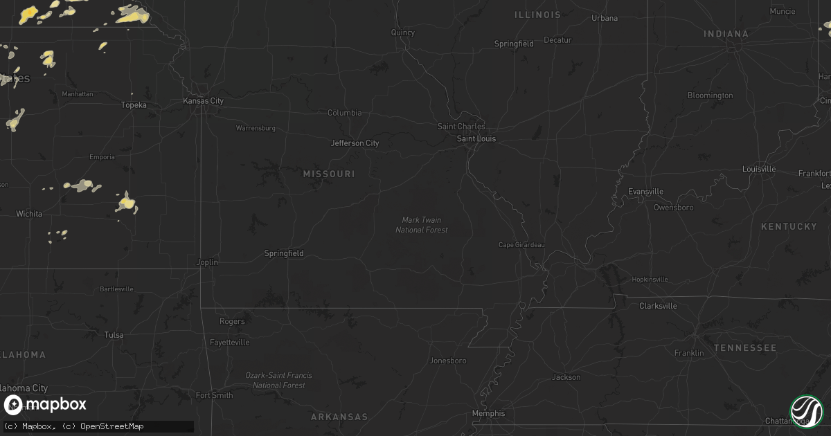
Hail Map in Michigan on July 25, 2012
Get this storm
July 25 map
$229
one time, instant access
Download today. No call, no setup
Keep the $229
Bought the map and want the full workflow? Apply the entire $229 to a subscription within 7 days. None of it is wasted.
Every map, not just this one
This buys you this map. Subscription and you get every map we run, in the markets you choose from a few cities to whole states to nationwide. Plus real-time alerts the moment a storm fires.
Contact data
Name, contact info, occupancy, even credit band for addresses in the footprint. You go from where it hit to who to call.
Become the source they trust
Unlimited branding weather history reports on demand. You already have the documented answer ready for the property owner, and you are the one who showed up with it.
Property data and RoofTrace estimates
Pull up any address you have got, its value and the exact code rules for that jurisdiction, straight from One Click Code. Then RoofTrace estimates the squares, pitch, and roof value, priced the way you price.
Storm reports in Michigan
Michigan
| Date | Description |
|---|---|
| 07/25/201210:30 AM CDT | Tree down on house. |
| 07/25/201212:05 AM CDT | Trees were reported down in and around lexington. |
| 07/25/201212:05 AM CDT | Large willow reported down across coldwater road near north elms road |
| 07/25/201212:00 AM CDT | A large tree was blown down onto m 15. |
| 07/24/201211:42 PM CDT | Numerous tree branches down across the city. Largest size seen was 4 inches in diameter. |
| 07/24/201211:30 PM CDT | At luther rd and bay rd |
| 07/24/201211:30 PM CDT | Gratiot county central dispatch had a couple reports of power lines down and trees down in the northeast part of the county. Time estimated. |
| 07/24/201211:25 PM CDT | A power pole was blown down. |
| 07/24/201211:18 PM CDT | A large tree was blown down in town. |
| 07/24/201211:00 PM CDT | Multiple trees and powerlines down across the northern part of bay county |
| 07/24/201210:55 PM CDT | Isabella county central dispatch reported a few trees and wires down in mt pleasant and shepherd. Time estimated. |
| 07/24/201210:49 PM CDT | A large tree was blown down near purdy and mac donald rd. |
| 07/24/201210:35 PM CDT | A large tree and several wires were blown down. |
| 07/24/201210:30 PM CDT | Tree down on house. |
| 07/24/201210:23 PM CDT | Tree down on house. |
| 07/24/201210:23 PM CDT | Trees down in yard |
| 07/24/201210:20 PM CDT | Tree on wire. Wire on fire. |
| 07/24/20129:58 PM CDT | Reports of large tree limbs down and power outages county wide. |
| 07/24/20129:40 PM CDT | Wires down. |
| 07/24/20129:19 PM CDT | Six inch branches down. Time estimated by radar. |
| 07/24/20129:16 PM CDT | Trees down. Time estimated by radar. |
| 07/24/20129:15 PM CDT | Numerous trees and wires down. |
| 07/24/20129:10 PM CDT | Measured by viewer. Many trees down and wires. |
| 07/24/20129:05 PM CDT | Reports of large tree limbs down and power outages county wide. |
| 07/24/20129:00 PM CDT | Dozens of trees down in area. |
| 07/24/20129:00 PM CDT | Trees down in area. |
| 07/24/20129:00 PM CDT | Trees down in area. |
| 07/24/20128:50 PM CDT | About 100 trees down at old 27 and the clare roscommon county border |
| 07/24/20128:14 PM CDT | Trees down in cherry grove township. |
| 07/24/20128:14 PM CDT | Trees down in selma township. |
| 07/24/20128:03 PM CDT | A local report indicates 1.25 inch wind near MANTON |
| 07/24/20128:03 PM CDT | A local report indicates 1.25 inch wind near 3 S MANTON |
| 07/24/20128:01 PM CDT | A local report indicates 1.00 inch wind near MANTON |
| 07/24/20127:55 PM CDT | A local report indicates 2.00 inch wind near MANTON |
| 07/24/20127:54 PM CDT | A local report indicates 1.00 inch wind near 4 NW MANTON |
| 07/24/20127:50 PM CDT | Trees and branches down. |
All States Impacted by Hail Map on July 25, 2012
Cities Impacted by Hail Map on July 25, 2012
- Manton, MI
- Alton, IA
- Paullina, IA
- Orange City, IA
- Granville, IA
- Whiting, IA
- Sloan, IA
- Onawa, IA
- Macy, NE
- Jewell, KS
- Mankato, KS
- Pardeeville, WI
- Portage, WI
- Fairbury, NE
- New Waterford, OH
- East Palestine, OH
- Montfort, WI
- Dodgeville, WI
- Highland, WI
- Cobb, WI
- Madrid, IA
- Dayton, IA
- Ames, IA
- Gowrie, IA
- Somers, IA
- Callender, IA
- Lehigh, IA
- Roland, IA
- Boone, IA
- Rockwell City, IA
- Farnhamville, IA
- Lohrville, IA
- Lake City, IA
- Nevada, IA
- Fort Dodge, IA
- Story City, IA
- Stratford, IA
- Harcourt, IA
- Weyauwega, WI
- New London, WI
- Formoso, KS
- Algona, IA
- Belleville, WI
- New Glarus, WI
- Monticello, WI
- Tustin, MI
- Bethany, MO
- Baconton, GA
- Camilla, GA
- Cincinnati, OH
- Dows, IA
- Madison, WI
- Cadillac, MI
- Boon, MI
- Union, IA
- Avoca, WI
- Harbor Beach, MI
- Bad Axe, MI
- Bainbridge, GA
- Climax, GA
- Beemer, NE
- Lake City, MI
- Wakeeney, KS
- Hill City, KS
- Waynesville, GA
- Grayling, MI
- Rothbury, MI
- Shelby, MI
- New Era, MI
- Montague, MI
- Elkader, IA
- Garber, IA
- Arlington, IA
- Fayette, IA
- Garnavillo, IA
- Elgin, IA
- Wadena, IA
- Volga, IA
- Guttenberg, IA
- Ogallah, KS
- Ellis, KS
- Clifford, MI
- Brown City, MI
- Casey, IA
- Stuart, IA
- Menlo, IA
- Morland, KS
- McBain, MI
- Fort Gratiot, MI
- Dallas Center, IA
- Woodward, IA
- Climbing Hill, IA
- Smithland, IA
- Lawton, IA
- Salix, IA
- Oto, IA
- Anthon, IA
- Moville, IA
- Bronson, IA
- Hornick, IA
- McFall, MO
- Ithaca, MI
- Alma, MI
- Ixonia, WI
- Oconomowoc, WI
- Cimarron, KS
- Holly, MI
- Beatrice, NE
- Plymouth, WI
- Nebraska City, NE
- Brock, NE
- Cook, NE
- Talmage, NE
- Whigham, GA
- Garden City, KS
- Blanchard, MI
- Blue Springs, NE
- Haviland, KS
- Jansen, NE
- Diller, NE
- Falmouth, MI
- Guymon, OK
- Goodwell, OK
- Greenleaf, KS
- Linn, KS
- Palmer, KS
- Gilman, IA
- Laurel, IA
- Hereford, TX
- Jeddo, MI
- Malvern, IA
- Grand Island, NE
- Saint Libory, NE
- Atlanta, KS
- Reidsville, GA
- Lyons, GA
- Cedar Grove, WI
- Oostburg, WI
- West Point, NE
- Grundy Center, IA
- Dike, IA
- Tecumseh, NE
- Pickrell, NE
- Filley, NE
- Crab Orchard, NE
- Adams, NE
- Andover, SD
- Glennville, GA
- Lumpkin, GA
- Spirit Lake, IA
- Lake Park, IA
- Lakefield, MN
- Live Oak, FL
- Monticello, FL
- Port Huron, MI
- Avoca, MI
- North Street, MI
- Marlette, MI
- Sergeant Bluff, IA
- Newell, IA
- Ringsted, IA
- Graettinger, IA
- Fenton, IA
- Cylinder, IA
- Clifton, KS
- Green, KS
- Reedsville, WI
- Cordele, GA
- Bovey, MN
- Salina, KS
- Pacific Junction, IA
- Utica, KS
- Plymouth, NE
- Laredo, MO
- Paducah, TX
- Appleton, WI
- Corning, IA
- West Bend, WI
- Slinger, WI
- Jackson, WI
- Winfield, KS
- Wisner, NE
- Terril, IA
- Blakely, GA
- Creston, IA
- Parrott, GA
- Dawson, GA
- Coahoma, TX
- Kiel, WI
- Grinnell, IA
- Eagle, WI
- Waukesha, WI
- Dousman, WI
- Mukwonago, WI
- North Prairie, WI
- Englewood, OH
- Arcanum, OH
- Clayton, OH
- West Milton, OH
- Brookville, OH
- West Manchester, OH
- Lewisburg, OH
- Phillipsburg, OH
- Verona, OH
- Laura, OH
- Richfield, KS
- Rolla, KS
- Elkhart Lake, WI
- New Holstein, WI
- Alva, OK
- Port Saint Joe, FL
- Greenville, OH
- Hawkeye, IA
- Sumner, IA
- Randalia, IA
- Freeland, MI
- Smithfield, PA
- Sherrill, IA
- North East, PA
- Frankfort, SD
- Redfield, SD
- Ashton, SD
- Gladbrook, IA
- Garwin, IA
- Toledo, IA
- Traer, IA
- Waupun, WI
- Brandon, WI
- Fairwater, WI
- Ripon, WI
- Markesan, WI
- Haverhill, IA
- Marshalltown, IA
- State Center, IA
- Rhodes, IA
- Melbourne, IA
- Harrietta, MI
- Mesick, MI
- Whitewater, WI
- Fort Atkinson, WI
- Centralia, KS
- Stoneham, CO
- Chilton, WI
- Hilbert, WI
- Pierceville, KS
- Greenfield, CA
- Carmel Valley, CA
- Jesup, IA
- Ryan, IA
- Earlville, IA
- Hopkinton, IA
- Brandon, IA
- Independence, IA
- Buckingham, IA
- Gilbertville, IA
- Delhi, IA
- Winthrop, IA
- Evansdale, IA
- Dewar, IA
- La Porte City, IA
- Quasqueton, IA
- Coggon, IA
- Masonville, IA
- Cedar Falls, IA
- Dunkerton, IA
- Waterloo, IA
- Dysart, IA
- Rowley, IA
- Manchester, IA
- Walker, IA
- Hudson, IA
- Reinbeck, IA
- Hampton, IA
- Crosbyton, TX
- Lu Verne, IA
- Whittemore, IA
- Lone Rock, IA
- Waldo, KS
- Paradise, KS
- Soledad, CA
- Paicines, CA
- Alexander, IA
- Belmond, IA
- Meservey, IA
- Eldora, IA
- New Providence, IA
- Ness City, KS
- Ringgold, TX
- Nocona, TX
- Maiden, NC
- Hartford, WI
- New Madison, OH
- Pitsburg, OH
- King City, CA
- Radcliffe, IA
- Bristol, SD
- Webster, SD
- Chula, MO
- Adel, IA
- Zearing, IA
- Saint Anthony, IA
- Sublette, KS
- Aitkin, MN
- Wellborn, FL
- Lake City, FL
- Roby, TX
- Sylvester, TX
- Des Moines, IA
- Port Hope, MI
- Filion, MI
- Big Sur, CA
- Garden City, IA
- McCallsburg, IA
- Hubbard, IA
- Greenleaf, WI
- Black Creek, WI
- De Pere, WI
- Wrightstown, WI
- Kaukauna, WI
- Brillion, WI
- Ankeny, IA
- Richmond, OH
- Standish, MI
- Au Gres, MI
- Stitzer, WI
- Fennimore, WI
- Union, NE
- Percival, IA
- Rolfe, IA
- Goldfield, IA
- West Bend, IA
- Kanawha, IA
- Corwith, IA
- Bode, IA
- Clarion, IA
- Thornton, IA
- Hardy, IA
- Livermore, IA
- Mallard, IA
- Ottosen, IA
- Renwick, IA
- Stockton, KS
- Nodaway, IA
- Villisca, IA
- Riverdale, MI
- Vestaburg, MI
- Elwell, MI
- Shepherd, MI
- Osceola, NE
- Stony Point, NC
- Hiddenite, NC
- Winigan, MO
- Green City, MO
- Browning, MO
- Novinger, MO
- Green Castle, MO
- Milan, MO
- Kirksville, MO
- Bogue, KS
- Soldier, IA
- Blencoe, IA
- Moorhead, IA
- Pisgah, IA
- Castana, IA
- Little Sioux, IA
- Tekamah, NE
- Ralls, TX
- Smithville, GA
- Sopchoppy, FL
- Rodney, IA
- Mapleton, IA
- Gentry, MO
- New Hampton, MO
- Albany, MO
- Stanberry, MO
- Clyde, MO
- Beloit, KS
- Barnard, KS
- Lincoln, KS
- Big Falls, MN
- Glen Haven, WI
- Merino, CO
- White Springs, FL
- Evansville, WI
- Dighton, KS
- Strawberry Point, IA
- Osborne, KS
- Alton, KS
- Portis, KS
- Blue Creek, OH
- Stout, OH
- Brownell, KS
- Bazine, KS
- Alexander, KS
- McCracken, KS
- Potosi, WI
- Terrell, NC
- Mooresville, NC
- Sherrills Ford, NC
- Denver, NC
- Princeton, MO
- Verdon, NE
- Salem, NE
- Falls City, NE
- Burnett, WI
- Beaver Dam, WI
- Juneau, WI
- Brownsville, WI
- Mayville, WI
- Horicon, WI
- Midway, FL
- Sabetha, KS
- Belleville, KS
- Courtland, KS
- Republic, KS
- Rapid City, SD
- San Simeon, CA
- Saint Charles, MI
- New Lothrop, MI
- Burt, MI
- Montrose, MI
- Flushing, MI
- Chesaning, MI
- Corunna, MI
- Nemaha, NE
- Shubert, NE
- Humboldt, NE
- Auburn, NE
- Dawson, NE
- Rulo, NE
- Stella, NE
- Jefferson, WI
- Quincy, FL
- Winnebago, NE
- Ayrshire, IA
- Spencer, IA
- Estherville, IA
- Ruthven, IA
- Dickens, IA
- Emmetsburg, IA
- Milford, IA
- Thomasville, GA
- Tallahassee, FL
- Attapulgus, GA
- Clive, IA
- Grimes, IA
- Urbandale, IA
- Colquitt, GA
- Farragut, IA
- Riverton, IA
- Shenandoah, IA
- Esbon, KS
- Scandia, KS
- Murdock, NE
- Elizabeth, MN
- Erhard, MN
- Columbus, WI
- Waterloo, WI
- North Wilkesboro, NC
- Worthington, MN
- Downs, KS
- Superior, NE
- Hubbard, NE
- Homer, NE
- Roaring River, NC
- Olin, NC
- Ronda, NC
- Statesville, NC
- Union Grove, NC
- Rock Port, MO
- Watson, MO
- Woolstock, IA
- Eagle Grove, IA
- Akron, OH
- Kinde, MI
- Port Austin, MI
- Rivesville, WV
- Fairview, WV
- Macclenny, FL
- Cairo, GA
- Hubbell, NE
- Hebron, NE
- Prescott, IA
- Eastpoint, FL
- Rosston, OK
- New Cambria, KS
- North Branch, MI
- Beeler, KS
- Gladwin, MI
- Franklin, WI
- Greendale, WI
- Hales Corners, WI
- Milwaukee, WI
- Hooper, NE
- Waunakee, WI
- Middleton, WI
- Correctionville, IA
- Washta, IA
- Pierson, IA
- Gonzales, CA
- New Geneva, PA
- Point Marion, PA
- Cassoday, KS
- Burns, KS
- Perry, FL
- Montour, IA
- Le Grand, IA
- Matfield Green, KS
- Eureka, KS
- Imogene, IA
- Emerson, IA
- Red Oak, IA
- Essex, IA
- Bear Lake, MI
- Morganton, NC
- Latonia, KY
- Alexandria, KY
- Independence, KY
- Guthrie Center, IA
- Lockwood, CA
- Rothsay, MN
- Brewster, MN
- Americus, GA
- Plains, GA
- Burton, MI
- Grand Blanc, MI
- Flint, MI
- Woodston, KS
- Irons, MI
- Thompsonville, MI
- Onekama, MI
- Copemish, MI
- Buckley, MI
- Fife Lake, MI
- Wellston, MI
- Manistee, MI
- Arcadia, MI
- Brethren, MI
- Marion, MI
- Frankfort, MI
- Kingsley, MI
- Interlochen, MI
- Merritt, MI
- Benzonia, MI
- Houghton Lake, MI
- Beulah, MI
- Kaleva, MI
- Johnson Creek, WI
- Sullivan, WI
- Stoughton, WI
- Franksville, WI
- Watertown, WI
- South Milwaukee, WI
- Cambridge, WI
- Janesville, WI
- East Troy, WI
- Oak Creek, WI
- Edgerton, WI
- Big Bend, WI
- New Berlin, WI
- Palmyra, WI
- Muskego, WI
- Helenville, WI
- Milton, WI
- Rio, WI
- Harris, IA
- Jackson, MN
- Round Lake, MN
- Arnolds Park, IA
- Okabena, MN
- Okoboji, IA
- Glenwood, IA
- Thurman, IA
- Nashua, IA
- Charles City, IA
- Oakland, NE
- Albert City, IA
- Big Spring, TX
- Catawba, NC
- Chapman, NE
- Piqua, OH
- Two Rivers, WI
- Manitowoc, WI
- Fonda, IA
- Jetmore, KS
- Cheyenne, WY
- Meriden, WY
- Eagleville, MO
- Beallsville, OH
- Coleman, MI
- Mount Pleasant, MI
- Breckenridge, MI
- Wheeler, MI
- Merrill, MI
- Sanford, MI
- Midland, MI
- Saint Louis, MI
- Hemlock, MI
- Wesley, IA
- Curlew, IA
- Burt, IA
- Sheffield, IA
- Latimer, IA
- Goodell, IA
- Coin, IA
- Clarinda, IA
- Yorktown, IA
- Pembroke, GA
- Avella, PA
- Hickory, PA
- Washington, PA
- Wellington, TX
- Blackwell, TX
- Hospers, IA
- Elliott, IA
- Stanton, IA
- Maryville, MO
- Barnard, MO
- Holt, FL
- Baileyville, KS
- Tabor, IA
- Brookville, KS
- Hartville, OH
- Alliance, OH
- Fairbank, IA
- Oelwein, IA
- Hazleton, IA
- Collyer, KS
- Mount Calvary, WI
- Malone, WI
- Fond Du Lac, WI
- Saint Cloud, WI
- Yates Center, KS
- Toronto, KS
- Havana, FL
- Shorterville, AL
- Kimberly, WI
- Louisville, NE
- Monticello, IA
- Darlington, MO
- Denver, MO
- Conception, MO
- Ravenwood, MO
- Conception Junction, MO
- Newport, KY
- Morning View, KY
- California, KY
- Hollansburg, OH
- Colo, IA
- South Boardman, MI
- Craig, NE
- Herman, NE
- Freeport, OH
- Tippecanoe, OH
- Cadiz, OH
- Norcatur, KS
- Francis Creek, WI
- Whitelaw, WI
- Sebewaing, MI
- Edgar, NE
- Valders, WI
- Collins, WI
- Hendersonville, NC
- Hopedale, OH
- Urbana, OH
- Williamsburg, IN
- Bridgewater, IA
- Cumming, IA
- West Des Moines, IA
- Palco, KS
- Arena, WI
- Barneveld, WI
- Alexandria, NE
- Gilead, NE
- Bensenville, IL
- Wood Dale, IL
- Itasca, IL
- Addison, IL
- Elk Grove Village, IL
- Bloomingdale, IL
- Hermosa, SD
- Irwin, PA
- Jeannette, PA
- Topeka, KS
- Oberlin, KS
- Nelson, NE
- Cuthbert, GA
- Aurora, KS
- Concordia, KS
- Brinson, GA
- Decatur, NE
- Deloit, IA
- Wall Lake, IA
- Odebolt, IA
- Schleswig, IA
- Charter Oak, IA
- Kiron, IA
- Vail, IA
- Ute, IA
- Lyons, NE
- Ricketts, IA
- Walthill, NE
- Westside, IA
- Denison, IA
- Breda, IA
- Lynn, IN
- Fox Lake, WI
- Randolph, WI
- Fountain City, IN
- Williams, IA
- Seneca, KS
- Buffalo, KS
- Benedict, KS
- Battle Lake, MN
- Natoma, KS
- Fairfax, MO
- Hamilton, KS
- Ripley, NY
- Boscobel, WI
- Lone Rock, WI
- Muscoda, WI
- Caseville, MI
- Evart, MI
- Matador, TX
- Reeseville, WI
- Chunchula, AL
- Saraland, AL
- El Dorado, KS
- Newton, NC
- Lincolnton, NC
- Clarington, OH
- Assaria, KS
- Solomon, KS
- Claremont, NC
- Spicer, MN
- New London, MN
- Mellette, SD
- Sterling, MI
- Omer, MI
- Damar, KS
- Reynolds, NE
- Scio, OH
- Burr, NE
- Jamestown, KS
- Yellow Springs, OH
- Xenia, OH
- Fairborn, OH
- Dayton, OH
- Quanah, TX
- Colesburg, IA
- Plainville, KS
- Damascus, GA
- Bronwood, GA
- Prosperity, PA
- Winchester, IN
- Fredericksburg, IA
- Iron Ridge, WI
- McGregor, IA
- Akron, MI
- Hays, KS
- Lamont, FL
- Wind Ridge, PA
- Scribner, NE
- Dodge, NE
- Bison, KS
- Groton, SD
- Melvin, MI
- North Bend, NE
- Rogers, NE
- Howells, NE
- Waverly, IA
- Plainfield, IA
- Clarksville, IA
- Dane, WI
- Deforest, WI
- Arlington, WI
- Batavia, OH
- La Crosse, KS
- Bluffton, GA
- Grove Hill, AL
- West Finley, PA
- Proctor, WV
- Randolph, IA
- Cleveland, WI
- Saint Nazianz, WI
- Newton, WI
- Woodward, OK
- Snyder, NE
- Alden, IA
- Tarkio, MO
- Cushing, IA
- Newbern, AL
- Mogadore, OH
- Genesee, MI
- Lennon, MI
- Otisville, MI
- Davison, MI
- Clio, MI
- Mount Morris, MI
- Hickory, NC
- Fergus Falls, MN
- Glen Saint Mary, FL
- Fullerton, NE
- Theresa, WI
- Eglin Afb, FL
- Alger, MI
- Gaylord, KS
- Bondurant, IA
- Syracuse, NE
- Dunbar, NE
- Sterling, NE
- Lorton, NE
- Malcom, IA
- Ellabell, GA
- Pine Ridge, SD
- Fairburn, SD
- Plains, KS
- Unionville, MI
- Mayville, MI
- Kingston, MI
- Brant, MI
- Mizpah, MN
- Stanley, IA
- Lancaster, WI
- Platteville, WI
- Johnson, NE
- Brooklyn, WI
- Oregon, WI
- Shiocton, WI
- Hortonville, WI
- Clemons, IA
- Albion, IA
- Ralston, IA
- Glidden, IA
- Scranton, IA
- Glasco, KS
- Morley, MI
- Rock, KS
- Rewey, WI
- Livingston, WI
- Bloomington, WI
- Cameron, WV
- Glen Easton, WV
- Lillian, AL
- Clay Center, KS
- Ochlocknee, GA
- Tama, IA
- Dakota City, NE
- Spring Green, WI
- Woodman, WI
- Ludington, MI
- Danbury, IA
- Rockford, IA
- Dougherty, IA
- Marble Rock, IA
- Cambria, WI
- Lorenzo, TX
- Luther, MI
- Leroy, MI
- Craig, MO
- Ionia, IA
- New Hampton, IA
- Simpson, KS
- Manawa, WI
- Ogdensburg, WI
- Richland Center, WI
- Grand Junction, IA
- Jefferson, IA
- Russellville, OH
- Winchester, OH
- West Union, OH
- Georgetown, OH
- Grand Rapids, MN
- Forest Junction, WI
- Mishicot, WI
- Menasha, WI
- Combined Locks, WI
- Little Chute, WI
- Seymour, WI
- Denmark, WI
- Maribel, WI
- Sherwood, WI
- Amarillo, TX
- Oshkosh, WI
- Ortonville, MI
- Holstein, IA
- Summerfield, KS
- Axtell, KS
- Folkston, GA
- Mondamin, IA
- Remsen, IA
- Kingsley, IA
- Rancho Palos Verdes, CA
- Palos Verdes Peninsula, CA
- Redondo Beach, CA
- Dubuque, IA
- Brownville, NE
- Vandalia, OH
- Taylorsville, NC
- Catharine, KS
- Ridgeway, MO
- Blythedale, MO
- Cainsville, MO
- Mount Hope, WI
- Hosford, FL
- Blanchard, IA
- Westboro, MO
- New Richmond, OH
- De Witt, NE
- Sycamore, PA
- Memphis, TX
- Lakeview, TX
- Croswell, MI
- Yale, MI
- Lexington, MI
- Glade, KS
- Torrance, CA
- Aliquippa, PA
- Gretna, NE
- Ashland, NE
- Sale City, GA
- Pelham, GA
- Greensburg, KS
- Edison, GA
- Colfax, IA
- Maxwell, IA
- Mingo, IA
- Verona, WI
- Delphos, KS
- Harpers Ferry, IA
- Monona, IA
- Mount Horeb, WI
- Black Earth, WI
- Blue Mounds, WI
- Cross Plains, WI
- Sheboygan, WI
- Caro, MI
- Kewaskum, WI
- Random Lake, WI
- Fredonia, WI
- Battle Creek, IA
- Follansbee, WV
- Wellsburg, WV
- Colliers, WV
- Weirton, WV
- Table Rock, NE
- Edgewood, IA
- Dundee, IA
- Greeley, IA
- Childress, TX
- Ellsworth, KS
- Kanopolis, KS
- Carrollton, OH
- Bowerston, OH
- Hilliard, FL
- Callahan, FL
- Snyder, CO
- Hamburg, IA
- Pentwater, MI
- Ogden, IA
- Greene, IA
- Worthington, IA
- Gilbert, IA
- Kellogg, IA
- Churdan, IA
- Raymond, IA
- Lamont, IA
- Dyersville, IA
- Stanhope, IA
- Baxter, IA
- Elkport, IA
- Auburn, IA
- Pilot Mound, IA
- Jewell, IA
- Readlyn, IA
- Moorland, IA
- West Union, IA
- Collins, IA
- Oran, IA
- Maynard, IA
- Tripoli, IA
- Aurora, IA
- Newton, IA
- Virgil, KS
- Hart, MI
- Jacobsburg, OH
- Van Dyne, WI
- Mount Morris, PA
- Greensboro, PA
- Waynesburg, PA
- Dilliner, PA
- Lake City, KS
- Hardtner, KS
- Whitewater, KS
- Elberta, AL
- Connellsville, PA
- Dunbar, PA
- New Vienna, IA
- Lynx, OH
- Manchester, OH
- Burr Oak, KS
- Roslyn, SD
- Langford, SD
- Lodi, WI
- Sun Prairie, WI
- Harrison City, PA
- Export, PA
- Valdosta, GA
- Berwick, IA
- Manilla, IA
- Lowell, WI
- Powhatan Point, OH
- Pratt, KS
- Byers, KS
- Panama City, FL
- Harrison, MI
- Big Rock, VA
- Scottville, MI
- Spur, TX
- Howard City, MI
- Murray, NE
- Ida Grove, IA
- Arthur, IA
- Rockwell, IA
- Arcadia, IA
- Carroll, IA
- Dumont, IA
- Miltonvale, KS
- Garden City, TX
- Deerwood, MN
- Russell, KS
- Baden, PA
- Oakfield, WI
- Rotan, TX
- Marshall, WI
- Sheridan, MO
- Amsterdam, OH
- Jewett, OH
- Van Meter, IA
- Waukee, IA
- Steubenville, OH
- Shellman, GA
- Sidney, IA
- Lake, MI
- Anita, IA
- Eldorado, WI
- Amity, PA
- Larimer, PA
- Morris, GA
- Polk City, IA
- Johnston, IA
- Granger, IA
- Windsor Heights, IA
- Prairie Du Chien, WI
- Fletcher, OH
- Saint Paris, OH
- Covington, OH
- Conover, OH
- Houston, TX
- Baton Rouge, LA
- Blue River, WI
- Buffalo, OK
- Laverne, OK
- Coleman, GA
- Connelly Springs, NC
- Burden, KS
- Westfield, NY
- Sherman, NY
- Potwin, KS
- Ridgeway, WI
- Graysville, PA
- Allenton, WI
- Franklin, AL
- Peck, MI
- Baker, FL
- Free Soil, MI
- Carbon, IA
- Hastings, IA
- Ft Mitchell, KY
- Fenton, MI
- Cassville, WI
- Fredonia, KS
- Graham, MO
- Skidmore, MO
- Delafield, WI
- Sheboygan Falls, WI
- New Franken, WI
- Green Bay, WI
- Winner, SD
- Dorchester, NE
- Crete, NE
- Plattsmouth, NE
- Fall River, WI
- Pawnee City, NE
- Bradford, OH
- Claflin, KS
- Hoisington, KS
- Bagley, WI
- Morgantown, WV
- Agenda, KS
- Glenwood, MN
- Odell, NE
- Claysville, PA
- West Branch, MI
- Tipton, KS
- Leesburg, GA
- Marcus, IA
- Palmer, NE
- Oak, NE
- Friona, TX
- Jasper, FL
- Adair, IA
- Centerville, IN
- Richmond, IN
- Greens Fork, IN
- Silverwood, MI


