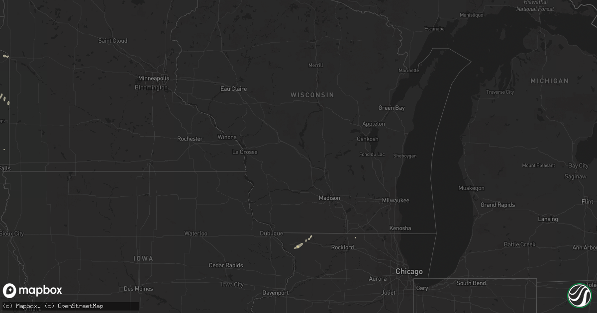
Hail Map in Massachusetts on July 26, 2011
Get this storm
July 26 map
$229
one time, instant access
Download today. No call, no setup
Keep the $229
Bought the map and want the full workflow? Apply the entire $229 to a subscription within 7 days. None of it is wasted.
Every map, not just this one
This buys you this map. Subscription and you get every map we run, in the markets you choose from a few cities to whole states to nationwide. Plus real-time alerts the moment a storm fires.
Contact data
Name, contact info, occupancy, even credit band for addresses in the footprint. You go from where it hit to who to call.
Become the source they trust
Unlimited branding weather history reports on demand. You already have the documented answer ready for the property owner, and you are the one who showed up with it.
Property data and RoofTrace estimates
Pull up any address you have got, its value and the exact code rules for that jurisdiction, straight from One Click Code. Then RoofTrace estimates the squares, pitch, and roof value, priced the way you price.
Storm reports in Massachusetts
Massachusetts
| Date | Description |
|---|---|
| 07/26/20113:55 PM CDT | Many trees down including some into houses on woburn road and main street. Wires down on boston road. |
| 07/26/20113:55 PM CDT | Quarter to half dollar sized hail |
| 07/26/20113:45 PM CDT | Trees and wires down. Street flooding. |
| 07/26/20113:43 PM CDT | A local report indicates 1.00 inch wind near WILBRAHAM |
| 07/26/20113:43 PM CDT | Hundreds of trees down. 10-20 roads closed. Entire town without power. Several trees into buildings. |
| 07/26/20113:42 PM CDT | Trees down across wires |
| 07/26/20113:42 PM CDT | Half dollar 1.25 inch to golf ball 1.75 inch sized hail |
| 07/26/20113:40 PM CDT | Trees down and several road closures. |
| 07/26/20113:37 PM CDT | Boat flipped over on the connecticut river. People on boat rescued and taken to shore. |
| 07/26/20113:36 PM CDT | A local report indicates 1.00 inch wind near SPRINGFIELD |
| 07/26/20113:36 PM CDT | Trees down on locust street. Tree down on house on paramount street with person trapped. Trees down on stuart st... And wellfleet rd. |
| 07/26/20113:36 PM CDT | Trees down on fuller road |
| 07/26/20113:35 PM CDT | Trees down in indian orchard area on berkshire lane and several other streets. Wires down on joanne road. Tree down on house on brewster street. Wires down on memorial |
| 07/26/20113:35 PM CDT | Ping pong sized hail and trees down in the indian orchard section. |
| 07/26/20113:35 PM CDT | *** 1 inj *** trees down on fuller road...the route 33 area....westover road....dolores st...james st....prospect st. Home depot on route 33 has a significant amount of |
| 07/26/20113:35 PM CDT | Tree and wires down blocking middle street |
| 07/26/20113:34 PM CDT | 1 to 1.25 inch hail |
| 07/26/20113:34 PM CDT | Trees down on lyman and prospect streets. Structural damage to already weakened vacant warehouse on lyman st. |
| 07/26/20113:30 PM CDT | Golf ball size hail |
| 07/26/20113:26 PM CDT | Trees down on pontussic and harris streets. |
| 07/26/20113:00 PM CDT | Trees down on candy brook road. Numerous power outages. |
| 07/26/20112:55 PM CDT | Trees and wires down on river road |
| 07/26/20112:55 PM CDT | Trees down at littleville dam...as well as at allen coit...and garfield streets. |
| 07/26/20112:55 PM CDT | Trees and power lines down on skyline trail. |
| 07/26/20112:35 PM CDT | Tree and wires down on river street |
| 07/26/20112:17 PM CDT | Trees down and power outages in the area. |
| 07/26/20112:11 PM CDT | Multiple trees down...tree down on vehicle. |
| 07/26/20112:05 PM CDT | Multiple trees on homes...pecks road. |
| 07/26/20112:03 PM CDT | Tree blocking us route 20 near lebanon ave. |
All States Impacted by Hail Map on July 26, 2011
Cities Impacted by Hail Map on July 26, 2011
- Oakes, ND
- Cozad, NE
- Averill Park, NY
- Roscoe, SD
- Bowdle, SD
- Tolstoy, SD
- Medicine Lake, MT
- Oshkosh, NE
- Hancock, NY
- Birney, MT
- Miles City, MT
- Kinsey, MT
- Ismay, MT
- Farmington, NM
- Blanco, NM
- Bloomfield, NM
- Winnett, MT
- Brusett, MT
- Hankins, NY
- Athens, IL
- Litchfield, IL
- Max, ND
- Athens, LA
- Annapolis, IL
- Letcher, SD
- Lyons, NY
- Busby, MT
- Springfield, MA
- Indian Orchard, MA
- Ludlow, MA
- Chicopee, MA
- Wilbraham, MA
- Otter, MT
- Williamsburg, IA
- Homestead, IA
- Oxford, IA
- Ramsey, IL
- Java, SD
- Hoven, SD
- Otego, NY
- Morris, NY
- Laurens, NY
- Wessington, SD
- Mandaree, ND
- Oxford Junction, IA
- Cannon Falls, MN
- Goodhue, MN
- Agar, SD
- Tioga, ND
- Epping, ND
- Williston, ND
- Ray, ND
- Wolsey, SD
- Huron, SD
- Wauneta, NE
- Avoca, WI
- Salem, UT
- Santaquin, UT
- Payson, UT
- Bingham, NE
- Dalton City, IL
- Fairfield, VT
- East Fairfield, VT
- West Jordan, UT
- West Point, IA
- Ashland, MT
- Forsyth, MT
- Lame Deer, MT
- Saint Lawrence, SD
- Amherst, MA
- Jordan, MT
- Rome, NY
- Delta, UT
- Poplar, MT
- Flaxville, MT
- Harrold, SD
- Andover, NH
- Danbury, NH
- Wilmot, NH
- Big Springs, NE
- Chappell, NE
- East Nassau, NY
- Chadwicks, NY
- Utica, NY
- Sauquoit, NY
- Clinton, NY
- New Hartford, NY
- New Durham, NH
- Sandersville, GA
- Tennille, GA
- Enders, NE
- Tulare, SD
- North Hartland, VT
- Hartland, VT
- Plainfield, NH
- Windsor, NY
- Starlight, PA
- Deposit, NY
- Susquehanna, PA
- Long Eddy, NY
- Saint Libory, NE
- Olin, IA
- Wessington Springs, SD
- Decker, MT
- Cleveland, NY
- Sedgwick, CO
- Julesburg, CO
- Ovid, CO
- Cody, NE
- Milton, NH
- Union, NH
- Acton, ME
- Lebanon, ME
- Milton Mills, NH
- Anamosa, IA
- Rapelje, MT
- Springfield, NH
- What Cheer, IA
- Benson, MN
- Fort Madison, IA
- Stanley, ND
- Cathay, ND
- Hitchcock, SD
- Phelps, NY
- Wyoming, IA
- Akron, CO
- Harvey, ND
- Dalton, MA
- Pittsfield, MA
- West Monroe, NY
- Winner, SD
- Westmoreland, NY
- Decatur, IL
- Mt Zion, IL
- South Jamesport, NY
- Laurel, NY
- Riverhead, NY
- Southampton, NY
- Hampton Bays, NY
- Jamesport, NY
- Mattituck, NY
- Malta, MT
- Farwell, NE
- Sparta, WI
- Lebanon, SD
- Cantrall, IL
- Gilford, NH
- Laconia, NH
- Douglas, ND
- Valentine, NE
- Phoenicia, NY
- Star Lake, NY
- Newton Falls, NY
- Pierpont, SD
- Webster, SD
- Roslyn, SD
- Carlyle, IL
- Patoka, IL
- Vandalia, IL
- Mulberry Grove, IL
- Shobonier, IL
- Wood, SD
- Coventry, CT
- Andover, CT
- Spanish Fork, UT
- Andover, ME
- Ideal, SD
- Winfred, SD
- Ramona, SD
- Madison, SD
- Howard, SD
- Ortonville, MN
- Clinton, MN
- Artesian, SD
- Becket, MA
- Hinsdale, MA
- Middlefield, MA
- Scobey, MT
- Wilmot, SD
- Moweaqua, IL
- Glenarm, IL
- Wildrose, ND
- Cedar Valley, UT
- Kimball, SD
- Oblong, IL
- White Earth, ND
- Ingomar, MT
- Hyannis, NE
- Fort Bliss, TX
- Crow Agency, MT
- Skaneateles, NY
- Auburn, NY
- Vernon, NY
- Benkelman, NE
- Andover, SD
- Langford, SD
- New London, IA
- Mountain Home, UT
- Alton Bay, NH
- Gilmanton Iron Works, NH
- Gilmanton, NH
- Oconee, IL
- Bingham, IL
- Clear Lake, SD
- Goodwin, SD
- Hurdsfield, ND
- Orleans, VT
- West Charleston, VT
- Barton, VT
- Harrisville, NY
- Toronto, SD
- Brandt, SD
- Mount Pleasant, IA
- Merriman, NE
- Ashby, NE
- Water Mill, NY
- Woonsocket, SD
- Springvale, ME
- Parks, NE
- Cocoa, FL
- Jeffersonville, NY
- North Branch, NY
- Hortonville, NY
- Kenoza Lake, NY
- Callicoon, NY
- Swan Lake, NY
- Sheffield, IA
- Dougherty, IA
- Stockton, IL
- Elizabeth, IL
- Trempealeau, WI
- Winona, MN
- Chester, MA
- Huntington, MA
- Mcclusky, ND
- Butte, ND
- Mercer, ND
- Turtle Lake, ND
- Deansboro, NY
- Waterville, NY
- Shapleigh, ME
- Sanford, ME
- Sanbornville, NH
- Cochran, GA
- Volborg, MT
- Champion, NE
- Fort Peck, MT
- Otis, CO
- Yuma, CO
- Carthage, SD
- Taftsville, VT
- Woodstock, VT
- Waterloo, IA
- Dunkerton, IA
- Jesup, IA
- Livingston Manor, NY
- Fremont Center, NY
- Youngsville, NY
- Damascus, PA
- Roscoe, NY
- Equinunk, PA
- Parshall, ND
- Roseglen, ND
- Ryder, ND
- New Lebanon, NY
- East Chatham, NY
- Angela, MT
- Mission, SD
- Haigler, NE
- Hampden, MA
- Monson, MA
- Albany, NY
- Schenectady, NY
- Rhinebeck, NY
- Blossvale, NY
- Camden, NY
- Fulton, SD
- Alexandria, SD
- Eden, SD
- Vivian, SD
- Presho, SD
- Britton, SD
- Peever, SD
- Bowdon, ND
- Fessenden, ND
- Alton, NH
- Bloomington, WI
- Lancaster, WI
- Stitzer, WI
- Fennimore, WI
- Lonsdale, MN
- Lanesborough, MA
- Berkshire, MA
- Stephentown, NY
- Morrisonville, IL
- Pawnee, IL
- Blunt, SD
- Bakersfield, VT
- Jeffersonville, VT
- Fairfax, VT
- Spring Valley, MN
- Wykoff, MN
- Preston, MN
- Bethany, IL
- Findlay, IL
- Plankinton, SD
- Center Barnstead, NH
- Lodgepole, NE
- Spring Green, WI
- Grass Range, MT
- Eastford, CT
- Ashford, CT
- East Longmeadow, MA
- Willington, CT
- Florence, MA
- Somers, CT
- Southampton, MA
- Stafford Springs, CT
- Easthampton, MA
- Holyoke, MA
- South Hadley, MA
- Onida, SD
- Ree Heights, SD
- Highmore, SD
- Rochester, IL
- Whitman, NE
- Gordon, GA
- Rangeley, ME
- Gettysburg, SD
- Delta, IA
- Allerton, IL
- Broadlands, IL
- Homer, IL
- Grenville, SD
- Lake City, SD
- Waubay, SD
- Oswegatchie, NY
- Greenville, NY
- Coeymans Hollow, NY
- Hannacroix, NY
- Ravena, NY
- Alcove, NY
- Frankfort, NY
- Terre Haute, IN
- Westerlo, NY
- Lowell, VT
- New Town, ND
- Amherst, CO
- Castleton On Hudson, NY
- East Greenbush, NY
- Chichester, NY
- Alamo, ND
- Cogswell, ND
- Hecla, SD
- Lodge Grass, MT
- Old Forge, PA
- Duryea, PA
- Pittston, PA
- Spencer, SD
- North Liberty, IA
- Miller, SD
- Arcadia, LA
- Gibsland, LA
- El Paso, TX
- Pierre, SD
- Lower Brule, SD
- Fort Pierce, FL
- Warthen, GA
- Newark, NY
- Palmyra, NY
- Witten, SD
- Gouldsboro, PA
- Moscow, PA
- Slingerlands, NY
- Red Hook, NY
- Moosic, PA
- Dallas, PA
- Wyoming, PA
- Clarks Summit, PA
- Denhoff, ND
- Killdeer, ND
- Watford City, ND
- Iroquois, SD
- Danville, GA
- Champlain, NY
- Carrington, ND
- Drake, ND
- Rensselaer, NY
- Glenmont, NY
- Ellaville, GA
- Claremont, SD
- Groton, SD
- Springfield, IL
- Petersburg, IL
- Oriskany Falls, NY
- Vernon Center, NY
- Great Barrington, MA
- Dublin, GA
- Cavour, SD
- Enfield, NH
- Grantham, NH
- Mcgregor, ND
- Garretson, SD
- Alpena, SD
- Buena Vista, GA
- Hillsboro, IL
- Enfield, CT
- Dayton, ID
- West Springfield, MA
- Corona, SD
- Limon, CO
- Thedford, NE
- Imperial, NE
- Amherst, SD
- Veblen, SD
- Lewellen, NE
- Meredith, NH
- Jeffersonville, GA
- Milton, VT
- Big Stone City, SD
- Prior Lake, MN
- Clayville, NY
- Gann Valley, SD
- Mitchell, SD
- Bath, SD
- Frederick, SD
- Aberdeen, SD
- Bristol, SD
- Houghton, SD
- Columbia, SD
- Immokalee, FL
- Tallula, IL
- Edinburg, IL
- Port Byron, NY
- Weedsport, NY
- Savannah, NY
- Montezuma, NY
- Nassau, NY
- East Schodack, NY
- Anton, CO
- Ross, ND
- Center Junction, IA
- Nephi, UT
- Kite, GA
- Fort Pierre, SD
- East Dublin, GA
- Astoria, SD
- Hendricks, MN
- Macon, GA
- Dudley, GA
- Dexter, GA
- South New Berlin, NY
- Matheson, CO
- Las Cruces, NM
- Nokomis, IL
- Fillmore, IL
- Moravia, NY
- Mechanicsville, IA
- Ipswich, SD
- Irving, IL
- Witt, IL
- Glasgow, MT
- Hinsdale, MT
- Lenox, MA
- Pleasant Mount, PA
- Thompson, PA
- Lakewood, PA
- Union Dale, PA
- Waterville, MN
- Kennebec, SD
- Sidney, IL
- Urbana, IL
- Clyde, NY
- Dodgeville, WI
- Holabird, SD
- Leola, SD
- Westport, SD
- West Sand Lake, NY
- Danvers, MN
- Redstone, MT
- Coolidge, GA
- Ochlocknee, GA
- White Lake, SD
- Odessa, MN
- Cubero, NM
- Ellendale, ND
- Fullerton, ND
- Salem, SD
- Shakopee, MN
- Okreek, SD
- Waterloo, NY
- Mount Vernon, SD
- Camp Hill, AL
- Westfield, MA
- Feeding Hills, MA
- Latham, NY
- Fedora, SD
- Feura Bush, NY
- Selkirk, NY
- Wallace, NE
- Eden, VT
- West Lebanon, NH
- White River Junction, VT
- Bienville, LA
- Storrs Mansfield, CT
- Dagmar, MT
- Wrightsville, GA
- Reynolds, GA
- Stanfordville, NY
- Clinton Corners, NY
- Monticello, IA
- Mount Vernon, IA
- Solon, IA
- Glenfield, ND
- Eustis, NE
- North Bay, NY
- Hardin, MT
- Woodman, WI
- Boscobel, WI
- Mount Hope, WI
- Opelika, AL
- Elkhart, IL
- Mount Pulaski, IL
- Lewistown, IL
- Delmar, NY
- Welch, MN
- Lena, IL
- Lexington, NE
- Elwood, NE
- Lone Rock, WI
- Clark Mills, NY
- Appleton, MN
- Correll, MN
- Havana, IL
- Ipava, IL
- Hawkinsville, GA
- Pontiac, IL
- Belchertown, MA
- Lisbon, IA
- Oran, IA
- Montrose, GA
- Kilkenny, MN
- Weston, GA
- Richland, GA
- Cuthbert, GA
- Estelline, SD
- Winnfield, LA
- McConnell, IL
- Winslow, IL
- Seneca Falls, NY
- Auburn, AL
- Adrian, GA
- Capron, IL
- Poplar Grove, IL
- Cope, CO
- Clarence, IA
- King Ferry, NY
- Genoa, NY
- Holloway, MN


