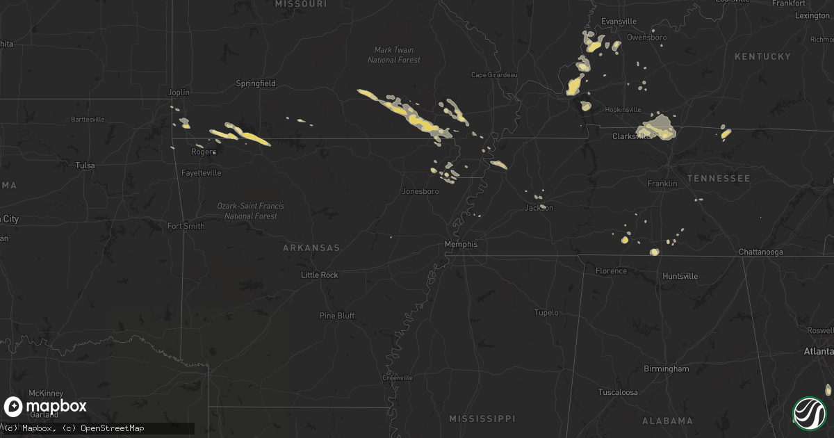
Hail Map in Georgia on August 2, 2012
Get this storm
August 2 map
$229
one time, instant access
Download today. No call, no setup
Keep the $229
Bought the map and want the full workflow? Apply the entire $229 to a subscription within 7 days. None of it is wasted.
Every map, not just this one
This buys you this map. Subscription and you get every map we run, in the markets you choose from a few cities to whole states to nationwide. Plus real-time alerts the moment a storm fires.
Contact data
Name, contact info, occupancy, even credit band for addresses in the footprint. You go from where it hit to who to call.
Become the source they trust
Unlimited branding weather history reports on demand. You already have the documented answer ready for the property owner, and you are the one who showed up with it.
Property data and RoofTrace estimates
Pull up any address you have got, its value and the exact code rules for that jurisdiction, straight from One Click Code. Then RoofTrace estimates the squares, pitch, and roof value, priced the way you price.
Storm reports in Georgia
Georgia
| Date | Description |
|---|---|
| 08/02/20126:37 PM CDT | Trees down on highway 37. |
| 08/02/20126:32 PM CDT | Multiple trees and powerlines down along highway 200. |
| 08/02/20125:30 PM CDT | A tree was reported down on a business at fox brothers barbeque in northeast atlanta. |
| 08/02/20125:30 PM CDT | Media relayed reports of several trees down across northeast atlanta including iverson avenue...hardee street and sinclair avenue. |
| 08/02/20124:22 PM CDT | Liberty county 911 reported a tree down on lee rd and bacon rd. |
| 08/02/20124:15 PM CDT | The liberty county 911 call center reported one tree down near the intersection of highway 119 and highway 84. |
| 08/02/20123:45 PM CDT | The liberty county 911 call center relayed a report of one tree down along highway 119. |
| 08/02/20123:40 PM CDT | Public reported quarter size hail in fort stewart. |
| 08/02/20123:35 PM CDT | One tree down near the intersection of luke road and hw-17. |
| 08/02/20123:30 PM CDT | Jefferson county 911 center reported one tree down near louisville on t e buchanan road. Time is estimated based on radar. |
| 08/02/20123:30 PM CDT | Liberty dispatch reported a tree on a power line in flemington. |
| 08/02/20123:22 PM CDT | Near the intersection of springfield road and old dixie highway. |
| 08/02/20123:00 PM CDT | Several trees blown down on homes and cars throughout the city of dawson. Many power lines were also down...with widespread power outages. |
| 08/02/20122:57 PM CDT | Quarter sized hail reported in dawson and was still falling at 4 pm edt. |
| 08/02/20122:50 PM CDT | Hail up to half dollar size on mock road. |
| 08/02/20122:40 PM CDT | One tree down near the 5700 block of ogeechee road. |
| 08/02/20122:18 PM CDT | Public reported penny to quarter size hail in downtown sylvania near intersection of nimms rd and ogeechee rd. |
| 08/02/20122:05 PM CDT | One tree down on hw-17 near blue jay road. |
| 08/02/20122:04 PM CDT | Marble to half dollar sized hail in pineora relayed by broadcast media. |
| 08/02/20121:59 PM CDT | One tree and power lines down on hw-17 near lambert road. |
| 08/02/20121:50 PM CDT | Near exit 132 on i-16. |
| 08/02/20121:47 PM CDT | One tree down and several large limbs near exit 132 on i-16. |
| 08/02/20121:45 PM CDT | Hail up to the size of ping pong balls in the 1600 block of bay branch road. |
| 08/02/20121:45 PM CDT | Tree down on a house on rommel avenue. Time estimated from radar. |
| 08/02/20121:40 PM CDT | Post office reported 1-inch hail on bunn store road |
| 08/02/20121:40 PM CDT | Post office reported two trees down on shady lane near midville. |
| 08/02/20121:10 PM CDT | Several trees down in town. One large oak tree fell on a mobile home. Very heavy rain also accompanied the storm. 4 feet of standing water closed hwy 280 between mills |
| 08/01/20128:14 PM CDT | Small branches down. |
| 08/01/20128:04 PM CDT | Several trees and powerlines down on the north side of toccoa...ga. Time determined by radar. |
All States Impacted by Hail Map on August 2, 2012
Cities Impacted by Hail Map on August 2, 2012
- Morrisonville, IL
- La Grange, NC
- Vernon, FL
- Kadoka, SD
- Garnett, SC
- Bronwood, GA
- Springfield, TN
- Wallace, NC
- Teachey, NC
- Rincon, GA
- Camilla, GA
- Carthage, NC
- Blackville, SC
- Williston, SC
- Green Pond, SC
- Defuniak Springs, FL
- Polkton, NC
- Peachland, NC
- Guyton, GA
- Soperton, GA
- Glenwood, GA
- Columbia, SC
- Preston, GA
- Wall, SD
- Mission, SD
- Lead, SD
- New Hill, NC
- Cope, SC
- Mills, NE
- Springview, NE
- Cottageville, SC
- Ridgeville, SC
- Dorchester, SC
- Vass, NC
- McCrory, AR
- Colome, SD
- Poplar Bluff, MO
- Neelyville, MO
- Qulin, MO
- Grand Rivers, KY
- Smithland, KY
- Salem, KY
- Burna, KY
- Marion, KY
- Tiline, KY
- Waverly, IL
- Sanford, NC
- Rupert, GA
- Mauk, GA
- Conway, SC
- Lexington, SC
- Central City, KY
- Maceo, KY
- Colby, KS
- Paragould, AR
- Rector, AR
- Senath, MO
- Lucama, NC
- Fremont, NC
- Kenly, NC
- Wilson, NC
- Smithfield, NC
- Selma, NC
- Princeton, NC
- Sharon Springs, KS
- Sundance, WY
- Crane Hill, AL
- Logan, AL
- Arley, AL
- Ivanhoe, NC
- Claxton, GA
- Hope Mills, NC
- Rapid City, SD
- Box Elder, SD
- Ellsworth Afb, SD
- Piedmont, SD
- Robards, KY
- Henderson, KY
- Corydon, KY
- Charlotte, NC
- Matthews, NC
- Danville, AL
- Seabrook, SC
- Yemassee, SC
- Snow Hill, NC
- Nokomis, IL
- Hopewell, VA
- Ramsey, IL
- Bingham, IL
- Seligman, MO
- Golden, MO
- Washburn, MO
- Shell Knob, MO
- Berryville, AR
- Eagle Rock, MO
- Milton, FL
- Cerro Gordo, NC
- Tabor City, NC
- Elsie, NE
- Springfield, CO
- Wingate, NC
- Monroe, NC
- Aynor, SC
- Rose Hill, NC
- Harrells, NC
- Kite, GA
- Oshkosh, NE
- Quinn, SD
- Hoffman, NC
- Pinebluff, NC
- Fleming, GA
- Sylvania, GA
- Millen, GA
- Rocky Ford, GA
- Seneca, MO
- Neosho, MO
- Mount Pleasant, TN
- Jackson, TN
- Sumter, SC
- Gable, SC
- Mayesville, SC
- Wadley, GA
- Marshville, NC
- Harmony, ME
- Moweaqua, IL
- Jarratt, VA
- Deadwood, SD
- Wakefield, VA
- Ivor, VA
- Elberon, VA
- Zuni, VA
- Dendron, VA
- Windsor, VA
- New Underwood, SD
- Scranton, SC
- Coward, SC
- Effingham, SC
- Cheraw, SC
- Lake City, SC
- Lynchburg, SC
- Olanta, SC
- Timmonsville, SC
- Pamplico, SC
- Turbeville, SC
- Rockingham, NC
- Richland, GA
- Lumpkin, GA
- Parrott, GA
- Weston, GA
- Cuthbert, GA
- Abbeville, GA
- Willard, NC
- Monette, AR
- Pikeville, NC
- Interior, SD
- Walstonburg, NC
- Stantonsburg, NC
- Midlothian, VA
- Richmond, VA
- Powhatan, VA
- Moseley, VA
- Humboldt, TN
- Gadsden, TN
- Emporia, VA
- Boyes, MT
- Broadus, MT
- Hammond, MT
- Alzada, MT
- Dexter, MO
- Dudley, MO
- Haleyville, AL
- Rowland, NC
- Hamer, SC
- Dillon, SC
- Little Rock, SC
- Maxton, NC
- Winner, SD
- Ellaville, GA
- Buena Vista, GA
- Statesboro, GA
- Newington, GA
- Kelly, NC
- Beech Island, SC
- Addison, AL
- Vinemont, AL
- Cullman, AL
- Parmelee, SD
- Sparks, NE
- Norris, SD
- Rosebud, SD
- Valentine, NE
- Saint Francis, SD
- Ponce De Leon, FL
- Westville, FL
- Fort Pierre, SD
- Lilesville, NC
- Lampe, MO
- Blue Eye, MO
- Springfield, GA
- Clyo, GA
- Sardis, AL
- Minter, AL
- Pineville, MO
- Anderson, MO
- Bonneau, SC
- Moncks Corner, SC
- Saint Stephen, SC
- Jamestown, SC
- Pinopolis, SC
- Altamont, IL
- Ridgeland, SC
- Morganfield, KY
- Norwood, NC
- Robertsdale, AL
- Nemo, SD
- Elizabethtown, NC
- Clarkton, NC
- Bladenboro, NC
- Hornersville, MO
- Arbyrd, MO
- Louisville, GA
- Fredonia, KY
- Kuttawa, KY
- Calvert City, KY
- Meigs, GA
- Sturgis, KY
- New Haven, IL
- Shawneetown, IL
- Waverly, KY
- Uniontown, KY
- Mount Vernon, IN
- Chappell, NE
- Jacksonville, GA
- Ellsinore, MO
- Waverly, VA
- Newport, NE
- Birch Tree, MO
- Gordon, GA
- Marion, NC
- Prospect, TN
- Black Hawk, SD
- Saint Augustine, FL
- Atkinson, NE
- Jay, OK
- Walterboro, SC
- Fallon, MT
- Pinewood, SC
- Upton, WY
- Moorcroft, WY
- Harviell, MO
- Naylor, MO
- Bailey, NC
- Marston, NC
- Vidalia, GA
- Goldsboro, NC
- Franklin, IL
- Jacksonville, IL
- Leachville, AR
- Lane, SC
- Andrews, SC
- Summerville, SC
- Brighton, TN
- Elm City, NC
- Hortense, GA
- Monument, KS
- Oakley, KS
- Edson, KS
- Winona, KS
- Wing, ND
- Girard, GA
- Bingham, ME
- Dunlap, TN
- Doniphan, MO
- Fairdealing, MO
- Grandin, MO
- Oxly, MO
- Scotland, MD
- Lottsburg, VA
- Henrico, VA
- Boonville, IN
- Cardwell, MO
- Green Forest, AR
- Daphne, AL
- Denmark, SC
- Leland, NC
- Tifton, GA
- Clarksville, TN
- Adams, TN
- Cedar Hill, TN
- Kingstree, SC
- Roseboro, NC
- Salemburg, NC
- Rhine, GA
- Houston, AL
- Newton, GA
- Big Springs, NE
- Venango, NE
- Julesburg, CO
- Murray, KY
- Ridgway, IL
- Junction, IL
- Griffin, GA
- Milner, GA
- Martin, GA
- Toccoa, GA
- Callahan, FL
- Moulton, AL
- Cobb, GA
- Americus, GA
- De Soto, GA
- Leslie, GA
- Byromville, GA
- Cordele, GA
- Vienna, GA
- Alpine, AL
- Folsom, NM
- Ridgedale, MO
- Omaha, AR
- McIntyre, GA
- Saucier, MS
- Gregory, SD
- Cantonment, FL
- Whitesville, KY
- Alcolu, SC
- Clayton, NM
- Felt, OK
- Bentonville, AR
- Rogers, AR
- Seven Springs, NC
- Dudley, NC
- Mount Olive, NC
- Pembroke, GA
- Dawson Springs, KY
- Princeton, KY
- Brownstown, IL
- Garfield, AR
- Smithfield, VA
- Spring Grove, VA
- Stony Creek, VA
- Yale, VA
- Hazlehurst, GA
- Atkinson, NC
- Wasta, SD
- Owanka, SD
- Uvalda, GA
- Lyons, GA
- Hamlet, NC
- Spring Hope, NC
- Middlesex, NC
- Brodnax, VA
- Riceboro, GA
- Leoma, TN
- Lafayette, TN
- Red Boiling Springs, TN
- Green Sea, SC
- Nichols, SC
- Circle, MT
- Round O, SC
- Goldston, NC
- Scotland Neck, NC
- Baxley, GA
- Cadiz, KY
- Eddyville, KY
- Summersville, MO
- Fremont, MO
- Corning, AR
- Van Buren, MO
- Campbell, MO
- Eminence, MO
- Winona, MO
- Pollard, AR
- Gamaliel, KY
- Chester, SC
- Fountain, NC
- Fayetteville, TN
- Dellrose, TN
- Frankewing, TN
- Dawson, GA
- Swansea, SC
- Saint Matthews, SC
- Pitts, GA
- Rochelle, GA
- Brilliant, AL
- Reidsville, GA
- Riegelwood, NC
- Council, NC
- Midway, GA
- Hinesville, GA
- Nesmith, SC
- Blackstock, SC
- Saint Elmo, IL
- Effingham, IL
- Smithville, GA
- Clinton, NC
- Turkey, NC
- Warsaw, NC
- Faison, NC
- Alamo, GA
- Dublin, GA
- Fort Gaines, GA
- Coleman, GA
- Sylacauga, AL
- Verbena, AL
- Marbury, AL
- Oak Grove, AR
- Lisco, NE
- Pensacola, FL
- Westpoint, TN
- Loretto, TN
- Lawrenceburg, TN
- Parma, MO
- Cameron, SC
- Elloree, SC
- Hemingway, SC
- Olar, SC
- Bamberg, SC
- Orrum, NC
- Fairmont, NC
- Fisk, MO
- Leary, GA
- Jackson Springs, NC
- West End, NC
- Fort Mill, SC
- Rock Hill, SC
- Middleburg, FL
- Green Cove Springs, FL
- Oakfield, TN
- Medina, TN
- Sumner, GA
- Ty Ty, GA
- Medora, IL
- Shipman, IL
- Clanton, AL
- Bloomingdale, GA
- Laurel Hill, NC
- Pingree, ND
- Goodman, MO
- Broadwater, NE
- Wolf Point, MT
- Tillman, SC
- Estill, SC
- Pineland, SC
- Rice, VA
- Farmville, VA
- Milan, GA
- Allensville, KY
- Guthrie, KY
- Newton, IL
- Eagle Springs, NC
- Robbins, NC
- Waynesboro, TN
- Franklinton, NC
- Girard, IL
- Sturgis, SD
- Spearfish, SD
- Beulah, WY
- Florence, SC
- Georgetown, GA
- Pine Mountain, GA
- Hamilton, GA
- Newbern, TN
- Dyersburg, TN
- Ridgely, TN
- Pineview, GA
- Russellville, KY
- Wanblee, SD
- Savannah, GA
- Kittrell, NC
- Midville, GA
- Quapaw, OK
- Wyandotte, OK
- Jesup, GA
- Ludowici, GA
- Ellabell, GA
- Dallas, SD
- Bradleyville, MO
- Ava, MO
- Olmstead, KY
- Franklin, KY
- Greenbrier, TN
- Cross Plains, TN
- White House, TN
- Orlinda, TN
- Adairville, KY
- Damascus, GA
- Lumber City, GA
- Cassville, MO
- Charlotte Court House, VA
- Willow Hill, IL
- Farmville, NC
- Macclesfield, NC
- Eastover, SC
- Greenville, KY
- Seagrove, NC
- Fayetteville, NC
- Petersburg, TN
- Eastman, GA
- Moultrie, GA
- Draper, SD
- Winfield, AL
- Guin, AL
- Bernie, MO
- Fair Bluff, NC
- Oneill, NE
- Cooperstown, ND
- Callao, VA
- Lapeer, MI
- Metropolis, IL
- Cordova, SC
- Greenville, NC
- Glenfield, ND
- Wade, NC
- Parkton, NC
- Fort Bragg, NC
- Spring Lake, NC
- Tyler, AL
- New Kent, VA
- Dalzell, SC
- Noble, MO
- Thornfield, MO
- Portageville, MO
- Elberta, AL
- Seminole, AL
- Windsor, IL
- Fillmore, IL
- Oconee, IL
- Elkton, FL
- Jacksonville, FL
- Prattville, AL
- Autaugaville, AL
- Saint George, SC
- Clay, KY
- Brooklet, GA
- Arlington, GA
- Chula, GA
- Burlison, TN
- Eureka Springs, AR
- Hulett, WY
- Hague, VA
- Davison, MI
- Fredonia, KS
- Immokalee, FL
- Aurora, MO
- Harrison, AR
- Lead Hill, AR
- Williamsville, MO
- Wappapello, MO
- Long Valley, SD
- Pine Apple, AL
- Baker, FL
- Fairfield, ND
- Palmyra, IL
- Divernon, IL
- Gainesville, MO
- Pittsfield, IL
- Dudley, GA
- Rockford, AL
- Christiana, TN
- Pike Road, AL
- Falkville, AL
- Stuart, NE
- Garfield, GA
- Twin City, GA
- Portal, GA
- Forsyth, MT
- Bowman, SC
- Owensville, IN
- Mount Carmel, IL
- York, AL
- Livingston, AL
- Disputanta, VA
- Petersburg, VA
- Ailey, GA
- Bethel, NC
- Kensal, ND
- Harvey, LA
- Marrero, LA
- Macedonia, IL
- Burgaw, NC
- Altamont, KS
- Allendale, SC
- Martin, SC
- Jamesville, NC
- Williamston, NC
- Talladega, AL
- Gobler, MO
- Steele, MO
- Orangeburg, SC
- Okreek, SD
- Martin, SD
- Kinsey, MT
- Sacramento, KY
- Island, KY
- Shumway, IL
- Stewardson, IL
- Dunn Center, ND
- Eureka, KS
- Lawrenceville, VA
- Phil Campbell, AL
- Bear Creek, AL
- Williamsburg, VA
- Oakboro, NC
- Adams Run, SC
- Patrick, SC
- Leesburg, GA
- Albany, GA
- Labelle, FL
- Grenville, NM
- Beaverton, AL
- Tarrytown, GA
- Saint Johns, FL
- Fleming Island, FL
- Murrayville, IL
- Raeford, NC
- Wagram, NC
- Cameron, NC
- McRae Helena, GA
- Aberdeen, NC
- Sebree, KY
- Gardendale, AL
- Warrior, AL
- Dunnsville, VA
- Center Cross, VA
- Tappahannock, VA
- Terry, MT
- Lehigh Acres, FL
- Kathleen, GA
- Autryville, NC
- Pooler, GA
- Molino, FL
- Richmond Hill, GA
- Allenhurst, GA
- Fort Stewart, GA
- Jackson, AL
- Grove Hill, AL
- Gays, IL
- New Douglas, IL
- Staunton, IL
- Loris, SC
- Hastings, FL
- Indian Trail, NC
- Midland, NC
- Vancleave, MS
- Sale City, GA
- Pelham, GA
- Sutton, ND
- Okolona, MS
- Castleberry, AL
- Brewton, AL
- Evergreen, AL
- Ulmer, SC
- Morris, GA
- Lake Lure, NC
- Union Mills, NC
- Cynthiana, IN
- New Harmony, IN
- Bellmont, IL
- Poseyville, IN
- Browns, IL
- Griffin, IN
- Freeport, FL
- White Plains, KY
- Nortonville, KY
- Pineville, NC
- Naper, NE
- Edison, GA
- Auburn, KY
- Marmaduke, AR
- Swainsboro, GA
- Puxico, MO
- McGee, MO
- Glennville, GA
- Murfreesboro, TN
- Chesterfield, VA
- Beaufort, SC
- Sheldon, SC
- Robinson, ND
- Chadbourn, NC
- Clarendon, NC
- Oblong, IL
- Maysville, AR
- Stedman, NC
- Ravenel, SC
- Gadsden, SC
- Milan, TN
- Newburgh, IN
- Elkmont, AL
- Lynnville, TN
- Wasola, MO
- Harrington, DE
- Bartow, GA
- Sylvester, GA
- Warm Springs, GA
- Shiloh, GA
- Cave In Rock, IL
- Summerton, SC
- Mulberry Grove, IL
- Smithboro, IL
- Ashburn, GA
- Sycamore, GA
- Chetopa, KS
- Repton, AL
- Carson, VA
- Richland, IN
- Grant, NE
- Wing, AL
- Shorterville, AL
- Abbeville, AL
- Palm Coast, FL
- Palatka, FL
- Rembert, SC
- Hanover, VA


