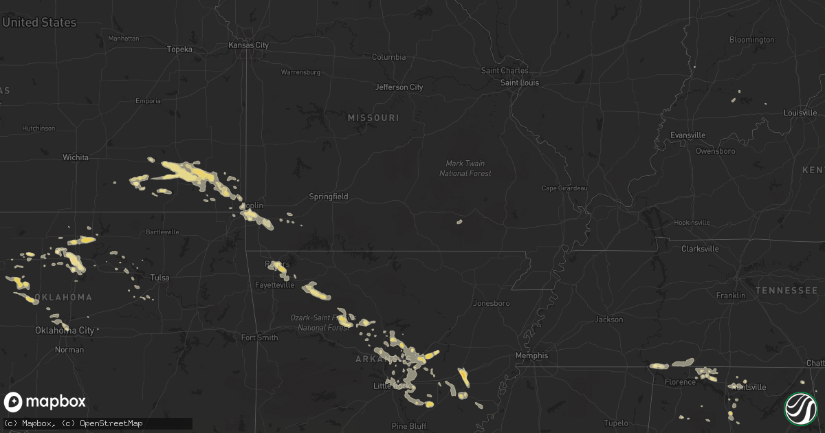
Hail Map in Arkansas on August 8, 2011
Get this storm
August 8 map
$229
one time, instant access
Download today. No call, no setup
Keep the $229
Bought the map and want the full workflow? Apply the entire $229 to a subscription within 7 days. None of it is wasted.
Every map, not just this one
This buys you this map. Subscription and you get every map we run, in the markets you choose from a few cities to whole states to nationwide. Plus real-time alerts the moment a storm fires.
Contact data
Name, contact info, occupancy, even credit band for addresses in the footprint. You go from where it hit to who to call.
Become the source they trust
Unlimited branding weather history reports on demand. You already have the documented answer ready for the property owner, and you are the one who showed up with it.
Property data and RoofTrace estimates
Pull up any address you have got, its value and the exact code rules for that jurisdiction, straight from One Click Code. Then RoofTrace estimates the squares, pitch, and roof value, priced the way you price.
Storm reports in Arkansas
Arkansas
| Date | Description |
|---|---|
| 08/08/20116:57 PM CDT | Quarter sized hail was reported near interstate 430 and crystal hill road. |
| 08/08/20115:58 PM CDT | A large tree limb was blown down. |
| 08/08/20115:50 PM CDT | Limbs were blown down at walnut grove. |
| 08/08/20114:32 PM CDT | Tree limbs were blown down. |
| 08/08/20113:50 PM CDT | Large trees down due to thunderstorm winds. |
| 08/08/20113:50 PM CDT | Large trees blown down due to thunderstorms. |
| 08/08/20113:33 PM CDT | Numerous large tree limbs broken in area. Estimated 50-60 mph gusts. |
| 08/08/20113:17 PM CDT | 2 to 3 power poles snapped due to thunderstorm winds. |
| 08/08/20112:44 PM CDT | 4-6 inch diameter tree limbs blown across the road. Spotter estimates 70 mph wind. |
| 08/08/20112:42 PM CDT | A local report indicates 1.00 inch wind near 3 E ROGERS |
| 08/07/20118:43 PM CDT | A tree was blown down about a mile north of the highway 79/49 junction. |
| 08/07/20118:30 PM CDT | Power lines were blown down. |
| 08/07/20118:15 PM CDT | Power lines were blown down. |
| 08/07/20118:00 PM CDT | Trees were blown down. |
| 08/07/20117:52 PM CDT | Trees were blown down. |
| 08/07/20117:52 PM CDT | Trees were blown down. |
| 08/07/20117:50 PM CDT | A local report indicates 70 MPH wind near CARLISLE |
| 08/07/20117:10 PM CDT | Off duty military forecaster estimated 60 mph winds and a limb down. |
All States Impacted by Hail Map on August 8, 2011
Cities Impacted by Hail Map on August 8, 2011
- Metamora, IL
- East Peoria, IL
- Chillicothe, IL
- Dunlap, IL
- Peoria, IL
- Mossville, IL
- Edelstein, IL
- West Liberty, KY
- Ohio, IL
- Princeton, IL
- Malden, IL
- La Moille, IL
- Crawfordville, GA
- Bird City, KS
- Oklahoma City, OK
- Elk City, KS
- Elwood, NE
- Geneseo, IL
- Atkinson, IL
- Beebe, AR
- Searcy, AR
- Center Ridge, AR
- Palisade, NE
- Wauneta, NE
- Riverton, NE
- Smith Center, KS
- Lake Wales, FL
- Stinnett, KY
- Newcastle, WY
- Monett, MO
- Walton, IN
- Mount Vernon, AR
- Lebanon Junction, KY
- Boston, KY
- Lafayette, IN
- Howard, KS
- Grenola, KS
- Moline, KS
- Brady, NE
- Maxwell, NE
- Harpersville, AL
- Childersburg, AL
- Oswego, KS
- Altamont, KS
- Gillette, WY
- Monument, KS
- Beeler, KS
- Savannah, GA
- Seneca, MO
- Okarche, OK
- Colby, KS
- Oakley, KS
- Tonkawa, OK
- Trenton, NE
- Stratton, NE
- Ramer, AL
- Pawnee, OK
- Lancaster, KY
- Wilmore, KY
- Moro, AR
- Brinkley, AR
- Aubrey, AR
- Wheatley, AR
- Lyons, GA
- Clinton, IA
- Bryant, IA
- Athens, AL
- Rogersville, AL
- Bee Branch, AR
- Damascus, AR
- Humnoke, AR
- Humphrey, AR
- Stuttgart, AR
- Duluth, MN
- Cloquet, MN
- Hennessey, OK
- Ames, OK
- Metter, GA
- Neosho, MO
- Morocco, IN
- Rensselaer, IN
- Brook, IN
- Galesburg, KS
- Erie, KS
- Thayer, KS
- Parsons, KS
- Saint Paul, KS
- Kingfisher, OK
- Okeene, OK
- Prophetstown, IL
- Tampico, IL
- McRae, AR
- Des Arc, AR
- Ward, AR
- Hickory Plains, AR
- Carlisle, AR
- Huntsville, AR
- Champion, NE
- West Point, MS
- Aberdeen, MS
- Liberty, IN
- Gove, KS
- Quinter, KS
- Bristow, OK
- Kellyville, OK
- Tryon, NE
- North Platte, NE
- Lemoyne, NE
- Keystone, NE
- Ogallala, NE
- Joplin, MO
- Bennett, IA
- New Liberty, IA
- Heflin, AL
- Woodland, AL
- De Valls Bluff, AR
- Holly Grove, AR
- Clarendon, AR
- Edison, GA
- Cuthbert, GA
- Ness City, KS
- Jetmore, KS
- Eustis, NE
- Hawkinsville, GA
- Unadilla, GA
- Baldwin, IA
- Lebanon, NE
- Levant, KS
- Hickory Flat, MS
- Potts Camp, MS
- Christiana, TN
- Falkville, AL
- Hartselle, AL
- Soperton, GA
- Rockledge, GA
- Rankin, IL
- Frankfort, KY
- Fort Gay, WV
- Louisa, KY
- Rock Falls, IL
- Mitchell, GA
- Bardstown, KY
- Prattville, AL
- Princeville, IL
- Montgomery, AL
- Ashland, MS
- Senoia, GA
- Madrid, NE
- Holly Springs, MS
- Macon, GA
- Gray, GA
- Williamsport, IN
- West Lebanon, IN
- Collinwood, TN
- Alvin, IL
- Rossville, IL
- Henning, IL
- Paxton, NE
- Elsie, NE
- Genoa, WV
- Fort Stewart, GA
- Richmond Hill, GA
- Vidalia, GA
- Saginaw, MN
- Warrenton, GA
- Camak, GA
- Norwood, GA
- Moultrie, GA
- Funston, GA
- Farragut, TN
- Louisville, TN
- Knoxville, TN
- Moorefield, NE
- Booneville, KY
- East Dublin, GA
- Fitzpatrick, AL
- Hornsby, TN
- Pocahontas, TN
- Bethel Springs, TN
- Selmer, TN
- Coxs Creek, KY
- Shepherdsville, KY
- Talladega, AL
- Loveland, OH
- Tiplersville, MS
- Walnut, MS
- Lenora, KS
- Cambridge, IL
- Haxtun, CO
- Fleming, CO
- Iliff, CO
- Lagrange, GA
- Parks, NE
- Fall River, KS
- Cobbtown, GA
- Haleyville, AL
- Phil Campbell, AL
- Gibson, GA
- Norton, KS
- Hill City, KS
- Lahoma, OK
- Carrier, OK
- Cissna Park, IL
- Arthur, NE
- Hayes Center, NE
- Girard, KS
- Cherokee, KS
- Pittsburg, KS
- Arlington, GA
- Granby, MO
- Barbourville, KY
- Bryants Store, KY
- Gate City, VA
- Brimfield, IL
- Hanna City, IL
- Edwards, IL
- Myrtle, MS
- New Albany, MS
- Morrison, IL
- Thomson, IL
- Fulton, IL
- Mary Alice, KY
- Harlan, KY
- Pelsor, AR
- Gordon, WI
- Witts Springs, AR
- Hector, AR
- Minong, WI
- Solon Springs, WI
- Hayward, WI
- Elko, GA
- Pineview, GA
- Springfield, KY
- Lebanon, KY
- Toone, TN
- Medon, TN
- Hindsville, AR
- Winona, KS
- Benkelman, NE
- Brewster, KS
- Imperial, NE
- McDonald, KS
- Saint Francis, KS
- Black Hawk, SD
- Piedmont, SD
- Amory, MS
- Rogers, AR
- Lowell, AR
- Funk, NE
- Holdrege, NE
- Fairmount, GA
- Ranger, GA
- Decatur, AL
- Witter, AR
- Ponca, AR
- Kingston, AR
- Saltillo, MS
- Guntown, MS
- Benedict, KS
- Fredonia, KS
- Neodesha, KS
- Altoona, KS
- Sandersville, GA
- Ochlocknee, GA
- Thomasville, GA
- Cairo, GA
- Kingsport, TN
- Gothenburg, NE
- Middleton, TN
- Camilla, GA
- Coal Valley, IL
- Orion, IL
- Osco, IL
- Milan, IL
- Lynn Center, IL
- Andover, IL
- Coggon, IA
- Central City, IA
- Center Point, IA
- Walker, IA
- Lexington, AL
- Goodwater, AL
- Erie, IL
- Lyndon, IL
- Fenton, IL
- Connersville, IN
- Rushville, IN
- Falmouth, IN
- Carthage, IN
- Knightstown, IN
- Bolivar, TN
- Esko, MN
- Greenbrier, AR
- Quitman, AR
- Sibley, IL
- Cullman, AL
- Dixon, IA
- Irvine, KY
- Utica, KS
- Dighton, KS
- Madison, AL
- Mays, IN
- Brownsville, IN
- Arlington, IN
- Greenfield, IN
- Talmoon, MN
- Deer River, MN
- Dublin, GA
- Perry, OK
- Peru, IN
- Bunker Hill, IN
- Montezuma, GA
- Oglethorpe, GA
- Stapleton, NE
- Tipton, IA
- Stockton, IA
- Wilcox, NE
- Bigfork, MN
- Marcell, MN
- Kenansville, FL
- Galena, KS
- Hazen, AR
- Logansport, IN
- Dover, AR
- Monticello, IA
- Hopkinton, IA
- Covington, KY
- Ft Mitchell, KY
- Silver Grove, KY
- Newport, KY
- Fort Thomas, KY
- Cincinnati, OH
- Latonia, KY
- Wilton, IA
- Hattieville, AR
- Cleveland, AR
- Fort Benning, GA
- Wood Lake, MN
- Maquoketa, IA
- Charlotte, IA
- Goose Lake, IA
- Palo, IA
- Cedar Rapids, IA
- Van Orin, IL
- Willisburg, KY
- Mackville, KY
- Bell Buckle, TN
- Beechgrove, TN
- Superior, WI
- Bloomington, NE
- Anderson, AL
- Clinton, AR
- London, KY
- Dadeville, AL
- Jacksons Gap, AL
- Walkersville, WV
- Napier, WV
- Ireland, WV
- Jewell, GA
- Louisville, GA
- Avera, GA
- Jeffersonville, GA
- Mason, WI
- Sherwood, AR
- Earlville, IL
- Sheridan, IL
- Leland, IL
- Waynesboro, TN
- Lawrenceburg, TN
- Buena Vista, GA
- West Branch, IA
- Enid, OK
- Franklin, NE
- Cherryvale, KS
- Chanute, KS
- Saint Charles, MN
- Dover, MN
- Plainview, MN
- Mableton, GA
- Austell, GA
- Springdale, AR
- Higginson, AR
- Griffithville, AR
- Sparks, GA
- Lenox, GA
- Chadron, NE
- Reidsville, GA
- Big Stone Gap, VA
- Scotland, AR
- Perry, FL
- Naponee, NE
- Iron City, TN
- England, AR
- Parthenon, AR
- Dayton, IN
- Meigs, GA
- Walnut, IL
- Morgan, GA
- Ponca City, OK
- Langworthy, IA
- Anamosa, IA
- Mount Judea, AR
- Meno, OK
- Jacksonville, AR
- Vinemont, AL
- Deer, AR
- Mount Vernon, KY
- Serena, IL
- Springfield, GA
- Rincon, GA
- Blakely, GA
- Preston, IA
- Spragueville, IA
- Scott, AR
- El Paso, AR
- North Little Rock, AR
- Wabbaseka, AR
- Lonoke, AR
- Rose Bud, AR
- Cabot, AR
- Maumelle, AR
- Austin, AR
- Vilonia, AR
- Garner, AR
- Little Rock, AR
- Enola, AR
- Keo, AR
- Romance, AR
- Columbus, KS
- McRae Helena, GA
- Alpine, AL
- Farnam, NE
- Delmar, IA
- Jerusalem, AR
- Woodbury, GA
- Saint Johns, FL
- Orlando, OK
- Wilsonville, NE
- Bartley, NE
- Williamsburg, OH
- Batavia, OH
- Jakin, GA
- Moulton, AL
- Gridley, IL
- Flanagan, IL
- Quapaw, OK
- Geneva, AL
- Newburgh, NY
- Marlboro, NY
- Carlton, MN
- Abbeville, AL
- Martinton, IL
- Glenwood, GA
- Orlando, WV
- Burnsville, WV
- Midway, AL
- Ely, IA
- Freeport, FL
- Atwood, KS
- Mcloud, OK
- Meeker, OK
- Lexa, AR
- Billings, OK
- Scammon, KS
- McCune, KS
- Mound Valley, KS
- Longton, KS
- West Mineral, KS
- Dennis, KS
- Laura, IL
- Elmwood, IL
- Williamsfield, IL
- Trivoli, IL
- Jasper, IN
- Dubois, IN
- Menlo, GA
- Hamilton, MS
- Manchester, KY
- Falkner, MS
- Ripley, MS
- Fayetteville, AR
- Cave Springs, AR
- Bentonville, AR
- Donahue, IA
- Mechanicsville, IA
- Warner Robins, GA
- Byron, GA
- Albany, GA
- De Witt, IA
- Samson, AL
- Rydal, GA
- Waleska, GA
- Waterloo, AL
- Watonga, OK
- Hitchcock, OK
- McCook, NE
- Donovan, IL
- Lake City, FL
- Columbus, GA
- Huntsville, TN
- Pelham, GA
- Verona, MO
- Pierce City, MO
- Aurora, MO
- Harvest, AL
- Sapulpa, OK
- Flomaton, AL
- Mendota, IL
- Arlington, IL
- Stanwood, IA
- Loretto, TN
- Saint Joseph, TN
- Savannah, TN
- Sanderson, FL
- Dahinda, IL
- Hazlehurst, GA
- Avon, IL
- Moreland, GA
- Dahlonega, GA
- Dawsonville, GA
- Brookville, IN
- Metamora, IN
- Oaktown, IN
- Beaverville, IL
- Belview, MN
- Clarksdale, MS
- Richland, GA
- Red Rock, OK
- Atkins, IA
- Shellsburg, IA
- Lithonia, GA
- Cordell, OK
- Chatsworth, GA
- Norcatur, KS
- Cambridge, NE
- Eastman, GA
- Dry Branch, GA
- Fort Mitchell, AL
- Scottsbluff, NE
- Garber, OK
- Milledgeville, GA
- Morris, IL
- Pine Mountain, GA
- Wrenshall, MN
- Lake Nebagamon, WI
- Onslow, IA
- Prentice, WI
- Murphy, NC
- Rapid City, SD
- Osage, OK
- Baxter Springs, KS
- Riverton, KS
- Jacobson, MN
- Douglas, OK
- Fairmont, OK
- Max, MN
- Wirt, MN
- Otterbein, IN
- West Lafayette, IN
- Elkmont, AL
- Ulm, AR
- Covington, OK
- Wetumpka, AL
- Middletown, OH
- Huntsville, AL
- Dumas, MS
- Henry, IL
- Bradford, IL
- Putnam, IL
- Belden, MS
- Blue Springs, MS
- Weatherford, OK
- Hay Springs, NE
- Kankakee, IL
- Wessington Springs, SD
- Alpena, SD
- Mitchell, NE
- Varna, IL
- Gordon, GA
- Cypress Inn, TN
- Westpoint, TN
- Florence, AL
- Orlando, KY
- Bloomingdale, GA
- Sparta, NC
- Ennice, NC
- Ashkum, IL
- Crawfordville, FL
- Melvin, IL
- Zumbrota, MN
- Bradyville, TN
- Shelbyville, TN
- Conway, AR
- Plumerville, AR
- Wooster, AR
- Springfield, AR
- Mounds, OK
- Lutts, TN
- Winchester, KY
- Franklin, OH
- Lebanon, OH
- Weir, KS
- Stockville, NE
- Corbin, KY
- Stark City, MO
- Stella, MO
- O'Brien, FL
- Severy, KS
- Hildreth, NE
- Republican City, NE
- Two Harbors, MN
- Cordova, AL
- Defuniak Springs, FL
- Nardin, OK
- Independence, KS
- Byromville, GA
- Terlton, OK
- Cleveland, OK
- Valley, AL
- Salem, AL
- Hamilton, GA
- Sabula, IA
- Hibbing, MN
- Pembroke, GA
- Maramec, OK
- Redwood Falls, MN
- Port Wing, WI
- Chaplin, KY
- Lawrenceburg, KY
- Midway, GA
- Lily, KY
- Salt Lick, KY
- Somerset, KY
- Liberty, KY
- Damascus, GA
- Newton, GA
- Bloomfield, KY
- Hominy, OK
- Venango, NE
- Cascade, IA
- Jackson, TN
- Lodgepole, NE
- Luther, OK
- Pavo, GA
- Hunter, OK
- Lowndesboro, AL
- Waverly, AL
- Lulu, FL
- Kewanee, IL
- Annawan, IL
- Ralston, OK
- Fairfax, OK
- Milltown, IN
- Tellico Plains, TN
- Drumright, OK
- Mannford, OK
- Shorterville, AL
- Killen, AL
- Camp Hill, AL
- Mayo, FL
- Jackson, KY
- Etowah, TN
- Lucien, OK
- Yukon, OK
- Keavy, KY
- Evergreen, AL
- Mathews, AL
- Elk Falls, KS
- Nancy, KY
- Peru, IL
- Buffalo Gap, SD
- Sparland, IL
- Coolidge, GA
- Ashland, WI
- Danville, GA
- Atalissa, IA
- Jasper, AL
- Danforth, IL
- Morrison, TN
- Kathleen, GA
- Michie, TN
- Flat Rock, AL
- Mulberry, IN
- Harrodsburg, KY
- Waverly, WV
- Saint Marys, WV
- Marietta, OH
- Wyandotte, OK
- Grissom Arb, IN
- Onward, IN
- Miami, IN
- Royal Center, IN
- Galveston, IN
- Westpoint, IN
- Nauvoo, AL
- Garnett, SC
- Clyo, GA
- Frenchburg, KY
- Pooler, GA
- Baldwyn, MS
- Chenoa, IL
- New Bedford, IL
- Leary, GA
- Ringwood, OK
- Lamont, OK
- Pinehurst, GA
- Martin, KY
- Fort Blackmore, VA
- Wilmington, IL
- Amelia, OH
- Somerville, AL
- Indianola, NE
- Sedan, KS
- Eureka, IL
- Roanoke, IL
- Union Springs, AL
- Talbotton, GA
- Morrison, OK
- Davenport, IA
- Blue Grass, IA
- Addison, AL
- Waddy, KY
- Waukomis, OK
- Louisville, KY
- Hoopeston, IL
- Ramer, TN
- Lester, AL
- Cusseta, AL
- Opelika, AL
- Buffalo, WY
- Solgohachia, AR
- Curtis, NE
- Wellborn, FL
- Mount Eden, KY
- Carbon Hill, AL
- Eldridge, AL
- Blue Mountain, MS
- Wartrace, TN
- Burden, KS
- New Brockton, AL
- Crestview, FL
- Phillips, WI
- Springfield, MN
- Mount Orab, OH
- Tanner, AL
- Piedmont, OK
- Edmond, OK
- Fleming, GA
- Lafayette, AL
- Marvell, AR
- Poplar Grove, AR
- East Bernstadt, KY
- Mount Washington, KY
- Fremont, MO
- Kellyton, AL
- Alexander City, AL
- Rockford, AL
- Port Wentworth, GA
- Chadwick, IL
- Monmouth, IA
- Oxford Junction, IA
- Lost Nation, IA
- Hogansville, GA
- Westville, FL
- Thomson, GA
- Mount Ayr, IN
- Watseka, IL
- Olivehill, TN


