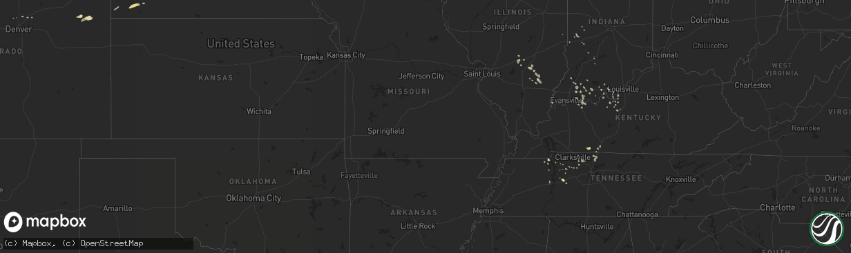
Hail Map in North Carolina on August 23, 2014
The weather event in North Carolina on August 23, 2014 includes Hail map. 13 states and 317 cities were impacted and suffered possible damage. The total estimated number of properties impacted is 0.
Want more than just the map?
Turn this storm into a full workflow.
- Owner + property data so you know who to knock
- OnDemand branded weather history reports to win the "did we even have hail?" argument
- RoofTrace estimate so reps stop guessing numbers at the door
Bought this map? Upgrade within 7 days and we'll credit the $230. (10-15 min setup call)
Hail
0
Estimated number of impacted properties by a 1.00" hail or larger0
Estimated number of impacted properties by a 1.75" hail or larger0
Estimated number of impacted properties by a 2.50" hail or largerStorm reports in North Carolina
North Carolina
| Date | Description |
|---|---|
| 08/23/20145:21 PM CDT | Tree down on barker ten mile road near rozier siding road. Time estimated based on radar. |
| 08/23/20145:21 PM CDT | Tree down at barker ten mile road near russ road. Time estimated based on radar. |
| 08/23/20145:19 PM CDT | Shutters blown off house and storage shed shifted on its foundation at robert bessie road near alton b road. Time estimated based on radar. |
| 08/23/20144:57 PM CDT | Tree down at mcmillan siding road near smith farm road. Time estimated based on radar. |
| 08/23/20144:40 PM CDT | Tree down along anderson creek school road. Time estimated. |
| 08/23/20143:45 PM CDT | Tree down on darroch road and farrar dairy road |
| 08/23/20143:40 PM CDT | Tree down along anderson creek school road. Time estimated. |
All States Impacted by Hail Map on August 23, 2014
Cities Impacted by Hail Map on August 23, 2014
- White River, SD
- Lafayette, CO
- Louisville, CO
- Pipestone, MN
- Ruthton, MN
- Inverness, FL
- Wauneta, NE
- Palisade, NE
- Benkelman, NE
- Louisville, KY
- Elizabeth, IN
- Arcadia, NE
- Russellville, KY
- Adairville, KY
- Yankton, SD
- Mission Hill, SD
- Viborg, SD
- Irene, SD
- Hurley, SD
- Volin, SD
- Stockport, IA
- Yuma, CO
- Otis, CO
- Benson, MN
- Kimball, SD
- Vandalia, IL
- Trent, SD
- Burke, SD
- Platte, SD
- Anamosa, IA
- McEwen, TN
- Only, TN
- Stendal, IN
- Oakland City, IN
- Winslow, IN
- Fairfax, SD
- Corsica, SD
- Lake Andes, SD
- Armour, SD
- Spencer, NE
- Mount Vernon, SD
- Stickney, SD
- Geddes, SD
- Kingston Mines, IL
- Manito, IL
- Glasford, IL
- Mapleton, IL
- Ord, NE
- Pleasant View, TN
- Milltown, IN
- Leavenworth, IN
- Wakonda, SD
- Stewart, TN
- Chappell, NE
- Oshkosh, NE
- Erin, TN
- Old Town, FL
- Ashland City, TN
- Chapmansboro, TN
- Erie, CO
- Mount Vernon, IN
- Atkinson, NE
- Avon, MN
- Dumont, MN
- Ramsey, IL
- Atalissa, IA
- West Liberty, IA
- Wood, SD
- Shobonier, IL
- Alma, IL
- Starbuck, MN
- Elizabethtown, KY
- Rineyville, KY
- Elkton, SD
- Dale, IN
- Ferdinand, IN
- Laconia, IN
- Guttenberg, IA
- Garnavillo, IA
- Tyndall, SD
- Taylor Ridge, IL
- Illinois City, IL
- Terre Haute, IN
- Bridgeport, NE
- Birdseye, IN
- Bristow, IN
- Rushville, NE
- Hay Springs, NE
- Buchanan, TN
- Ekron, KY
- Brandenburg, KY
- Madison, SD
- Plainview, NE
- Pierce, NE
- Toulon, IL
- Greencastle, IN
- San Mateo, FL
- Dunlap, IL
- Osage, IA
- Osakis, MN
- Cairo, NE
- Montrose, SD
- Nunnelly, TN
- Saint Edward, NE
- Springville, TN
- Cisne, IL
- Geff, IL
- Ethan, SD
- Gainesville, FL
- Alachua, FL
- Vine Grove, KY
- Lena, IL
- Dunnellon, FL
- Ocala, FL
- Hendersonville, TN
- Cottontown, TN
- Portland, TN
- White House, TN
- New Middletown, IN
- Corydon, IN
- Velpen, IN
- Fairfield, IA
- Pekin, IL
- Bonesteel, SD
- Bedford, IN
- Haigler, NE
- Parks, NE
- Mills, NE
- Kinmundy, IL
- Xenia, IL
- Broadwater, NE
- Gentryville, IN
- Parker, SD
- Richland, IN
- Milan, IL
- Sherrard, IL
- Aledo, IL
- Reynolds, IL
- Fort Lupton, CO
- Brighton, CO
- Saint Cloud, MN
- Saint Joseph, MN
- Saint Paul, NE
- Williston, FL
- Archer, FL
- Scotia, NE
- Greeley, NE
- Keenesburg, CO
- Cross Plains, TN
- Petersburg, IN
- White Springs, FL
- Freeport, IL
- De Smet, SD
- Carthage, SD
- Owensboro, KY
- Akron, CO
- Brownstown, IL
- Walcott, IA
- Blue Grass, IA
- Stockton, IA
- Vermillion, SD
- Gayville, SD
- Dannebrog, NE
- Olmstead, KY
- West Point, KY
- Guston, KY
- Charlotte, TN
- Naper, NE
- Altenburg, MO
- Jackson, MO
- Franklin, KY
- Holladay, TN
- Rockville, IN
- Rinard, IL
- Gibbon, NE
- Chamberlain, SD
- Saint Meinrad, IN
- West Point, NE
- Parkston, SD
- Kearney, NE
- Lewisport, KY
- Maceo, KY
- Wellfleet, NE
- Stuart, NE
- Louisville, IL
- Flora, IL
- Rockwell, IA
- Nunda, SD
- Arlington, SD
- Ramona, SD
- Morriston, FL
- Lynnville, IN
- Boonville, IN
- Mason City, IA
- Culbertson, NE
- Hayes Center, NE
- Batavia, IA
- Oakville, IA
- Park Ridge, IL
- Chicago, IL
- English, IN
- Birmingham, IA
- Perryville, MO
- Neligh, NE
- Adams, TN
- Paris, TN
- Huron, SD
- Ravenna, NE
- Sims, IL
- Hudson, CO
- Paris, IL
- Palatine, IL
- Rolling Meadows, IL
- Arlington Heights, IL
- Brazil, IN
- Tennyson, IN
- Rockport, IN
- Grandview, IN
- Chrisney, IN
- Battletown, KY
- Letcher, SD
- Bloomfield, IN
- Centerpoint, IN
- Bayard, NE
- Edgemont, SD
- Davis, SD
- Floral City, FL
- Chadron, NE
- Pukwana, SD
- Princeville, IL
- Brimfield, IL
- Flandreau, SD
- Edgewood, IL
- Farina, IL
- Albion, NE
- North Loup, NE
- Oelrichs, SD
- Waverly, TN
- Cedar Hill, TN
- Parkton, NC
- Saint Pauls, NC
- Rosedale, IN
- Muldraugh, KY
- Elmwood, IL
- Spencer, SD
- Cold Spring, MN
- Springfield, TN
- New Boston, IL
- Freeman, SD
- Marion, SD
- Payneville, KY
- Rhodelia, KY
- Bowling Green, IN
- Reddick, FL
- Trivoli, IL
- Scotland, SD
- Elgin, NE
- Oakdale, NE
- Mitchell, SD
- Tennessee Ridge, TN
- Herman, MN
- La Crosse, IN
- San Pierre, IN
- Lamar, IN
- Fullerton, NE
- Keenes, IL
- Tell City, IN
- Stockton, IL
- Irvington, KY
- Custer, KY
- Fairfield, IL
- Hillsboro, IA
- Lone Tree, IA
- Nichols, IA
- Tremont, IL
- Green Valley, IL
- Bloomington, IN
- Springville, IN
- Crofton, NE
- Lennox, SD
- Chancellor, SD
- Huntingburg, IN
- Burlington, IA
- Palmer, NE
- Woodburn, KY
- Bowling Green, KY
- Marengo, IN
- Leola, SD
- Salem, SD
- Vanleer, TN
- Dickson, TN
- Cedar Rapids, NE
- Belgrade, NE
- Hurricane Mills, TN
- Iuka, IL
- Osmond, NE
- Cannelton, IN
- Big Sandy, TN
- Sartell, MN
- Rice, MN
- Loup City, NE
- Canistota, SD
- Bridgewater, SD
- La Fayette, IL
- West Burlington, IA
- Gladstone, IL
- Biggsville, IL
- Radcliff, KY
- Saint Libory, NE
- Fort Knox, KY
- Bassett, NE
- Newport, NE
- Clarksville, TN
- Cumberland Furnace, TN
- Dubois, IN
- Jasper, IN
- Volga, SD


