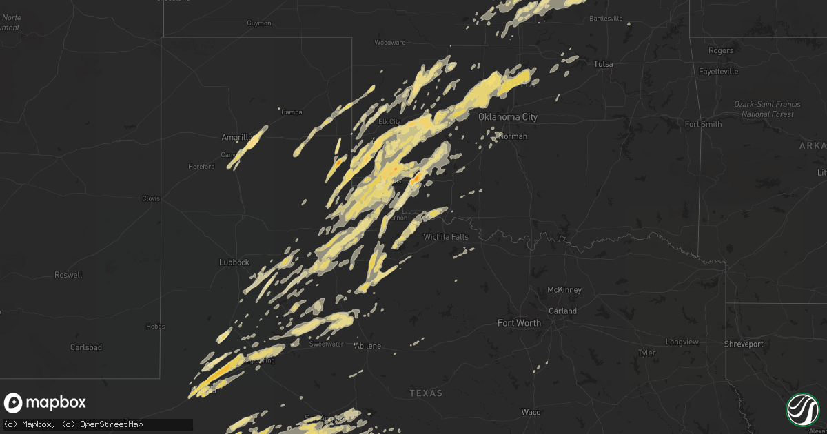
Hail Map in Texas on November 7, 2011
Get this storm
November 7 map
$229
one time, instant access
Download today. No call, no setup
Keep the $229
Bought the map and want the full workflow? Apply the entire $229 to a subscription within 7 days. None of it is wasted.
Every map, not just this one
This buys you this map. Subscription and you get every map we run, in the markets you choose from a few cities to whole states to nationwide. Plus real-time alerts the moment a storm fires.
Contact data
Name, contact info, occupancy, even credit band for addresses in the footprint. You go from where it hit to who to call.
Become the source they trust
Unlimited branding weather history reports on demand. You already have the documented answer ready for the property owner, and you are the one who showed up with it.
Property data and RoofTrace estimates
Pull up any address you have got, its value and the exact code rules for that jurisdiction, straight from One Click Code. Then RoofTrace estimates the squares, pitch, and roof value, priced the way you price.
Storm reports in Texas
Texas
| Date | Description |
|---|---|
| 11/07/20115:42 PM CST | A local report indicates 1.75 inch wind near 5 W CLAUDE |
| 11/07/20115:37 PM CST | A local report indicates 2.00 inch wind near 10 W CLAUDE |
| 11/07/20114:55 PM CST | Two trees down. Time estimated. |
| 11/07/20114:31 PM CST | A local report indicates 1.10 inch wind near WELLINGTON |
| 11/07/20114:30 PM CST | A local report indicates 1.75 inch wind near WELLINGTON |
| 11/07/20114:28 PM CST | A local report indicates 1.00 inch wind near WELLINGTON |
| 11/07/20114:25 PM CST | A local report indicates 1.00 inch wind near 1 S WELLINGTON |
| 11/07/20114:12 PM CST | A local report indicates 1.25 inch wind near 7 E CANYON |
| 11/07/20114:17 AM CST | A local report indicates 1.00 inch wind near LOWAKE |
| 11/07/20114:13 AM CST | A local report indicates 1.00 inch wind near VANCOURT |
| 11/07/20113:50 AM CST | A local report indicates 61 MPH wind near 1 ESE WALL |
| 11/07/20111:35 AM CST | Indicated tree limbs down. |
| 11/06/20119:55 PM CST | Reported by sheriffs deputy on caprock. |
| 11/06/20117:25 PM CST | Brief period of hail. |
Cities Impacted by Hail Map on November 7, 2011
- Braman, OK
- South Haven, KS
- Midkiff, TX
- Dickens, TX
- Duke, OK
- Olustee, OK
- Mangum, OK
- Post, TX
- Shamrock, TX
- Seymour, TX
- Clearwater, KS
- Hamlin, TX
- Roby, TX
- Amarillo, TX
- Claude, TX
- Hammon, OK
- Sayre, OK
- Elk City, OK
- Cheyenne, OK
- Willow, OK
- Coahoma, TX
- Big Spring, TX
- Midland, TX
- Stanton, TX
- Odessa, TX
- McCaulley, TX
- Sweetwater, OK
- Apache, OK
- Chillicothe, TX
- Vernon, TX
- Crowell, TX
- Sylvester, TX
- Anson, TX
- Wellington, TX
- Crescent, OK
- Altus, OK
- Lone Wolf, OK
- Blair, OK
- Erick, OK
- Clarendon, TX
- Crosbyton, TX
- Spur, TX
- Mertzon, TX
- Frederick, OK
- Tipton, OK
- Kingfisher, OK
- Hollis, OK
- Roosevelt, OK
- Hermleigh, TX
- Snyder, TX
- Sweetwater, TX
- Rotan, TX
- Mountain Park, OK
- Lawton, OK
- Mountain View, OK
- Snyder, OK
- Elmer, OK
- Carnegie, OK
- Paducah, TX
- Perkins, OK
- Clinton, OK
- Longdale, OK
- Putnam, OK
- Taloga, OK
- Seiling, OK
- Oakwood, OK
- Custer City, OK
- Fairview, OK
- Ozona, TX
- Big Lake, TX
- Barnhart, TX
- Canyon, TX
- San Angelo, TX
- Rule, TX
- Haskell, TX
- Merkel, TX
- Happy, TX
- Old Glory, TX
- Weatherford, OK
- Thomas, OK
- Corn, OK
- Foss, OK
- Colony, OK
- Bessie, OK
- Hydro, OK
- Rocky, OK
- Canute, OK
- Sentinel, OK
- Dill City, OK
- Cordell, OK
- Lamesa, TX
- Hunter, OK
- Newkirk, OK
- Arkansas City, KS
- Lawn, TX
- Ovalo, TX
- Winters, TX
- Quanah, TX
- Thayer, KS
- Cherryvale, KS
- Canton, OK
- Childress, TX
- Jayton, TX
- Girard, TX
- Fluvanna, TX
- Melvin, TX
- Eden, TX
- Vancourt, TX
- Eola, TX
- Christoval, TX
- Wall, TX
- Goodfellow Afb, TX
- Paint Rock, TX
- Jet, OK
- Coyle, OK
- Tahoka, TX
- Ralls, TX
- Lorenzo, TX
- Anadarko, OK
- Gracemont, OK
- Sedan, KS
- Longton, KS
- Fort Cobb, OK
- Pawhuska, OK
- Dexter, KS
- Shidler, OK
- Ponca City, OK
- Maple City, KS
- Cedar Vale, KS
- Milford, TX
- Neodesha, KS
- Altoona, KS
- Hominy, OK
- Goldsmith, TX
- Westbrook, TX
- Knott, TX
- Gardendale, TX
- Hennessey, OK
- Geary, OK
- Andrews, TX
- Munday, TX
- Douglass, KS
- Atlanta, KS
- Leon, KS
- Panhandle, TX
- Gould, OK
- Rochester, TX
- Weinert, TX
- Briscoe, TX
- Wheeler, TX
- Goree, TX
- Blackwell, OK
- Lenorah, TX
- Ackerly, TX
- Garden City, TX
- Italy, TX
- Wilson, TX
- Slaton, TX
- Billings, OK
- Hitchcock, OK
- Watonga, OK
- Jennings, OK
- Maramec, OK
- Cambridge, KS
- Duncan, OK
- Elk City, KS
- Nash, OK
- Canadian, TX
- Amber, OK
- Chickasha, OK
- Blanchard, OK
- Conway Springs, KS
- Stamford, TX
- Carter, OK
- Granite, OK
- Geuda Springs, KS
- Eldorado, OK
- Tonkawa, OK
- Grandfield, OK
- Devol, OK
- Hobart, OK
- Mcadoo, TX
- Albany, TX
- Butler, OK
- Leedey, OK
- Tuttle, OK
- O'Brien, TX
- Knox City, TX
- Okarche, OK
- Cashion, OK
- Calumet, OK
- El Reno, OK
- Gail, TX
- Mobeetie, TX
- Reydon, OK
- Crawford, OK
- Arnett, OK
- Mclean, TX
- Stillwater, OK
- Mulhall, OK
- Orlando, OK
- Pond Creek, OK
- Harrold, TX
- Electra, TX
- Altus Afb, OK
- Justiceburg, TX
- Davidson, OK
- Edmond, OK
- Yukon, OK
- Lookeba, OK
- Vinson, OK
- Piedmont, OK
- Gotebo, OK
- Headrick, OK
- Hinton, OK
- Dodson, TX
- Dover, OK
- Guthrie, OK
- Odell, TX
- Marshall, OK
- Medford, OK
- Avoca, TX
- Breckenridge, TX
- Cisco, TX
- Henrietta, TX
- Colorado City, TX
- Drumright, OK
- Tarzan, TX
- Odonnell, TX
- Randlett, OK
- Walters, OK
- Hillsboro, TX
- Rowena, TX
- Newcastle, OK
- Loveland, OK
- Turkey, TX
- Aspermont, TX
- Cleo Springs, OK
- Okeene, OK
- Southard, OK
- Mustang, OK
- Fletcher, OK
- Binger, OK
- Arapaho, OK
- Skellytown, TX
- Lamont, OK
- Miles, TX
- Mereta, TX
- Goddard, KS
- Viola, KS
- Wichita, KS
- Ira, TX
- Elgin, OK
- Winfield, KS
- Chanute, KS
- Roscoe, TX
- Pawnee, OK
- Cleveland, OK
- Indiahoma, OK
- Throckmorton, TX
- Wellington, KS
- Nardin, OK
- Caldwell, KS
- Deer Creek, OK
- Fredonia, KS
- Lueders, TX
- Independence, KS
- Texola, OK
- Peck, KS
- Haysville, KS
- Wakita, OK
- Millersview, TX
- Isabella, OK
- Lohn, TX
- Nowata, OK
- Baird, TX
- Sterling City, TX
- Kaw City, OK
- Garber, OK
- Terlton, OK
- Fay, OK
- Peru, KS
- Chautauqua, KS
- Davenport, OK
- Stroud, OK
- Chandler, OK
- Yale, OK
- Rochelle, TX
- Jacksboro, TX
- Cushing, OK
- Ripley, OK
- Roaring Springs, TX
- Pocasset, OK


