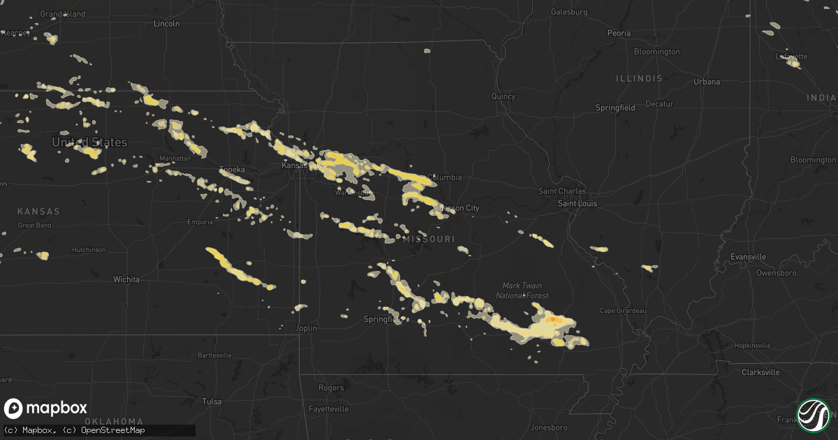
Hail Map in South Dakota on August 7, 2011
Get this storm
August 7 map
$229
one time, instant access
Download today. No call, no setup
Keep the $229
Bought the map and want the full workflow? Apply the entire $229 to a subscription within 7 days. None of it is wasted.
Every map, not just this one
This buys you this map. Subscription and you get every map we run, in the markets you choose from a few cities to whole states to nationwide. Plus real-time alerts the moment a storm fires.
Contact data
Name, contact info, occupancy, even credit band for addresses in the footprint. You go from where it hit to who to call.
Become the source they trust
Unlimited branding weather history reports on demand. You already have the documented answer ready for the property owner, and you are the one who showed up with it.
Property data and RoofTrace estimates
Pull up any address you have got, its value and the exact code rules for that jurisdiction, straight from One Click Code. Then RoofTrace estimates the squares, pitch, and roof value, priced the way you price.
Storm reports in South Dakota
South Dakota
| Date | Description |
|---|---|
| 08/07/20116:45 PM CDT | A local report indicates 60 MPH wind near 7 E REDIG |
| 08/07/20116:45 PM CDT | A local report indicates 60 MPH wind near 11 NE REDIG |
| 08/07/20116:40 PM CDT | Pea sized hail as well |
| 08/07/20116:30 PM CDT | A local report indicates 62 MPH wind near 5 NE PORCUPINE |
| 08/07/20116:30 PM CDT | A local report indicates 67 MPH wind near 8 SW BATESLAND |
| 08/07/20116:15 PM CDT | 3/4 inch hail too. |
| 08/07/20116:15 PM CDT | Small branches broken by wind gust. Pea size hail. |
| 08/07/20116:15 PM CDT | 1.30 inches of rain. Drifts of hail. Corn and garden plants stripped. |
| 08/07/20115:40 PM CDT | A local report indicates 1.00 inch wind near 2 SW KIRLEY |
| 08/07/20115:35 PM CDT | Nickel and quarter size hail |
| 08/07/20115:30 PM CDT | Pea to half dollar size hail. |
| 08/07/20115:30 PM CDT | A local report indicates 1.75 inch wind near 4 S RED SHIRT |
| 08/07/20115:22 PM CDT | A local report indicates 2.50 inch wind near DOWNTOWN BELLE FOURCHE |
| 08/07/20115:20 PM CDT | A local report indicates 1.00 inch wind near 10 S FOLSOM |
| 08/07/20115:20 PM CDT | A local report indicates 2.00 inch wind near 2 ESE BELLE FOURCHE RES |
| 08/07/20115:15 PM CDT | A local report indicates 1.25 inch wind near DOWNTOWN BELLE FOURCHE |
| 08/07/20115:00 PM CDT | A local report indicates 1.00 inch wind near 22 NE PHILIP |
| 08/07/20114:30 PM CDT | A local report indicates 1.50 inch wind near 3 SW HERMOSA |
| 08/07/20114:30 PM CDT | A local report indicates 1.75 inch wind near HERMOSA |
| 08/07/20114:10 PM CDT | A local report indicates 1.50 inch wind near 5 WNW HERMOSA |
| 08/07/20113:30 PM CDT | A local report indicates 2.75 inch wind near 4 E ROCKERVILLE |
| 08/07/20113:30 PM CDT | A local report indicates 1.75 inch wind near 7 SW DOWNTOWN RAPID CIT |
| 08/07/20113:23 PM CDT | A local report indicates 1.25 inch wind near 18 SW RAPID CITY AIRPOR |
| 08/07/20113:23 PM CDT | A local report indicates 1.25 inch wind near 6 SW DOWNTOWN RAPID CIT |
| 08/07/20113:23 PM CDT | Severe hail from 223 pm to 235 pm. |
| 08/07/20113:22 PM CDT | A local report indicates 1.00 inch wind near 3 SSE DOWNTOWN RAPID CI |
| 08/07/20113:22 PM CDT | A local report indicates 1.00 inch wind near 7 SW DOWNTOWN RAPID CIT |
| 08/07/20113:15 PM CDT | A local report indicates 1.75 inch wind near 4 SW DOWNTOWN RAPID CIT |
| 08/07/20113:15 PM CDT | A local report indicates 1.50 inch wind near 4 S DOWNTOWN RAPID CITY |
| 08/07/20113:13 PM CDT | A local report indicates 1.75 inch wind near 3 SW DOWNTOWN RAPID CIT |
| 08/07/20113:02 PM CDT | A local report indicates 1.00 inch wind near 4 SW DOWNTOWN RAPID CIT |
| 08/07/20113:00 PM CDT | A local report indicates 1.50 inch wind near 4 W DOWNTOWN RAPID CITY |
| 08/07/20112:15 PM CDT | Hailed from 115 pm to 135 pm. Hail covered the ground. |
| 08/07/20111:45 PM CDT | A local report indicates 1.75 inch wind near NEMO |
| 08/06/201111:34 PM CDT | A local report indicates 60 MPH wind near NORTH SIOUX CITY |
| 08/06/201110:01 PM CDT | At least 60 mph. Rocking farm equipment parked in yard |
| 08/06/20119:25 PM CDT | Also reported nickle size hail with the storm |
| 08/06/20118:30 PM CDT | A local report indicates 60 MPH wind near 6 N USTA |
| 08/06/20118:25 PM CDT | Also reported nickle size hail with the storm |
| 08/06/20118:05 PM CDT | 6-10 inch diameter tree branches broken off |
| 08/06/20118:05 PM CDT | A local report indicates 60 MPH wind near 8 WNW USTA |
| 08/06/20117:15 PM CDT | A local report indicates 60 MPH wind near 9 NW NISLAND |
| 08/06/20117:05 PM CDT | Pea to marble size hail |
| 08/06/20117:05 PM CDT | Pea to marble size hail |
| 08/06/20117:00 PM CDT | A local report indicates 60 MPH wind near 21 S PARMELEE |
| 08/06/20117:00 PM CDT | A local report indicates 1.75 inch wind near 21 S PARMELEE |
| 08/06/20117:00 PM CDT | A local report indicates 1.00 inch wind near 11 NNW BELLE FOURCHE RE |
All States Impacted by Hail Map on August 7, 2011
Cities Impacted by Hail Map on August 7, 2011
- Pittsburg, MO
- Ottawa, KS
- Pierceville, KS
- Garden City, KS
- Dighton, KS
- Clarksburg, MO
- Russellville, MO
- North Platte, NE
- Tipton, MO
- Bunceton, MO
- Florence, MO
- Syracuse, MO
- Otterville, MO
- California, MO
- Belle Fourche, SD
- Bucyrus, MO
- Licking, MO
- Asbury, MO
- Pittsburg, KS
- Opolis, KS
- Draper, SD
- Murdo, SD
- Hope, AR
- Holton, KS
- Lafayette, IN
- Wallace, NE
- Pine Ridge, SD
- Spearfish, SD
- Mankato, KS
- Esbon, KS
- Burr Oak, KS
- Cummings, KS
- Atchison, KS
- Ivan, AR
- Alamo, TN
- Humboldt, TN
- Alma, MO
- Blackburn, MO
- Evansville, IL
- Sparta, IL
- Walsh, IL
- Ellis Grove, IL
- Warren, AR
- Midland, SD
- Buffalo, SD
- Mansfield, MO
- Oneill, NE
- Kinsley, KS
- Hubbell, NE
- Chester, NE
- Merriman, NE
- Gordon, NE
- Concordia, MO
- Chesnee, SC
- Boiling Springs, SC
- Redford, MO
- Ellington, MO
- Saint Onge, SD
- Sweet Springs, MO
- Jamestown, KS
- Urich, MO
- Shepherd, MT
- Long Pine, NE
- Ainsworth, NE
- La Cygne, KS
- Walnut, KS
- Independence, MO
- Kearney, MO
- Liberty, MO
- Lyndon, KS
- Lancaster, KS
- Everest, KS
- Easton, KS
- Effingham, KS
- Eugene, MO
- Wellington, MO
- Franklin, MO
- Lone Jack, MO
- Odessa, MO
- Corder, MO
- Prairie Home, MO
- Holden, MO
- Higginsville, MO
- Levasy, MO
- Oak Grove, MO
- Waverly, MO
- Wooldridge, MO
- Marshall, MO
- Buckner, MO
- Blackwater, MO
- Jamestown, MO
- Jefferson City, MO
- Centertown, MO
- Grain Valley, MO
- Bates City, MO
- Boonville, MO
- Blue Springs, MO
- Dover, MO
- Sibley, MO
- Mayview, MO
- Henrietta, MO
- Excelsior Springs, MO
- Camden, MO
- Pilot Grove, MO
- Orrick, MO
- Napoleon, MO
- Warrensburg, MO
- Hardin, MO
- Lohman, MO
- Kansas City, MO
- Malta Bend, MO
- Nelson, MO
- Richmond, MO
- Lexington, MO
- Westmoreland, KS
- Frankfort, KS
- Olsburg, KS
- Blue Rapids, KS
- Larned, KS
- De Queen, AR
- Winnetoon, NE
- Medaryville, IN
- North Judson, IN
- Winamac, IN
- San Pierre, IN
- Prescott, AR
- Black Hawk, SD
- Merna, NE
- Broken Bow, NE
- Springfield, MO
- Somerset, OH
- Thornville, OH
- Rushville, OH
- Ulysses, KS
- Stover, MO
- Gravois Mills, MO
- Versailles, MO
- Cozad, NE
- Elwood, NE
- Eustis, NE
- Mill Spring, MO
- Russellville, AL
- Eldon, MO
- Clinton, MO
- Naper, NE
- Fort Pierre, SD
- Capitol, MT
- Alzada, MT
- Harvey, ND
- Oakley, KS
- Belvue, KS
- Wamego, KS
- Tioga, ND
- Healy, KS
- Miller, MO
- Drake, ND
- Anamoose, ND
- Hershey, NE
- Sutherland, NE
- Maxwell, NE
- Windsor, MO
- Beloit, KS
- Glenwood, MO
- Queen City, MO
- Quincy, OH
- Urbana, OH
- West Liberty, OH
- De Graff, OH
- Rosewood, OH
- Saint Paris, OH
- Muscotah, KS
- Whiting, KS
- Hammond, MT
- Caledonia, IL
- Capron, IL
- Poplar Grove, IL
- Belvidere, IL
- Jetmore, KS
- Plainview, NE
- Creighton, NE
- Leighton, AL
- Atkinson, NE
- Spencer, NE
- Butte, NE
- Seymour, MO
- Cherokee, AL
- Hunter, KS
- Edwards, MO
- Nemo, SD
- Bassett, NE
- Martin, ND
- Rugby, ND
- Brewster, NE
- Rapid City, SD
- Clyde, NY
- Johnstown, NE
- Yates Center, KS
- Madison, KS
- Gridley, KS
- Harveyville, KS
- Eskridge, KS
- Lenora, KS
- Logan, KS
- Bogue, KS
- Wanblee, SD
- Circleville, KS
- Lonedell, MO
- Saint Francis, SD
- Kilgore, NE
- Ekalaka, MT
- Baker, MT
- Grannis, AR
- Gillham, AR
- Botkins, OH
- Crookston, NE
- Gaylord, KS
- Cedar, KS
- Fairfield, NE
- Edgar, NE
- Rocklake, ND
- Bisbee, ND
- Kennebec, SD
- Poplar Bluff, MO
- Ellsinore, MO
- Williamsville, MO
- Voltaire, ND
- Hartshorne, OK
- Highwood, IL
- Highland Park, IL
- Hanston, KS
- Melbourne, AR
- Fletcher, MO
- Tuscumbia, AL
- Louisburg, MO
- Buffalo, MO
- Callaway, NE
- Ewing, NE
- Orchard, NE
- Page, NE
- Elsmere, NE
- Tishomingo, MS
- Rienzi, MS
- Booneville, MS
- Royal, NE
- Verdigre, NE
- Washington, KS
- McCrory, AR
- Arivaca, AZ
- Tucson, AZ
- Altamont, TN
- Spartanburg, SC
- Pacolet, SC
- Dumas, AR
- Iron City, TN
- Florence, AL
- Dallas, SD
- Gregory, SD
- Fordland, MO
- Rogersville, MO
- Montrose, MO
- Topeka, KS
- Lawrence, KS
- Berryton, KS
- Overbrook, KS
- Hardin, MT
- Willard, MO
- Fort Riley, KS
- Riley, KS
- Manhattan, KS
- Ogden, KS
- Junction City, KS
- Milford, KS
- Dumas, MS
- Ripley, MS
- Baldwyn, MS
- Pierce, NE
- Raymondville, MO
- Liberty Center, IN
- Iola, KS
- Gove, KS
- Belleville, KS
- Webber, KS
- Scandia, KS
- Courtland, KS
- Gadsden, TN
- Emerson, NE
- Winnebago, NE
- Griswold, IA
- Lewis, IA
- Oden, AR
- Norman, AR
- Mount Ida, AR
- Plano, IA
- Mystic, IA
- Richwoods, MO
- Blackwell, MO
- Dittmer, MO
- De Soto, MO
- Minot, ND
- Dennis, MS
- Searcy, AR
- Osawatomie, KS
- Paola, KS
- Minneapolis, KS
- Tescott, KS
- Stockton, KS
- Goldsboro, NC
- La Grange, NC
- Corning, KS
- Centralia, KS
- Jasper, GA
- Grady, AR
- Cumming, GA
- Dawsonville, GA
- Thedford, NE
- Chanute, KS
- Ballantine, MT
- Riverside, MO
- Honobia, OK
- Tremont, MS
- Wheatfield, IN
- Pleasantville, OH
- Wabash, IN
- Hermosa, SD
- Elkland, MO
- Nisland, SD
- Brunswick, NE
- Conway, MO
- Lonoke, AR
- Jacksonville, AR
- Cabot, AR
- Porcupine, SD
- Wounded Knee, SD
- Niangua, MO
- Marshfield, MO
- Success, MO
- Plato, MO
- Russell, AR
- Bald Knob, AR
- Bradford, AR
- Milesville, SD
- Tate, GA
- Talking Rock, GA
- Marble Hill, GA
- Ball Ground, GA
- Ellijay, GA
- Belvidere, SD
- Jewell, KS
- Sullivan, MO
- Cadet, MO
- Burlingame, KS
- Dupree, SD
- Kensington, KS
- Bristow, NE
- Lynch, NE
- Paxton, NE
- Laurel Hill, FL
- Onaga, KS
- Phil Campbell, AL
- Fort Leavenworth, KS
- Tuthill, SD
- Interior, SD
- Martin, SD
- Mount Hope, AL
- Batesville, IN
- Greensburg, IN
- Barboursville, VA
- Gordonsville, VA
- Oil Trough, AR
- Thida, AR
- Tellico Plains, TN
- Glasco, KS
- Delphos, KS
- Manderson, SD
- Smith Center, KS
- Epping, ND
- Wellfleet, NE
- Maywood, NE
- Bonnerdale, AR
- Kenesaw, NE
- Dalton, NE
- Fairburn, SD
- Keystone, SD
- Kyle, SD
- Essex, IA
- Clarinda, IA
- Superior, NE
- Hartville, MO
- Calhoun, MO
- Rolla, ND
- Perth, ND
- Red Cloud, NE
- Lucas, IA
- Woodburn, IA
- Stuttgart, AR
- McCune, KS
- Lawrenceville, GA
- Paradise, KS
- Natoma, KS
- Osborne, KS
- Alton, KS
- Waldo, KS
- Garden Prairie, IL
- Van Buren, MO
- Hill City, KS
- Scott, AR
- Little Rock, AR
- Gothenburg, NE
- Alma, KS
- Lewis, KS
- Lebo, KS
- Muscle Shoals, AL
- Marathon, TX
- Randall, KS
- Snow Hill, NC
- Greenleaf, KS
- Barnes, KS
- Waterville, KS
- Randolph, KS
- Morrowville, KS
- Valentine, NE
- Elsie, NE
- Long Lane, MO
- St John, KS
- Stafford, KS
- West Lafayette, IN
- Long Valley, SD
- White River, SD
- Town Creek, AL
- Courtland, AL
- Hillsboro, AL
- Wood River, NE
- Alda, NE
- Humboldt, KS
- West Jefferson, OH
- London, OH
- Webster, ND
- Muncie, IN
- Gaston, IN
- Fairmount, IN
- Cole Camp, MO
- Mineral Springs, AR
- Newport, AR
- Niobrara, NE
- Center, NE
- Lynchburg, MO
- Mountain Grove, MO
- Falcon, MO
- Lebanon, MO
- Benton, AR
- Scott City, KS
- Half Way, MO
- Hermitage, MO
- Urbana, MO
- Centerville, MO
- Ogallala, NE
- Brule, NE
- Loving, NM
- Maddock, ND
- Fessenden, ND
- Preston, MO
- Vermillion, KS
- Westpoint, IN
- Grinnell, KS
- New Haven, MO
- Gerald, MO
- Holcomb, KS
- Bottineau, ND
- New Underwood, SD
- Caputa, SD
- Hereford, AZ
- Colome, SD
- Winner, SD
- Shelton, NE
- Gibbon, NE
- La Monte, MO
- Green Ridge, MO
- Knob Noster, MO
- Houston, MO
- Ray, ND
- Weston, MO
- Glenwood, AR
- Caddo Gap, AR
- Umpire, AR
- Hornsby, TN
- Middleton, TN
- Free Union, VA
- Dyke, VA
- Granville, ND
- Towner, ND
- Springview, NE
- Puxico, MO
- Lane, KS
- Princeton, KS
- Richmond, KS
- Republic, KS
- Savannah, NY
- Lexington, NE
- Reading, KS
- Wakarusa, KS
- Munden, KS
- New Madison, OH
- West Manchester, OH
- Kirwin, KS
- Russell, IA
- Chariton, IA
- Belcourt, ND
- Kokomo, IN
- Greentown, IN
- Lawrenceburg, KY
- Smithville, MO
- Edgerton, MO
- Atwood, KS
- Quinter, KS
- Pittsburg, OK
- Rantoul, KS
- Wellsville, KS
- Offerle, KS
- Piedmont, MO
- Patterson, MO
- Greenville, MO
- Silva, MO
- Centerview, MO
- Hanover, KS
- Hollenberg, KS
- Mentone, TX
- Brady, NE
- Inavale, NE
- Guide Rock, NE
- Riverton, NE
- Juniata, NE
- Amelia, NE
- Valley Falls, KS
- Rocheport, MO
- Sublette, KS
- Marienthal, KS
- Platte City, MO
- Waldron, MO
- Deepwater, MO
- Warsaw, MO
- Kadoka, SD
- De Soto, IL
- Hurst, IL
- Carterville, IL
- Auburn, GA
- Longford, KS
- Linn, MO
- Grovespring, MO
- Phillipsburg, MO
- Columbus, KS
- Endicott, NE
- Fairbury, NE
- Eaton, IN
- Matthews, IN
- Upland, IN
- Herrin, IL
- West Frankfort, IL
- Freeman Spur, IL
- Wood Lake, NE
- Abilene, KS
- Purdum, NE
- Parmelee, SD
- Climax Springs, MO
- Smithville, MS
- Virgil, KS
- Benedict, KS
- Erie, KS
- Osmond, NE
- Charlottesville, VA
- Ruckersville, VA
- England, AR
- Prim, AR
- Drasco, AR
- Mountain View, AR
- Allen, SD
- Batesland, SD
- Glen Elder, KS
- Bennington, KS
- Wappapello, MO
- McGee, MO
- Keo, AR
- Winona, MO
- Birch Tree, MO
- Eminence, MO
- Clubb, MO
- Lowndes, MO
- Lodi, MO
- Vulcan, MO
- Fremont, MO
- Sandusky, MI
- Wakefield, KS
- Alta Vista, KS
- Fair Grove, MO
- Creighton, MO
- Garden City, MO
- Butler, MO
- Archie, MO
- Kansas City, KS
- Delight, AR
- Union, SC
- Lansing, KS
- Leavenworth, KS
- Kearney, NE
- Bryant, AR
- West Point, MS
- Spruce Pine, AL
- Saint Mary, MO
- Home, KS
- Marysville, KS
- Meadow, SD
- Whitewood, SD
- Lebanon, KS
- Saint Joseph, MI
- Wildwood, GA
- Hartshorn, MO
- Salem, MO
- Animas, NM
- Karlsruhe, ND
- Madrid, NE
- Norfolk, NE
- Hoskins, NE
- Williston, ND
- Meadow Grove, NE
- Tilden, NE
- Neligh, NE
- Strafford, MO
- Balfour, ND
- De Witt, AR
- Dodge City, KS
- Chocowinity, NC
- Alexander, AR
- Detroit, AL
- Calico Rock, AR
- Chapman, KS
- Conover, OH
- Mclean, NE
- Randolph, NE
- Fontana, KS
- Fulton, MS
- Golden, MS
- Loup City, NE
- Ashton, NE
- Emmet, NE
- Norton, KS
- Labelle, FL
- Cuba, KS
- Meade, KS
- Fredonia, KS
- Mechanicsburg, OH
- Galloway, OH
- Berrien Springs, MI
- Stevensville, MI
- Benton Harbor, MI
- Belden, NE
- Laurel, NE
- Stuart, NE
- Jal, NM
- Ulster, PA
- Milan, PA
- Goff, KS
- Greenville, NC
- Ayden, NC
- Grimesland, NC
- Roscoe, IL
- Brownsville, TN
- Star City, AR
- Pomona, KS
- Williamsburg, KS
- Hamburg, AR
- Humansville, MO
- Fountain Hill, AR
- Grandin, MO
- Manchester, TN
- Amoret, MO
- Foster, MO
- Lodgepole, NE
- Scranton, KS
- Fortuna, MO
- Sulligent, AL
- Dierks, AR
- Souris, ND
- Baldwin City, KS
- Winchester, KS
- Nortonville, KS
- Willow City, ND
- Denver, IN
- Urbana, IN
- Hugoton, KS
- Reva, SD
- Overton, NE
- Monticello, AR
- Quenemo, KS
- Vassar, KS
- Burwell, NE
- Netawaka, KS
- Columbus, OH
- Lincoln, MO
- Vienna, MO
- Dixon, MO
- Bolivar, TN
- Hickory Valley, TN
- Bonesteel, SD
- Inman, NE
- Raeford, NC
- Amity, AR
- Marietta, MS
- New Albany, MS
- New Site, MS
- Blue Mountain, MS
- Oronogo, MO
- Wheatland, MO
- Metamora, IN
- Laurel, IN
- Glen, MS
- Mills, NE
- Pleasanton, KS
- Brookville, OH
- Newcastle, WY
- Remington, IN
- Wolcott, IN
- Lake Ozark, MO
- Sunrise Beach, MO
- Bremen, KS
- Emmet, AR
- Newton, IA
- Lake Villa, IL
- Antioch, IL
- Mountain View, MO
- Park, KS
- South Greenfield, MO
- Iuka, MS
- Deadwood, SD
- Bronaugh, MO
- Liberal, MO
- Mabelvale, AR
- Eddyville, NE
- Presho, SD
- Athol, KS
- Winona, KS
- Lead, SD
- Allen, KS
- Bertrand, NE
- Cabool, MO
- Windsor, NY
- Altheimer, AR
- Grant, NE
- Batesville, AR
- Blackfoot, ID
- Bridgeview, IL
- Willowbrook, IL
- Willow Springs, IL
- Palos Park, IL
- Worth, IL
- Palos Hills, IL
- Hickory Hills, IL
- Willow Springs, MO
- Humphrey, AR
- Walnut, MS
- Melrose, IA
- Moulton, AL
- Osage City, KS
- Newport, NE
- Saint Marys, KS
- Emmett, KS
- Dickens, NE
- Florala, AL
- Weaubleau, MO
- Doniphan, MO
- Hensley, AR
- Formoso, KS
- Rison, AR
- Farley, MO
- Rocky Mount, MO
- Clayton, KS
- Jennings, KS
- Steele City, NE
- Worden, MT
- Huntley, MT
- Flemington, MO
- Bolivar, MO
- Horton, KS
- Concordia, KS
- Grenada, MS
- Sidney, OH
- Bellefontaine, OH
- Trinity, AL
- Chicago, IL
- Summit Argo, IL
- Rolla, KS
- Glade, KS
- Mission, SD
- Rosebud, MO
- Missouri City, MO
- Towanda, PA
- Polk, MO
- Miami, FL
- Greenwood Springs, MS
- Amory, MS
- South Pittsburg, TN
- Corinth, MS
- Burnsville, MS
- Homestead, FL
- Piedmont, SD
- Phillipsburg, KS
- McCaysville, GA
- Epworth, GA
- Arnett, OK
- Grand Island, NE
- Demotte, IN
- Fair Oaks, IN
- Wauconda, IL
- Hot Springs, SD
- Wakefield, NE
- Jacob, IL
- Keystone, NE
- Modoc, IL
- Prairie Du Rocher, IL
- Brighton, MO
- Barnard, KS
- Sylvan Grove, KS
- Camden Point, MO
- Clarkesville, GA
- Mount Airy, GA
- Pinehurst, NC
- Aberdeen, NC
- Southern Pines, NC
- Eagle Butte, SD
- Jonesville, SC
- Autryville, NC
- Campobello, SC
- Vernon Hills, IL
- Mundelein, IL
- Libertyville, IL
- Lincolnshire, IL
- Deerfield, IL
- Lake Forest, IL
- Buffalo Grove, IL
- Gurnee, IL
- Waukegan, IL
- Gaffney, SC
- Marlette, MI
- Snover, MI
- Hastings, NE
- Hamilton, MS
- Dunnegan, MO
- Mchenry, IL
- Bells, TN
- Promise City, IA
- Elm Creek, NE
- Hillsboro, TN
- Estill Springs, TN
- Dresden, KS
- Killen, AL
- Rogersville, AL
- Salvisa, KY
- Harrodsburg, KY
- Anna, OH
- Maplewood, OH
- Mercer, TN
- Homer, NE
- Allen, NE
- Thurston, NE
- Hubbard, NE
- Odessa, NE
- Bloomfield, MO
- Elk Creek, MO
- Huggins, MO
- Eunice, MO
- Dudley, MO
- Yukon, MO
- Des Arc, MO
- Solo, MO
- Summersville, MO
- Roby, MO
- Aberdeen, MS
- Hardy, NE
- Brookville, IN
- Hookerton, NC
- Pine Bluff, AR
- Donovan, IL
- Defuniak Springs, FL
- Aurora, NC
- Soldier, KS
- Marion, IN
- Hartford City, IN
- Montpelier, IN
- Rolla, MO
- Newburg, MO
- Kewanna, IN
- Rochester, IN
- Macy, IN
- Alton, MO
- Lockbourne, OH
- Groveport, OH
- Grove City, OH
- Rensselaer, IN
- Wadsworth, IL
- Mena, AR
- Markle, IN
- Warren, IN
- Huntington, IN
- Coffeeville, MS
- Tillatoba, MS
- Selmer, TN
- Tullahoma, TN
- Albion, NE
- Petersburg, NE
- Scotia, NE
- Spencer, TN
- Gould, AR
- Mingo, IA
- Burke, SD
- Donalsonville, GA
- Sparkman, AR
- Waverly, KS
- Lemmon, SD
- Lexington, AL
- Carnesville, GA
- Toccoa, GA
- Kismet, KS
- Roberts, ID
- Bingham, NE
- Stanton, TN
- Friendship, TN
- Leslie, MO
- Fowler, IN
- Goodland, IN
- Clarks Hill, IN
- Egeland, ND
- Parsons, KS
- Smithville, OK
- Sherrill, AR
- Deering, ND
- Trevor, WI
- Eastanollee, GA
- Martin, GA
- Sneads, FL
- Wausa, NE
- Bloomfield, NE
- Sparta, TN
- Lyons, NY
- Guntown, MS
- Oberlin, KS
- Herndon, KS
- Wapakoneta, OH
- Jackson Center, OH
- Weir, KS
- Jackson Springs, NC
- Nelson, NE
- Poneto, IN
- Linn, KS
- Mantachie, MS
- Vanceboro, NC
- Eagletown, OK
- Wagner, SD
- Mason City, NE
- Vivian, SD
- Carbondale, KS
- Melvern, KS
- Vale, SD
- Fox Lake, IL
- Spring Grove, IL
- Bethel Springs, TN
- Esmond, ND
- Ava, MO
- Jakin, GA
- Troy, NC
- Asheboro, NC
- Chambers, NE


