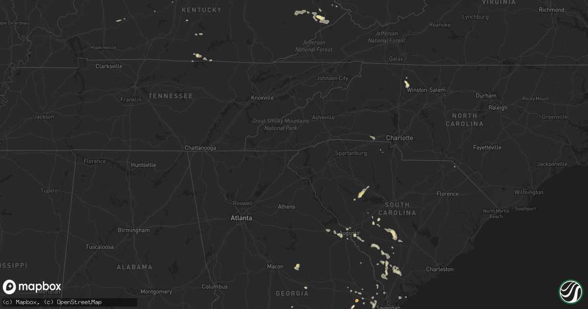
Hail Map in Indiana on August 13, 2011
Get this storm
August 13 map
$229
one time, instant access
Download today. No call, no setup
Keep the $229
Bought the map and want the full workflow? Apply the entire $229 to a subscription within 7 days. None of it is wasted.
Every map, not just this one
This buys you this map. Subscription and you get every map we run, in the markets you choose from a few cities to whole states to nationwide. Plus real-time alerts the moment a storm fires.
Contact data
Name, contact info, occupancy, even credit band for addresses in the footprint. You go from where it hit to who to call.
Become the source they trust
Unlimited branding weather history reports on demand. You already have the documented answer ready for the property owner, and you are the one who showed up with it.
Property data and RoofTrace estimates
Pull up any address you have got, its value and the exact code rules for that jurisdiction, straight from One Click Code. Then RoofTrace estimates the squares, pitch, and roof value, priced the way you price.
Storm reports in Indiana
Indiana
| Date | Description |
|---|---|
| 08/13/20116:49 PM CDT | Multiple trees down. Tree down on powerlines on west side of logansport. |
| 08/13/20116:39 PM CDT | Multiple trees down. Time estimated by radar |
| 08/13/20116:37 PM CDT | A local report indicates 1.75 inch wind near DAYTON |
| 08/13/20116:31 PM CDT | Several trees down. Pea sized hail. Estimated winds of 60 mph. |
| 08/13/20116:30 PM CDT | Multiple trees down 3-4 inches in diameter |
| 08/13/20116:30 PM CDT | A local report indicates 1.00 inch wind near 1 S LAFAYETTE |
| 08/13/20116:29 PM CDT | A local report indicates 59 MPH wind near LAFAYETTE |
| 08/13/20116:28 PM CDT | Trees down...no size available |
| 08/13/20116:25 PM CDT | A local report indicates 60 MPH wind near 4 WSW CLARKS HILL |
| 08/13/20116:14 PM CDT | A local report indicates 1.00 inch wind near 8 NW LAFAYETTE |
| 08/13/20116:12 PM CDT | A local report indicates 1.00 inch wind near 8 NW LAFAYETTE |
| 08/13/20115:45 PM CDT | Two inch diameter hail was reported near 500s and 500w. |
| 08/13/20115:30 PM CDT | Public reported hail from quarter sized to almost golf ball size. |
| 08/13/20115:15 PM CDT | Delayed report. Hail size varied from 0.25 to 1.25 inches |
| 08/13/20114:55 PM CDT | Delayed report. Cracked windshield. Traffic on i-65 was forced to stop due to the size of the hail. Size estimated from 1.00 to 1.50. |
| 08/13/20114:53 PM CDT | Measured by awos at clark county airport |
| 08/13/20114:53 PM CDT | Measured by awos at clark county airport |
| 08/13/20114:50 PM CDT | I-65 and in-2 |
| 08/13/20114:50 PM CDT | Front of apartment building along green tree bvld blown over. |
| 08/13/20114:43 PM CDT | Small to medium sized tree limbs down near the intersection of st. Marys and banet rds. |
| 08/13/20114:41 PM CDT | Thunderstorm winds downed several trees in new albany. Power lines fell across north tucker and old hill roads. |
| 08/13/20114:37 PM CDT | Several trees were downed in georgetown. Fallen power lines briefly closed kepley and cooks mill roads. |
| 08/13/20114:35 PM CDT | 2 reports received of estimated wind gusts of 60 mph in the lanesville area |
| 08/13/20114:21 PM CDT | Report relayed of trees down in the corydon area |
| 08/13/20114:12 PM CDT | Dispatch reports power lines down along speed rd. |
| 08/13/20114:06 PM CDT | Report of tree down outside of leavenworth |
| 08/13/20113:58 PM CDT | At least one tree reported down near the intersection of indiana state highway 64 and patoka school rd. |
| 08/13/20113:44 PM CDT | At least one tree reported down near the intersection of indiana state highway 64 and patoka school rd. |
| 08/13/20113:40 PM CDT | Dispatch reports trees down along indiana state highway 64 near the intersection of hardscrabble rd. |
| 08/13/20113:10 PM CDT | Public report of hail ranging from dime to quarter sized. Time estimated from radar. |
| 08/12/201110:12 PM CDT | A local report indicates 1.00 inch wind near 3 SW BLOOMINGTON |
| 08/12/201110:05 PM CDT | Pea sized hail accompanied the wind. |
| 08/12/20119:58 PM CDT | Located near state road 48 and harstrait |
| 08/12/20119:10 PM CDT | Trees blocking roadways |
| 08/12/20118:45 PM CDT | 4-inch diameter tree limb down...accompanied by 50 mph winds |
| 08/12/20118:38 PM CDT | Several trees and power lines down...mainly across the southern portions of the county. |
| 08/12/20118:25 PM CDT | Small branches down and power flashes in the distance...a brief whirl wind of some sort |
| 08/12/20118:19 PM CDT | A local report indicates 1.00 inch wind near 1 N BERNE |
| 08/12/20118:13 PM CDT | A local report indicates 1.50 inch wind near 1 N PENDLETON |
| 08/12/20118:08 PM CDT | A local report indicates 60 MPH wind near FORTVILLE |
| 08/12/20118:03 PM CDT | Nickel to quarter size hail currently falling |
| 08/12/20117:58 PM CDT | Relayed report of 60 mph or greater wind. |
| 08/12/20117:58 PM CDT | Several trees and power lines down in hartford city and throughout the county. Time estimated from radar. |
| 08/12/20117:50 PM CDT | *** 4 fatal *** stage collapse during concert...multiple injuries...coroner on scene...winds estimated between 60 and 70 mph. |
| 08/12/20117:50 PM CDT | Located at us 40 and center street |
| 08/12/20117:49 PM CDT | Reported by long-time television weather spotter. A large 100-year old tree was blown down. Power is out in neighborhood. |
| 08/12/20117:49 PM CDT | A large 100-year old tree was blown down and power knocked out from a measured 70 mph wind gust. Reported by long-time television weather spotter. |
| 08/12/20117:45 PM CDT | Multiple trees and tree limbs reported down in a small... Confined area |
| 08/12/20117:40 PM CDT | Numerous reports of trees down across the county. Large tree blocking road at route 18 and western avenue. |
| 08/12/20117:33 PM CDT | Also had pea to nickel size hail |
| 08/12/20117:24 PM CDT | Trees down...time estimated from radar |
| 08/12/20117:20 PM CDT | Car hit by falling tree...no injuries reported...time estimated from radar |
| 08/12/20117:10 PM CDT | Tree limbs down on power lines. Several other reports of trees and power lines down across the southern portion of miami county. Time estimated from radar. |
All States Impacted by Hail Map on August 13, 2011
Cities Impacted by Hail Map on August 13, 2011
- Knox, IN
- La Crosse, IN
- Hanna, IN
- Lafayette, IN
- Dayton, IN
- Rochester, IN
- Kewanna, IN
- Boonville, NC
- Yadkinville, NC
- Grant, CO
- Yermo, CA
- Clayhole, KY
- Jackson, KY
- Gunlock, KY
- Vest, KY
- Valparaiso, IN
- Spencer, IN
- Freedom, IN
- Genoa, IL
- Raton, NM
- Gilman, IL
- Ellery, IL
- Golden Gate, IL
- Palatine, IL
- Arlington Heights, IL
- Buffalo Grove, IL
- Lake Zurich, IL
- Walker, WV
- Augusta, GA
- Leesville, SC
- Wagener, SC
- Pelion, SC
- Inwood, WV
- Martinsburg, WV
- Hedgesville, WV
- Gerrardstown, WV
- Eckerty, IN
- Birdseye, IN
- Elizabeth, PA
- Mckeesport, PA
- Clairton, PA
- Canton, IL
- Glasford, IL
- Greencastle, IN
- Cloverdale, IN
- Onarga, IL
- Crescent City, IL
- Odell, IL
- Mount Pulaski, IL
- Lincoln, IL
- Elkhart, IL
- New Holland, IL
- Middletown, IL
- Hilton Head Island, SC
- Bluffton, SC
- Solsberry, IN
- Bloomington, IN
- Marathon, TX
- Mount Olive, IL
- Litchfield, IL
- Walshville, IL
- Lombard, IL
- Glen Ellyn, IL
- Hoopeston, IL
- Milford, IL
- Wellington, IL
- Jackson, SC
- Aiken, SC
- West Lafayette, IN
- Fort Stockton, TX
- Barrington, IL
- Beloit, WI
- Janesville, WI
- Orfordville, WI
- Lebanon Junction, KY
- Boston, KY
- Claxton, GA
- Fowler, IN
- Ambia, IN
- Oxford, IN
- Pine Village, IN
- Boswell, IN
- Templeton, IN
- Cynthiana, KY
- Berry, KY
- Rockford, IL
- Jeffersonville, IN
- Clarksville, IN
- Sellersburg, IN
- Onondaga, MI
- Parma, MI
- Rives Junction, MI
- Clifton, IL
- Ashkum, IL
- Woodridge, IL
- Virgie, KY
- Beaver, KY
- Teaberry, KY
- Robinson Creek, KY
- McDowell, KY
- Pikeville, KY
- Betsy Layne, KY
- Harold, KY
- Ocala, FL
- Waverly, IL
- Jacksonville, IL
- Franklin, IL
- Pontiac, IL
- Flanagan, IL
- Graymont, IL
- Mountain Top, PA
- Nescopeck, PA
- Berwick, PA
- Wapwallopen, PA
- Mifflinville, PA
- Drums, PA
- Bloomsburg, PA
- Sugarloaf, PA
- Buchanan, MI
- Niles, MI
- Galien, MI
- Sparta, MI
- Conklin, MI
- De Land, IL
- Clinton, IL
- Weldon, IL
- Early Branch, SC
- Yemassee, SC
- Pembroke, GA
- Portage, IN
- Merrillville, IN
- Gary, IN
- Hobart, IN
- Bloomington, IL
- Forreston, IL
- Polo, IL
- Lowell, IN
- Crown Point, IN
- Wilmington, IL
- Elwood, IL
- Manhattan, IL
- Anderson, IN
- Middletown, IN
- Markleville, IN
- Pendleton, IN
- Model, CO
- Leland, IL
- Berne, IN
- Bluffton, IN
- Geneva, IN
- Monroe, IN
- Trinidad, CO
- Weston, CO
- Deputy, IN
- Madison, IN
- Chebanse, IL
- Herscher, IL
- Buckingham, IL
- Cabery, IL
- Burkesville, KY
- Cullom, IL
- Lawton, MI
- Mcconnelsville, OH
- Cumberland, OH
- Blue Rock, OH
- Kimbolton, OH
- Newcomerstown, OH
- Waverly, WV
- Rincon, GA
- Hidalgo, IL
- Newton, IL
- Latham, IL
- Warrensburg, IL
- Metamora, IL
- Grovetown, GA
- Aurora, IL
- Naperville, IL
- Hartsburg, IL
- Atlanta, IL
- Emden, IL
- Centertown, KY
- Central City, KY
- Woodstock, IL
- Schnellville, IN
- Dubois, IN
- Saint Anthony, IN
- Jasper, IN
- Celestine, IN
- Ivesdale, IL
- Yorkville, IL
- Bolingbrook, IL
- Plainfield, IL
- Oswego, IL
- La Porte, IN
- Huntingburg, IN
- Loami, IL
- Winchester, IL
- Weirsdale, FL
- Lady Lake, FL
- Ocklawaha, FL
- Summerfield, FL
- Mumford, NY
- Caledonia, NY
- Scottsville, NY
- Oconto, NE
- Callaway, NE
- Byron Center, MI
- Hudsonville, MI
- Decatur, IN
- Lanark, IL
- San Jose, IL
- Mason City, IL
- Moweaqua, IL
- Bethany, IL
- Smithfield, KY
- Eminence, KY
- Paris Crossing, IN
- Lexington, IN
- Commiskey, IN
- Hanover, IN
- Cisco, IL
- Charlotte, MI
- Vermontville, MI
- Mulliken, MI
- Shannon, IL
- Ashland, IL
- Virginia, IL
- Arenzville, IL
- Grandfalls, TX
- Dryden, TX
- McLean, IL
- Mount Morris, IL
- Pearl City, IL
- Rochelle, IL
- Oregon, IL
- Chana, IL
- Mount Carroll, IL
- Easton, IL
- Kilbourne, IL
- Havana, IL
- Fruitland Park, FL
- Rossville, IN
- Dunkirk, IN
- Michigan City, IN
- Chesterton, IN
- Decker, IN
- Mount Carmel, IL
- Mapleton, IL
- Pekin, IL
- Peoria, IL
- Farmer City, IL
- Dwight, IL
- Grand Rapids, MI
- Grandville, MI
- Jenison, MI
- Alapaha, GA
- Nashville, GA
- Rockbridge, IL
- Monon, IN
- Winamac, IN
- Monticello, IN
- Buffalo, IN
- Star City, IN
- Francesville, IN
- Monticello, IL
- Sheridan, IL
- Sandwich, IL
- Newark, IL
- Shepherdsville, KY
- Ashton, IL
- Steward, IL
- Elfrida, AZ
- Marseilles, IL
- Wabash, IN
- Urbana, IN
- Otterbein, IN
- Isonville, KY
- Ellabell, GA
- Carbon, IN
- Rosedale, IN
- Ontario, NY
- Macedon, NY
- Walworth, NY
- Chesterfield, IL
- Carlinville, IL
- Waterman, IL
- Folkston, GA
- Shipman, IL
- Gillespie, IL
- Saint Meinrad, IN
- Saint Croix, IN
- Tell City, IN
- Bristow, IN
- Branchville, IN
- Ferdinand, IN
- New Castle, IN
- Chicago, IL
- Park Ridge, IL
- Harwood Heights, IL
- Schiller Park, IL
- Bensenville, IL
- Des Plaines, IL
- Minonk, IL
- Hebron, IN
- Vandalia, IL
- Pleasant Plains, IL
- Springfield, IL
- Sylvania, GA
- Scotts, MI
- Yale, IL
- Eddyville, NE
- Sumner, NE
- Columbia, KY
- Irwinton, GA
- Toomsboro, GA
- McIntyre, GA
- East Leroy, MI
- Vicksburg, MI
- Climax, MI
- Fulton, MI
- Petersburg, WV
- Durand, IL
- Fisherville, KY
- Louisville, KY
- Simpsonville, KY
- Lisle, IL
- Downers Grove, IL
- Washburn, IL
- Toluca, IL
- Farmington, MI
- Novi, MI
- Sierra Blanca, TX
- Broken Bow, NE
- Switz City, IN
- Linton, IN
- Rockford, MI
- Sugar Grove, IL
- Big Rock, IL
- Hawthorne, FL
- Fort McCoy, FL
- Citra, FL
- Interlachen, FL
- McNabb, IL
- Lostant, IL
- Leaf River, IL
- Jewett, IL
- Burlington, WI
- Genoa City, WI
- Newaygo, MI
- Grant, MI
- Uhrichsville, OH
- Battle Creek, MI
- Marshall, MI
- Ceresco, MI
- Burlington, MI
- Farmersville, IL
- Divernon, IL
- Virden, IL
- Algonquin, IL
- Fox River Grove, IL
- Palatka, FL
- Satsuma, FL
- Jefferson, CO
- Bailey, CO
- Le Roy, IL
- Mount Olivet, KY
- Silex, MO
- Lake Station, IN
- Schererville, IN
- Greenview, IL
- Athens, IL
- White Oak, GA
- Polk City, FL
- Gregory, MI
- Chelsea, MI
- Dexter, MI
- Summit Argo, IL
- La Grange, IL
- Clarendon Hills, IL
- Justice, IL
- Bridgeview, IL
- Hinsdale, IL
- Willowbrook, IL
- Western Springs, IL
- Westmont, IL
- Darien, IL
- Demotte, IN
- Shelby, IN
- Saluda, SC
- Silverstreet, SC
- Newberry, SC
- Walsenburg, CO
- Maroa, IL
- Rush, NY
- Brooklet, GA
- Tremont, IL
- Mackinaw, IL
- Roanoke, IN
- South Lyon, MI
- Whitmore Lake, MI
- Pinckney, MI
- Brighton, MI
- Hamburg, MI
- Dekalb, IL
- Malta, IL
- Paris, IL
- Redmon, IL
- Brocton, IL
- Rankin, IL
- Cissna Park, IL
- Armington, IL
- Hardy, KY
- Stone, KY
- Morris, IL
- Davis Junction, IL
- Corning, OH
- Crooksville, OH
- Minooka, IL
- Cary, IL
- Findlay, IL
- Sullivan, IL
- Windsor, IL
- Peotone, IL
- Putnam, IL
- Fremont, MI
- Georgetown, KY
- Stamping Ground, KY
- Ada, MI
- Lowell, MI
- Belmont, MI
- Casnovia, MI
- Woodbine, GA
- Waverly, GA
- Milledgeville, IL
- Brazil, IN
- Reelsville, IN
- Waynesville, IL
- Beason, IL
- Wapella, IL
- Kenney, IL
- Long Point, IL
- Cornell, IL
- Pecatonica, IL
- Rochester, NY
- Mulberry Grove, IL
- Saunemin, IL
- Springfield, GA
- Clyo, GA
- Hamlet, IN
- Albion, IL
- McColl, SC
- English, IN
- Grantsburg, IN
- Marengo, IN
- Taswell, IN
- North Augusta, SC
- Somonauk, IL
- Bardstown, KY
- Cordova, SC
- Cope, SC
- Orangeburg, SC
- Browns, IL
- Evansville, IN
- Owensville, IN
- Haubstadt, IN
- Grayville, IL
- Poseyville, IN
- Griffin, IN
- Wadesville, IN
- New Harmony, IN
- Cynthiana, IN
- Shortsville, NY
- Farmington, NY
- Canandaigua, NY
- Victor, NY
- Bloomfield, NY
- Beech Island, SC
- Salley, SC
- Colfax, IL
- Howard City, MI
- Lake In The Hills, IL
- Carpentersville, IL
- Register, GA
- Metter, GA
- Augusta, MO
- Defiance, MO
- Marthasville, MO
- Grant Park, IL
- South Haven, MI
- Covert, MI
- Ransom, IL
- Roanoke, IL
- Lowpoint, IL
- Jupiter, FL
- Loxahatchee, FL
- West Palm Beach, FL
- Groveland, IL
- Manito, IL
- Skokie, IL
- Evanston, IL
- Sheldon, IL
- Martinton, IL
- Emington, IL
- Watseka, IL
- Kempton, IL
- Webster, NY
- Doerun, GA
- Trinchera, CO
- Tampa, FL
- Jamestown, TN
- Georgetown, IN
- Floyds Knobs, IN
- Fort Lauderdale, FL
- Shabbona, IL
- Hinckley, IL
- Streator, IL
- Rutland, IL
- Dana, IL
- Cedar Lake, IN
- Three Rivers, MI
- Paris, KY
- Varnville, SC
- Estill, SC
- Pineland, SC
- Ulmer, SC
- Donnellson, IL
- Fairport, NY
- Chestnut, IL
- Hephzibah, GA
- Bloomingdale, GA
- Winfield, IL
- West Chicago, IL
- Rentz, GA
- Dublin, GA
- Frankfort, KY
- Elkton, FL
- Dowagiac, MI
- Delphi, IN
- Battle Ground, IN
- Burton, WV
- Holbrook, PA
- Spraggs, PA
- Wana, WV
- New Freeport, PA
- Portland, IN
- Hennepin, IL
- Pawnee, IL
- Spencerville, OH
- Venedocia, OH
- Rockford, OH
- Mendon, OH
- Immokalee, FL
- Fithian, IL
- Marion, NY
- Palmyra, NY
- West Henrietta, NY
- Lizton, IN
- Waterford, WI
- Celina, TN
- Seneca, IL
- Mendon, MI
- Alma, IL
- Salem, IL
- Brunson, SC
- Fairfax, SC
- Leslie, MI
- Westcliffe, CO
- Stanford, IL
- Mchenry, IL
- Cannelton, IN
- Derby, IN
- Union Star, KY
- Sigel, IL
- Norman Park, GA
- Comstock Park, MI
- Kent City, MI
- Twelve Mile, IN
- Lucerne, IN
- Fairfield, IL
- Cisne, IL
- Decatur, IL
- McArthur, OH
- Frankfort, IN
- Cutler, IN
- Barnwell, SC
- Harlem, GA
- Appling, GA
- Varna, IL
- Richmond, IL
- Hebron, IL
- Hesperia, MI
- Deltona, FL
- Lake Helen, FL
- Muncie, IN
- Winslow, IN
- Dansville, NY
- Eaton Rapids, MI
- Olivet, MI
- Albion, MI
- Springport, MI
- Coopersville, MI
- Cedar Springs, MI
- Marne, MI
- Leitchfield, KY
- Wauconda, IL
- Bloomfield, IN
- West Lafayette, OH
- Plainfield, OH
- Fresno, OH
- Port Washington, OH
- Coshocton, OH
- Marcellus, MI
- Jones, MI
- Eighty Four, PA
- Finleyville, PA
- Bentleyville, PA
- Plano, IL
- Crestwood, KY
- Wyoming, MI
- Kingsland, GA
- Royal Center, IN
- Daleville, IN
- East Troy, WI
- Elkhorn, WI
- The Villages, FL
- Wildwood, FL
- Neeses, SC
- Hoffman Estates, IL
- Elgin, IL
- Williamson, NY
- Penfield, NY
- Honeoye, NY
- Preston, MD
- Trappe, MD
- Ridott, IL
- Rome, IN
- Daggett, CA
- Olar, SC
- Ehrhardt, SC
- Alexandria, IN
- Frankton, IN
- Chrisman, IL
- Ridge Farm, IL
- Union Grove, WI
- Sturtevant, WI
- Kennard, IN
- Shirley, IN
- Owaneco, IL
- Taylorville, IL
- Gibson City, IL
- New Matamoras, OH
- Graysville, OH
- Brunswick, GA
- Townsend, GA
- Darien, GA
- Joliet, IL
- Channahon, IL
- Kingston Mines, IL
- Morton, IL
- Danvers, IL
- Georgetown, IL
- Indianola, IL
- Catlin, IL
- Stephensport, KY
- Hardinsburg, KY
- Lebanon, IN
- Summersville, KY
- York, SC
- Garnett, SC
- Hampton, SC
- Jeromesville, OH
- Springwater, NY
- New Concord, OH
- Jackson, MI
- Howell, MI
- Glendale Heights, IL
- Bloomingdale, IL
- Heltonville, IN
- Bedford, IN
- Kings Mountain, NC
- Fairbury, IL
- Forrest, IL
- Piper City, IL
- Chatsworth, IL
- Bunnell, FL
- East Palatka, FL
- Hastings, FL
- Edinburg, IL
- Rochester, IL
- Thomson, GA
- White Cloud, MI
- Manchester, MD
- Hampstead, MD
- Geff, IL
- Beardstown, IL
- Chatham, IL
- Clayton, IN
- Eastman, GA
- Rhine, GA
- Neoga, IL
- Mattoon, IL
- Deland, FL
- New Berlin, IL
- Albany, KY
- Kalamazoo, MI
- Paw Paw, MI
- Portage, MI
- Mattawan, MI
- Serena, IL
- Downs, IL
- Normal, IL
- Pleasureville, KY
- Montezuma, IN
- Hillsdale, IN
- West Finley, PA
- Malta, OH
- River Grove, IL
- Franklin Park, IL
- Maywood, IL
- Melrose Park, IL
- Elmwood Park, IL
- River Forest, IL
- Sterling, IL
- Woosung, IL
- Dixon, IL
- Franklin Grove, IL
- Itasca, IL
- Wood Dale, IL
- Mundelein, IL
- Island Lake, IL
- Grayslake, IL
- Plymouth, MI
- Branchville, SC
- North Judson, IN
- Grovertown, IN
- Wanatah, IN
- Allons, TN
- North Manchester, IN
- Lakeland, FL
- Auburndale, FL
- Grover, NC
- Shelby, NC
- Sarahsville, OH
- Summerfield, OH
- Senecaville, OH
- Quaker City, OH
- Grand Ledge, MI
- Sorrento, FL
- Bloomingdale, IN
- Clinton, IN
- Bryant, IN
- Springville, IN
- Owensburg, IN
- Cutler, IL
- Pittsford, NY
- Henrietta, NY
- Reddick, IL
- Kenosha, WI
- Edwardsburg, MI
- Cassopolis, MI
- Ypsilanti, MI
- Kouts, IN
- Pecos, TX
- Argenta, IL
- Vandalia, MI
- Apopka, FL
- Fitzgerald, GA
- Constantine, MI
- Guyton, GA
- Lake George, CO
- Saint Augustine, FL
- Dana, IN
- Cayuga, IN
- Nashville, MI
- Belfry, KY
- Canada, KY
- Sidney, KY
- Coldwater, OH
- Fort Recovery, OH
- Celina, OH
- Bagdad, KY
- Pall Mall, TN
- Galesburg, MI
- Coal City, IL
- Verona, IL
- Pana, IL
- Dobson, NC
- Green Cove Springs, FL
- Osteen, FL
- Montgomery, IL
- Bristol, IL
- Millington, IL
- Danville, IL
- Cherry Valley, IL
- Belvidere, IL
- Land O'Lakes, FL
- Gays, IL
- Statesboro, GA
- Batesburg, SC
- Bellevue, MI
- Garrett, KY
- Grethel, KY
- Weeksbury, KY
- Dema, KY
- Minnie, KY
- Bypro, KY
- Langley, KY
- Drift, KY
- Melvin, KY
- Topmost, KY
- Lackey, KY
- Bevinsville, KY
- Hi Hat, KY
- Wheelwright, KY
- Sandy Hook, KY
- Lodge, SC
- Medora, IL
- Petersburg, IN
- Hazleton, IN
- Glennville, GA
- Mineral Point, WI
- White Sands Missile Range, NM
- Milltown, IN
- Depauw, IN
- Bushnell, FL
- Michigantown, IN
- Shelbiana, KY
- Elkhorn City, KY
- Hellier, KY
- Jenkins, KY
- Paoli, IN
- Hardinsburg, IN
- Masonic Home, KY
- Fort Pierce, FL
- Hueysville, KY
- Chiefland, FL
- Marengo, IL
- Earlville, IL
- Stillman Valley, IL
- Byron, IL
- Byrdstown, TN
- Wesley Chapel, FL
- Welaka, FL
- Grand Junction, MI
- West Liberty, KY
- Danforth, IL
- Bainbridge, IN
- Thawville, IL
- Dyer, IN
- Crete, IL
- Beecher, IL
- Bamberg, SC
- Lapel, IN
- Earl Park, IN
- Minier, IL
- Hopedale, IL
- Kincaid, IL
- Rebecca, GA
- Chappells, SC
- Kirkland, IL
- Monroe Center, IL
- Canton, MI
- Shelbyville, KY
- Oreana, IL
- Schaumburg, IL
- Rolling Meadows, IL
- Winnebago, IL
- Bangor, MI
- Midway, KY
- Lexington, KY
- Oakland, IL
- Churchville, NY
- Brookston, IN
- Norway, SC
- Ottawa, IL
- Moorefield, WV
- Payneville, KY
- Fennville, MI
- Pullman, MI
- Alexander, IL
- Livonia, NY
- Lima, NY
- Hemlock, NY
- Nicholls, GA
- Southfield, MI
- Franklin, MI
- Cecilia, KY
- Kentland, IN
- Munith, MI
- Northville, MI
- Livonia, MI
- Hamburg, AR
- Odin, IL
- Patoka, IL
- Huntsville, AL


