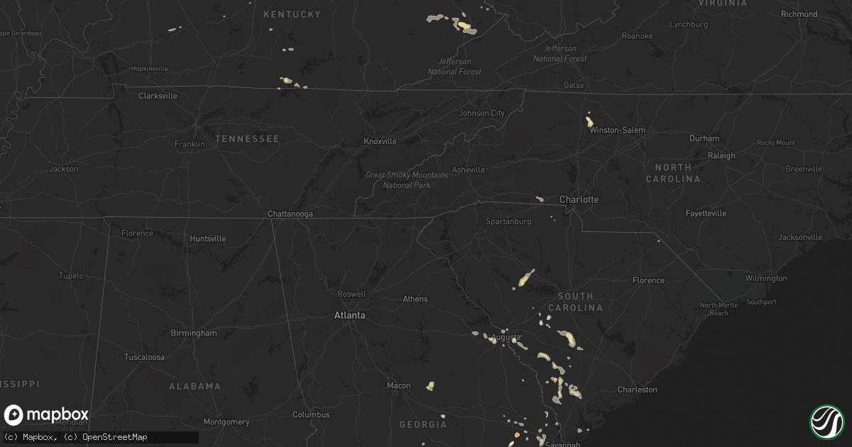
Hail Map in Kentucky on August 13, 2011
Get this storm
August 13 map
$229
one time, instant access
Download today. No call, no setup
Keep the $229
Bought the map and want the full workflow? Apply the entire $229 to a subscription within 7 days. None of it is wasted.
Every map, not just this one
This buys you this map. Subscription and you get every map we run, in the markets you choose from a few cities to whole states to nationwide. Plus real-time alerts the moment a storm fires.
Contact data
Name, contact info, occupancy, even credit band for addresses in the footprint. You go from where it hit to who to call.
Become the source they trust
Unlimited branding weather history reports on demand. You already have the documented answer ready for the property owner, and you are the one who showed up with it.
Property data and RoofTrace estimates
Pull up any address you have got, its value and the exact code rules for that jurisdiction, straight from One Click Code. Then RoofTrace estimates the squares, pitch, and roof value, priced the way you price.
Storm reports in Kentucky
Kentucky
| Date | Description |
|---|---|
| 08/13/20116:45 PM CDT | The county road foreman reported numerous trees downed and blocking roads around the county. |
| 08/13/20116:36 PM CDT | Trees down throughout bourbon county. Power was out across the paris area for two hours. |
| 08/13/20116:31 PM CDT | Several trees blocking hwy 62 between leesburg and cynthiana |
| 08/13/20116:26 PM CDT | Report of numerous trees down as well as a power pole snapped in half |
| 08/13/20116:17 PM CDT | Local law emforcement reports several trees down along newtown pike near lemons mill road. |
| 08/13/20116:15 PM CDT | Dispatch reports multiple trees and power lines down across the city |
| 08/13/20116:12 PM CDT | Local law enforcement reports several trees down along paynes depot road near mcclelland circle. |
| 08/13/20116:08 PM CDT | Local law enforcement reports several trees down along stamping ground road near white oak road. |
| 08/13/20116:00 PM CDT | Several trees blocking hwy 62 at midway |
| 08/13/20115:56 PM CDT | Report of numerous trees... Tree limbs... And power lines down across much of franklin county including house fires |
| 08/13/20115:54 PM CDT | Tree reported down along lucas lane |
| 08/13/20115:54 PM CDT | Report of trees snapped and down near peaks mill |
| 08/13/20115:50 PM CDT | Trees and tree limbs reported down as well as loss of power near the intersection of owenton rd. And royal pkwy. |
| 08/13/20115:49 PM CDT | Downed power line near the intersection of aztec trail and schenkel lane |
| 08/13/20115:38 PM CDT | Trees down on christiansburg road near cropper and bagdad |
| 08/13/20115:31 PM CDT | A local report indicates 60 MPH wind near 3 E SHELBYVILLE |
| 08/13/20115:28 PM CDT | At wal mart |
| 08/13/20115:26 PM CDT | Dispatch reports trees and tree limbs down across the area |
| 08/13/20115:24 PM CDT | Estimated 60 mph winds along with 1 inch hail |
| 08/13/20115:23 PM CDT | Estimated 60 mph winds along with 1 inch hail |
| 08/13/20115:10 PM CDT | Power lines down along the oldham-jefferson county line |
| 08/13/20115:10 PM CDT | Numerous trees down in simpsonville and todds point areas |
| 08/13/20115:05 PM CDT | Tree approx. 12 inches in diameter snapped at the trunk... Spotter estimates 65 mph winds |
| 08/13/20115:02 PM CDT | I-64 at blankenbaker pkwy is blocked in both directions due to a power line across the road |
| 08/13/20115:01 PM CDT | A local report indicates 65 MPH wind near ANCHORAGE |
| 08/13/20115:00 PM CDT | A local report indicates 64 MPH wind near 1 S LOUISVILLE |
| 08/13/20115:00 PM CDT | Mesonet reports 58.7 mph wind gust |
| 08/13/20114:59 PM CDT | Tree limbs reported down in the douglass hills and middletown areas along shelbyville rd. |
| 08/13/20114:58 PM CDT | Multiple trees reported down near the hurstbourne grand apartments including one that fell on a vehicle |
| 08/13/20114:58 PM CDT | Small tree limbs reported down |
| 08/13/20114:58 PM CDT | Tree down on a house in hikes point. 60 mph winds estimated. |
| 08/13/20114:57 PM CDT | Recorded by asos at louisville bowman field |
| 08/13/20114:57 PM CDT | Recorded by asos at louisville bowman field |
| 08/13/20114:56 PM CDT | Tree fell on house |
| 08/13/20114:56 PM CDT | Numerous large limbs and power lines down near the intersection of breckenridge ln. And norbourne blvd. |
| 08/13/20114:55 PM CDT | A cessna airplane overturned onto another aircraft at bowman filed. Siding blew off the air traffic control tower. |
| 08/13/20114:55 PM CDT | A cessna airplane overturned onto another aircraft at bowman filed. Siding blew off the air traffic control tower. |
| 08/13/20114:55 PM CDT | Tree limbs reported down... Spotter estimated winds of 50 mph |
| 08/13/20114:49 PM CDT | Trees down near the intersection of baxter ave. And grinstead dr. |
| 08/13/20114:44 PM CDT | Trees down near the intersection of baxter ave. And grinstead dr. |
| 08/13/20114:43 PM CDT | Mature trees toppled in numerous blocks of the highlands...crescent hill... And audubon park. |
| 08/13/20114:43 PM CDT | Numerous trees and power lines down in the shively area |
| 08/13/20114:41 PM CDT | Closed roads due to debris and downed power lines at 34th street at broadway |
| 08/13/20114:41 PM CDT | Power lines on a roof at crums and burrell |
| 08/13/20114:39 PM CDT | Power lines down at dixie hwy and i-264 |
| 08/12/201110:00 PM CDT | State police report one tree down blocking newsome cemetery road. |
| 08/12/20117:08 PM CDT | Report of tree and power lines down |
All States Impacted by Hail Map on August 13, 2011
Cities Impacted by Hail Map on August 13, 2011
- Knox, IN
- La Crosse, IN
- Hanna, IN
- Lafayette, IN
- Dayton, IN
- Rochester, IN
- Kewanna, IN
- Boonville, NC
- Yadkinville, NC
- Grant, CO
- Yermo, CA
- Clayhole, KY
- Jackson, KY
- Gunlock, KY
- Vest, KY
- Valparaiso, IN
- Spencer, IN
- Freedom, IN
- Genoa, IL
- Raton, NM
- Gilman, IL
- Ellery, IL
- Golden Gate, IL
- Palatine, IL
- Arlington Heights, IL
- Buffalo Grove, IL
- Lake Zurich, IL
- Walker, WV
- Augusta, GA
- Leesville, SC
- Wagener, SC
- Pelion, SC
- Inwood, WV
- Martinsburg, WV
- Hedgesville, WV
- Gerrardstown, WV
- Eckerty, IN
- Birdseye, IN
- Elizabeth, PA
- Mckeesport, PA
- Clairton, PA
- Canton, IL
- Glasford, IL
- Greencastle, IN
- Cloverdale, IN
- Onarga, IL
- Crescent City, IL
- Odell, IL
- Mount Pulaski, IL
- Lincoln, IL
- Elkhart, IL
- New Holland, IL
- Middletown, IL
- Hilton Head Island, SC
- Bluffton, SC
- Solsberry, IN
- Bloomington, IN
- Marathon, TX
- Mount Olive, IL
- Litchfield, IL
- Walshville, IL
- Lombard, IL
- Glen Ellyn, IL
- Hoopeston, IL
- Milford, IL
- Wellington, IL
- Jackson, SC
- Aiken, SC
- West Lafayette, IN
- Fort Stockton, TX
- Barrington, IL
- Beloit, WI
- Janesville, WI
- Orfordville, WI
- Lebanon Junction, KY
- Boston, KY
- Claxton, GA
- Fowler, IN
- Ambia, IN
- Oxford, IN
- Pine Village, IN
- Boswell, IN
- Templeton, IN
- Cynthiana, KY
- Berry, KY
- Rockford, IL
- Jeffersonville, IN
- Clarksville, IN
- Sellersburg, IN
- Onondaga, MI
- Parma, MI
- Rives Junction, MI
- Clifton, IL
- Ashkum, IL
- Woodridge, IL
- Virgie, KY
- Beaver, KY
- Teaberry, KY
- Robinson Creek, KY
- McDowell, KY
- Pikeville, KY
- Betsy Layne, KY
- Harold, KY
- Ocala, FL
- Waverly, IL
- Jacksonville, IL
- Franklin, IL
- Pontiac, IL
- Flanagan, IL
- Graymont, IL
- Mountain Top, PA
- Nescopeck, PA
- Berwick, PA
- Wapwallopen, PA
- Mifflinville, PA
- Drums, PA
- Bloomsburg, PA
- Sugarloaf, PA
- Buchanan, MI
- Niles, MI
- Galien, MI
- Sparta, MI
- Conklin, MI
- De Land, IL
- Clinton, IL
- Weldon, IL
- Early Branch, SC
- Yemassee, SC
- Pembroke, GA
- Portage, IN
- Merrillville, IN
- Gary, IN
- Hobart, IN
- Bloomington, IL
- Forreston, IL
- Polo, IL
- Lowell, IN
- Crown Point, IN
- Wilmington, IL
- Elwood, IL
- Manhattan, IL
- Anderson, IN
- Middletown, IN
- Markleville, IN
- Pendleton, IN
- Model, CO
- Leland, IL
- Berne, IN
- Bluffton, IN
- Geneva, IN
- Monroe, IN
- Trinidad, CO
- Weston, CO
- Deputy, IN
- Madison, IN
- Chebanse, IL
- Herscher, IL
- Buckingham, IL
- Cabery, IL
- Burkesville, KY
- Cullom, IL
- Lawton, MI
- Mcconnelsville, OH
- Cumberland, OH
- Blue Rock, OH
- Kimbolton, OH
- Newcomerstown, OH
- Waverly, WV
- Rincon, GA
- Hidalgo, IL
- Newton, IL
- Latham, IL
- Warrensburg, IL
- Metamora, IL
- Grovetown, GA
- Aurora, IL
- Naperville, IL
- Hartsburg, IL
- Atlanta, IL
- Emden, IL
- Centertown, KY
- Central City, KY
- Woodstock, IL
- Schnellville, IN
- Dubois, IN
- Saint Anthony, IN
- Jasper, IN
- Celestine, IN
- Ivesdale, IL
- Yorkville, IL
- Bolingbrook, IL
- Plainfield, IL
- Oswego, IL
- La Porte, IN
- Huntingburg, IN
- Loami, IL
- Winchester, IL
- Weirsdale, FL
- Lady Lake, FL
- Ocklawaha, FL
- Summerfield, FL
- Mumford, NY
- Caledonia, NY
- Scottsville, NY
- Oconto, NE
- Callaway, NE
- Byron Center, MI
- Hudsonville, MI
- Decatur, IN
- Lanark, IL
- San Jose, IL
- Mason City, IL
- Moweaqua, IL
- Bethany, IL
- Smithfield, KY
- Eminence, KY
- Paris Crossing, IN
- Lexington, IN
- Commiskey, IN
- Hanover, IN
- Cisco, IL
- Charlotte, MI
- Vermontville, MI
- Mulliken, MI
- Shannon, IL
- Ashland, IL
- Virginia, IL
- Arenzville, IL
- Grandfalls, TX
- Dryden, TX
- McLean, IL
- Mount Morris, IL
- Pearl City, IL
- Rochelle, IL
- Oregon, IL
- Chana, IL
- Mount Carroll, IL
- Easton, IL
- Kilbourne, IL
- Havana, IL
- Fruitland Park, FL
- Rossville, IN
- Dunkirk, IN
- Michigan City, IN
- Chesterton, IN
- Decker, IN
- Mount Carmel, IL
- Mapleton, IL
- Pekin, IL
- Peoria, IL
- Farmer City, IL
- Dwight, IL
- Grand Rapids, MI
- Grandville, MI
- Jenison, MI
- Alapaha, GA
- Nashville, GA
- Rockbridge, IL
- Monon, IN
- Winamac, IN
- Monticello, IN
- Buffalo, IN
- Star City, IN
- Francesville, IN
- Monticello, IL
- Sheridan, IL
- Sandwich, IL
- Newark, IL
- Shepherdsville, KY
- Ashton, IL
- Steward, IL
- Elfrida, AZ
- Marseilles, IL
- Wabash, IN
- Urbana, IN
- Otterbein, IN
- Isonville, KY
- Ellabell, GA
- Carbon, IN
- Rosedale, IN
- Ontario, NY
- Macedon, NY
- Walworth, NY
- Chesterfield, IL
- Carlinville, IL
- Waterman, IL
- Folkston, GA
- Shipman, IL
- Gillespie, IL
- Saint Meinrad, IN
- Saint Croix, IN
- Tell City, IN
- Bristow, IN
- Branchville, IN
- Ferdinand, IN
- New Castle, IN
- Chicago, IL
- Park Ridge, IL
- Harwood Heights, IL
- Schiller Park, IL
- Bensenville, IL
- Des Plaines, IL
- Minonk, IL
- Hebron, IN
- Vandalia, IL
- Pleasant Plains, IL
- Springfield, IL
- Sylvania, GA
- Scotts, MI
- Yale, IL
- Eddyville, NE
- Sumner, NE
- Columbia, KY
- Irwinton, GA
- Toomsboro, GA
- McIntyre, GA
- East Leroy, MI
- Vicksburg, MI
- Climax, MI
- Fulton, MI
- Petersburg, WV
- Durand, IL
- Fisherville, KY
- Louisville, KY
- Simpsonville, KY
- Lisle, IL
- Downers Grove, IL
- Washburn, IL
- Toluca, IL
- Farmington, MI
- Novi, MI
- Sierra Blanca, TX
- Broken Bow, NE
- Switz City, IN
- Linton, IN
- Rockford, MI
- Sugar Grove, IL
- Big Rock, IL
- Hawthorne, FL
- Fort McCoy, FL
- Citra, FL
- Interlachen, FL
- McNabb, IL
- Lostant, IL
- Leaf River, IL
- Jewett, IL
- Burlington, WI
- Genoa City, WI
- Newaygo, MI
- Grant, MI
- Uhrichsville, OH
- Battle Creek, MI
- Marshall, MI
- Ceresco, MI
- Burlington, MI
- Farmersville, IL
- Divernon, IL
- Virden, IL
- Algonquin, IL
- Fox River Grove, IL
- Palatka, FL
- Satsuma, FL
- Jefferson, CO
- Bailey, CO
- Le Roy, IL
- Mount Olivet, KY
- Silex, MO
- Lake Station, IN
- Schererville, IN
- Greenview, IL
- Athens, IL
- White Oak, GA
- Polk City, FL
- Gregory, MI
- Chelsea, MI
- Dexter, MI
- Summit Argo, IL
- La Grange, IL
- Clarendon Hills, IL
- Justice, IL
- Bridgeview, IL
- Hinsdale, IL
- Willowbrook, IL
- Western Springs, IL
- Westmont, IL
- Darien, IL
- Demotte, IN
- Shelby, IN
- Saluda, SC
- Silverstreet, SC
- Newberry, SC
- Walsenburg, CO
- Maroa, IL
- Rush, NY
- Brooklet, GA
- Tremont, IL
- Mackinaw, IL
- Roanoke, IN
- South Lyon, MI
- Whitmore Lake, MI
- Pinckney, MI
- Brighton, MI
- Hamburg, MI
- Dekalb, IL
- Malta, IL
- Paris, IL
- Redmon, IL
- Brocton, IL
- Rankin, IL
- Cissna Park, IL
- Armington, IL
- Hardy, KY
- Stone, KY
- Morris, IL
- Davis Junction, IL
- Corning, OH
- Crooksville, OH
- Minooka, IL
- Cary, IL
- Findlay, IL
- Sullivan, IL
- Windsor, IL
- Peotone, IL
- Putnam, IL
- Fremont, MI
- Georgetown, KY
- Stamping Ground, KY
- Ada, MI
- Lowell, MI
- Belmont, MI
- Casnovia, MI
- Woodbine, GA
- Waverly, GA
- Milledgeville, IL
- Brazil, IN
- Reelsville, IN
- Waynesville, IL
- Beason, IL
- Wapella, IL
- Kenney, IL
- Long Point, IL
- Cornell, IL
- Pecatonica, IL
- Rochester, NY
- Mulberry Grove, IL
- Saunemin, IL
- Springfield, GA
- Clyo, GA
- Hamlet, IN
- Albion, IL
- McColl, SC
- English, IN
- Grantsburg, IN
- Marengo, IN
- Taswell, IN
- North Augusta, SC
- Somonauk, IL
- Bardstown, KY
- Cordova, SC
- Cope, SC
- Orangeburg, SC
- Browns, IL
- Evansville, IN
- Owensville, IN
- Haubstadt, IN
- Grayville, IL
- Poseyville, IN
- Griffin, IN
- Wadesville, IN
- New Harmony, IN
- Cynthiana, IN
- Shortsville, NY
- Farmington, NY
- Canandaigua, NY
- Victor, NY
- Bloomfield, NY
- Beech Island, SC
- Salley, SC
- Colfax, IL
- Howard City, MI
- Lake In The Hills, IL
- Carpentersville, IL
- Register, GA
- Metter, GA
- Augusta, MO
- Defiance, MO
- Marthasville, MO
- Grant Park, IL
- South Haven, MI
- Covert, MI
- Ransom, IL
- Roanoke, IL
- Lowpoint, IL
- Jupiter, FL
- Loxahatchee, FL
- West Palm Beach, FL
- Groveland, IL
- Manito, IL
- Skokie, IL
- Evanston, IL
- Sheldon, IL
- Martinton, IL
- Emington, IL
- Watseka, IL
- Kempton, IL
- Webster, NY
- Doerun, GA
- Trinchera, CO
- Tampa, FL
- Jamestown, TN
- Georgetown, IN
- Floyds Knobs, IN
- Fort Lauderdale, FL
- Shabbona, IL
- Hinckley, IL
- Streator, IL
- Rutland, IL
- Dana, IL
- Cedar Lake, IN
- Three Rivers, MI
- Paris, KY
- Varnville, SC
- Estill, SC
- Pineland, SC
- Ulmer, SC
- Donnellson, IL
- Fairport, NY
- Chestnut, IL
- Hephzibah, GA
- Bloomingdale, GA
- Winfield, IL
- West Chicago, IL
- Rentz, GA
- Dublin, GA
- Frankfort, KY
- Elkton, FL
- Dowagiac, MI
- Delphi, IN
- Battle Ground, IN
- Burton, WV
- Holbrook, PA
- Spraggs, PA
- Wana, WV
- New Freeport, PA
- Portland, IN
- Hennepin, IL
- Pawnee, IL
- Spencerville, OH
- Venedocia, OH
- Rockford, OH
- Mendon, OH
- Immokalee, FL
- Fithian, IL
- Marion, NY
- Palmyra, NY
- West Henrietta, NY
- Lizton, IN
- Waterford, WI
- Celina, TN
- Seneca, IL
- Mendon, MI
- Alma, IL
- Salem, IL
- Brunson, SC
- Fairfax, SC
- Leslie, MI
- Westcliffe, CO
- Stanford, IL
- Mchenry, IL
- Cannelton, IN
- Derby, IN
- Union Star, KY
- Sigel, IL
- Norman Park, GA
- Comstock Park, MI
- Kent City, MI
- Twelve Mile, IN
- Lucerne, IN
- Fairfield, IL
- Cisne, IL
- Decatur, IL
- McArthur, OH
- Frankfort, IN
- Cutler, IN
- Barnwell, SC
- Harlem, GA
- Appling, GA
- Varna, IL
- Richmond, IL
- Hebron, IL
- Hesperia, MI
- Deltona, FL
- Lake Helen, FL
- Muncie, IN
- Winslow, IN
- Dansville, NY
- Eaton Rapids, MI
- Olivet, MI
- Albion, MI
- Springport, MI
- Coopersville, MI
- Cedar Springs, MI
- Marne, MI
- Leitchfield, KY
- Wauconda, IL
- Bloomfield, IN
- West Lafayette, OH
- Plainfield, OH
- Fresno, OH
- Port Washington, OH
- Coshocton, OH
- Marcellus, MI
- Jones, MI
- Eighty Four, PA
- Finleyville, PA
- Bentleyville, PA
- Plano, IL
- Crestwood, KY
- Wyoming, MI
- Kingsland, GA
- Royal Center, IN
- Daleville, IN
- East Troy, WI
- Elkhorn, WI
- The Villages, FL
- Wildwood, FL
- Neeses, SC
- Hoffman Estates, IL
- Elgin, IL
- Williamson, NY
- Penfield, NY
- Honeoye, NY
- Preston, MD
- Trappe, MD
- Ridott, IL
- Rome, IN
- Daggett, CA
- Olar, SC
- Ehrhardt, SC
- Alexandria, IN
- Frankton, IN
- Chrisman, IL
- Ridge Farm, IL
- Union Grove, WI
- Sturtevant, WI
- Kennard, IN
- Shirley, IN
- Owaneco, IL
- Taylorville, IL
- Gibson City, IL
- New Matamoras, OH
- Graysville, OH
- Brunswick, GA
- Townsend, GA
- Darien, GA
- Joliet, IL
- Channahon, IL
- Kingston Mines, IL
- Morton, IL
- Danvers, IL
- Georgetown, IL
- Indianola, IL
- Catlin, IL
- Stephensport, KY
- Hardinsburg, KY
- Lebanon, IN
- Summersville, KY
- York, SC
- Garnett, SC
- Hampton, SC
- Jeromesville, OH
- Springwater, NY
- New Concord, OH
- Jackson, MI
- Howell, MI
- Glendale Heights, IL
- Bloomingdale, IL
- Heltonville, IN
- Bedford, IN
- Kings Mountain, NC
- Fairbury, IL
- Forrest, IL
- Piper City, IL
- Chatsworth, IL
- Bunnell, FL
- East Palatka, FL
- Hastings, FL
- Edinburg, IL
- Rochester, IL
- Thomson, GA
- White Cloud, MI
- Manchester, MD
- Hampstead, MD
- Geff, IL
- Beardstown, IL
- Chatham, IL
- Clayton, IN
- Eastman, GA
- Rhine, GA
- Neoga, IL
- Mattoon, IL
- Deland, FL
- New Berlin, IL
- Albany, KY
- Kalamazoo, MI
- Paw Paw, MI
- Portage, MI
- Mattawan, MI
- Serena, IL
- Downs, IL
- Normal, IL
- Pleasureville, KY
- Montezuma, IN
- Hillsdale, IN
- West Finley, PA
- Malta, OH
- River Grove, IL
- Franklin Park, IL
- Maywood, IL
- Melrose Park, IL
- Elmwood Park, IL
- River Forest, IL
- Sterling, IL
- Woosung, IL
- Dixon, IL
- Franklin Grove, IL
- Itasca, IL
- Wood Dale, IL
- Mundelein, IL
- Island Lake, IL
- Grayslake, IL
- Plymouth, MI
- Branchville, SC
- North Judson, IN
- Grovertown, IN
- Wanatah, IN
- Allons, TN
- North Manchester, IN
- Lakeland, FL
- Auburndale, FL
- Grover, NC
- Shelby, NC
- Sarahsville, OH
- Summerfield, OH
- Senecaville, OH
- Quaker City, OH
- Grand Ledge, MI
- Sorrento, FL
- Bloomingdale, IN
- Clinton, IN
- Bryant, IN
- Springville, IN
- Owensburg, IN
- Cutler, IL
- Pittsford, NY
- Henrietta, NY
- Reddick, IL
- Kenosha, WI
- Edwardsburg, MI
- Cassopolis, MI
- Ypsilanti, MI
- Kouts, IN
- Pecos, TX
- Argenta, IL
- Vandalia, MI
- Apopka, FL
- Fitzgerald, GA
- Constantine, MI
- Guyton, GA
- Lake George, CO
- Saint Augustine, FL
- Dana, IN
- Cayuga, IN
- Nashville, MI
- Belfry, KY
- Canada, KY
- Sidney, KY
- Coldwater, OH
- Fort Recovery, OH
- Celina, OH
- Bagdad, KY
- Pall Mall, TN
- Galesburg, MI
- Coal City, IL
- Verona, IL
- Pana, IL
- Dobson, NC
- Green Cove Springs, FL
- Osteen, FL
- Montgomery, IL
- Bristol, IL
- Millington, IL
- Danville, IL
- Cherry Valley, IL
- Belvidere, IL
- Land O'Lakes, FL
- Gays, IL
- Statesboro, GA
- Batesburg, SC
- Bellevue, MI
- Garrett, KY
- Grethel, KY
- Weeksbury, KY
- Dema, KY
- Minnie, KY
- Bypro, KY
- Langley, KY
- Drift, KY
- Melvin, KY
- Topmost, KY
- Lackey, KY
- Bevinsville, KY
- Hi Hat, KY
- Wheelwright, KY
- Sandy Hook, KY
- Lodge, SC
- Medora, IL
- Petersburg, IN
- Hazleton, IN
- Glennville, GA
- Mineral Point, WI
- White Sands Missile Range, NM
- Milltown, IN
- Depauw, IN
- Bushnell, FL
- Michigantown, IN
- Shelbiana, KY
- Elkhorn City, KY
- Hellier, KY
- Jenkins, KY
- Paoli, IN
- Hardinsburg, IN
- Masonic Home, KY
- Fort Pierce, FL
- Hueysville, KY
- Chiefland, FL
- Marengo, IL
- Earlville, IL
- Stillman Valley, IL
- Byron, IL
- Byrdstown, TN
- Wesley Chapel, FL
- Welaka, FL
- Grand Junction, MI
- West Liberty, KY
- Danforth, IL
- Bainbridge, IN
- Thawville, IL
- Dyer, IN
- Crete, IL
- Beecher, IL
- Bamberg, SC
- Lapel, IN
- Earl Park, IN
- Minier, IL
- Hopedale, IL
- Kincaid, IL
- Rebecca, GA
- Chappells, SC
- Kirkland, IL
- Monroe Center, IL
- Canton, MI
- Shelbyville, KY
- Oreana, IL
- Schaumburg, IL
- Rolling Meadows, IL
- Winnebago, IL
- Bangor, MI
- Midway, KY
- Lexington, KY
- Oakland, IL
- Churchville, NY
- Brookston, IN
- Norway, SC
- Ottawa, IL
- Moorefield, WV
- Payneville, KY
- Fennville, MI
- Pullman, MI
- Alexander, IL
- Livonia, NY
- Lima, NY
- Hemlock, NY
- Nicholls, GA
- Southfield, MI
- Franklin, MI
- Cecilia, KY
- Kentland, IN
- Munith, MI
- Northville, MI
- Livonia, MI
- Hamburg, AR
- Odin, IL
- Patoka, IL
- Huntsville, AL


