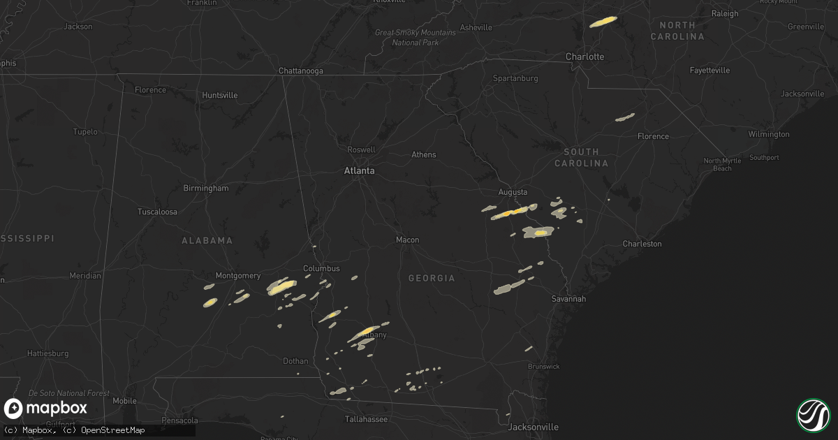
Hail Map in Alabama on November 16, 2011
Get this storm
November 16 map
$229
one time, instant access
Download today. No call, no setup
Keep the $229
Bought the map and want the full workflow? Apply the entire $229 to a subscription within 7 days. None of it is wasted.
Every map, not just this one
This buys you this map. Subscription and you get every map we run, in the markets you choose from a few cities to whole states to nationwide. Plus real-time alerts the moment a storm fires.
Contact data
Name, contact info, occupancy, even credit band for addresses in the footprint. You go from where it hit to who to call.
Become the source they trust
Unlimited branding weather history reports on demand. You already have the documented answer ready for the property owner, and you are the one who showed up with it.
Property data and RoofTrace estimates
Pull up any address you have got, its value and the exact code rules for that jurisdiction, straight from One Click Code. Then RoofTrace estimates the squares, pitch, and roof value, priced the way you price.
Storm reports in Alabama
Alabama
| Date | Description |
|---|---|
| 11/16/20112:55 PM CST | 1 tree down at 5832 old webb road. Delayed report from wednesday. |
| 11/16/20112:55 PM CST | 1 tree down at 102 5th avenue in ashford. Delayed report from wednesday. |
| 11/16/20112:55 PM CST | 1 tree down at 490 n state highway 95. Delayed report from wednesday. |
| 11/16/20112:50 PM CST | 1 tree down at 12901 e county road 8. Delayed report from wednesday. |
| 11/16/201112:35 PM CST | Several buildings and boathouses were damaged along lake harding |
| 11/16/201112:15 PM CST | Possible tornado. Major damage to trailer park. Trailers and vehicles totally demolished. |
| 11/16/201112:07 PM CST | Possible tornado. Significant damage at terrace acres apartment complex. |
| 11/16/201112:00 PM CST | Possible tornado. Building blown down. |
| 11/16/201111:52 AM CST | *** 1 inj *** an ef1 tornado with winds of 110 mph touched down in macon county and moved northeast into lee county crossing city of auburn and lake harding before movi |
| 11/16/201111:42 AM CST | Several trees were blown down in reeltown. |
| 11/16/201111:32 AM CST | Several trees were blown down near shorter. |
| 11/16/201111:27 AM CST | Several trees down across rigsby rd just south of rifle range rd. Possible tornado. |
| 11/16/201111:22 AM CST | Trees down on highway 97 after a strong circulation passed from southwest to northeast. |
| 11/16/201111:08 AM CST | An ef1 tornado touched at the alabama christian academy and knocked over a scoreboard and snapped a large pine tree. The tornado traveled northeast where several mobile |
| 11/16/201111:02 AM CST | Trees down in the cloverdale section of montgomery. Possible tornado. Time estimated from radar. |
| 11/16/201110:40 AM CST | Power outages reported in hayneville as well as several trees down across the county. |
| 11/16/20119:25 AM CST | Tree reported down on home in the northwest half of huntsville. A few power lines were also reported down. |
| 11/16/20119:17 AM CST | A johnson high school sign was blown down. This is located at cecil fain drive and winchester road in northwest huntsville. Time estimated. |
| 11/16/20119:15 AM CST | 65 mph wind gust estimated in the providence area |
| 11/16/20119:15 AM CST | 911 center in northwest huntsville. |
| 11/16/20119:15 AM CST | 65 mph wind gust estimated in the providence area |
| 11/16/20119:07 AM CST | Trees and power lines down from woody anderson ford to meridian street. |
| 11/16/20119:00 AM CST | One-quarter mile swath of 6 inch diameter young pine tree trucks snapped off about 5 feet above the ground. |
| 11/16/20117:35 AM CST | Structural roof damage reported in downtown demopolis. Also a boat was overturned at a boat dealership. |
| 11/16/20117:32 AM CST | An ef0 tornado touched down in demopolis along maria ave and lifted 2.57 miles to the northeast along us highway 80. Approx 20 homes sustained minor roof damage and sev |
| 11/16/20117:07 AM CST | *** 1 inj *** an ef2 tornado touched down along county road 42 and moved northeast for 1.50 miles. It snapped 150 softwoods and uprooted 50 hardwoods. Five outbuildings |
| 11/16/20117:04 AM CST | Sheriff office reports trees down and homes damaged from a possible tornoado in the whitfield area near county road 42 and state road 17. |
All States Impacted by Hail Map on November 16, 2011
Cities Impacted by Hail Map on November 16, 2011
- Bainbridge, GA
- Spencer, NC
- Mooresville, NC
- Linwood, NC
- Mount Ulla, NC
- China Grove, NC
- Salisbury, NC
- Cuthbert, GA
- Leesburg, GA
- Albany, GA
- Ramer, AL
- Whigham, GA
- Buena Vista, GA
- Quincy, FL
- Attapulgus, GA
- Blackville, SC
- Jackson, SC
- Louisville, GA
- Waynesboro, GA
- Keysville, GA
- Wrens, GA
- Hephzibah, GA
- Holly Hill, SC
- Quitman, GA
- Valdosta, GA
- Morven, GA
- Coleman, GA
- Denmark, SC
- Ulmer, SC
- Olar, SC
- Barnwell, SC
- Fort Deposit, AL
- Minter, AL
- Letohatchee, AL
- Forest Home, AL
- Bamberg, SC
- Adel, GA
- Midway, AL
- Sylvania, GA
- Omaha, GA
- Cusseta, GA
- Lodge, SC
- Ruffin, SC
- Smoaks, SC
- Fairfax, SC
- Girard, GA
- Sardis, GA
- Allendale, SC
- Martin, SC
- Millen, GA
- Union Springs, AL
- Tuskegee, AL
- Boston, GA
- Clayton, AL
- Saint George, GA
- Hurtsboro, AL
- Leary, GA
- Dawson, GA
- Camilla, GA
- Hortense, GA
- Brunswick, GA
- Eufaula, AL
- Lyons, GA
- Collins, GA
- Claxton, GA
- Reidsville, GA
- Lakeland, GA
- Nashville, GA
- Statesboro, GA
- Louisville, AL
- Banks, AL
- Oakfield, GA
- Warwick, GA
- Blakely, GA
- Brooklet, GA
- Williston, SC
- Morris, GA
- Lapine, AL
- Highland Home, AL
- Grady, AL
- Arlington, GA
- Damascus, GA
- Cottonwood, AL
- Newton, GA
- Moultrie, GA
- Pavo, GA
- Hayneville, AL
- Tyler, AL
- Lowndesboro, AL
- Fort Mitchell, AL
- Pittsview, AL
- Donalsonville, GA
- Clio, AL
- Weston, GA
- Parrott, GA
- Montgomery, AL
- Colquitt, GA
- Ray City, GA
- Bethune, SC
- McBee, SC
- Hartsville, SC
- Chipley, FL
- Register, GA
- Fort Davis, AL
- Hahira, GA
- Hatchechubbee, AL
- Seale, AL
- Matthews, GA
- Blythe, GA
- Stapleton, GA
- Brinson, GA
- Newington, GA
- Naylor, GA
- West Point, GA
- Hamilton, GA
- Cairo, GA
- Climax, GA


