Hail Map in North Carolina on November 16, 2011
Get this storm
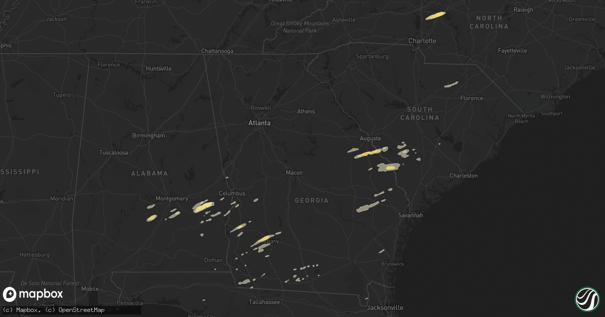
November 16 map
$229
one time, instant access
Download today. No call, no setup
Keep the $229
Bought the map and want the full workflow? Apply the entire $229 to a subscription within 7 days. None of it is wasted.
Every map, not just this one
This buys you this map. Subscription and you get every map we run, in the markets you choose from a few cities to whole states to nationwide. Plus real-time alerts the moment a storm fires.
Contact data
Name, contact info, occupancy, even credit band for addresses in the footprint. You go from where it hit to who to call.
Become the source they trust
Unlimited branding weather history reports on demand. You already have the documented answer ready for the property owner, and you are the one who showed up with it.
Property data and RoofTrace estimates
Pull up any address you have got, its value and the exact code rules for that jurisdiction, straight from One Click Code. Then RoofTrace estimates the squares, pitch, and roof value, priced the way you price.
Storm reports in North Carolina
North Carolina
| Date | Description |
|---|---|
| 11/16/20115:35 PM CST | Front of residence damaged... Vehicle blown into road... Walnut ridge road at morning glory road |
| 11/16/20115:30 PM CST | Trees down at intersection of north friendship rd and flat shoals rd |
| 11/16/20115:20 PM CST | Truck blown into road... Front of house blown off at fuller mill road and finch farm road |
| 11/16/20115:15 PM CST | Commerical buildings and homes damaged near the intersection of us 64 and route 109. Time estimated by radar. |
| 11/16/20115:14 PM CST | Trees down at 3500 hwy 704 west |
| 11/16/20115:11 PM CST | Trees down at 1346 va line rd |
| 11/16/20115:10 PM CST | Multiple homes damaged with people trapped inside near the 2600 block of young road. Time estimated by radar. |
| 11/16/20115:06 PM CST | Major structural damage to wood frame housing at sliver ridge and allred road |
| 11/16/20115:06 PM CST | Multiple homes destoyed on burkhart road. Time estimated by radar. |
| 11/16/20115:06 PM CST | Trees down 1946 hwy 704 east |
| 11/16/20115:06 PM CST | Trees down at 2687 flat rock rd |
| 11/16/20115:05 PM CST | Multiple trees and power lines down... Roof damage... At allred road and nc 47 |
| 11/16/20115:03 PM CST | Trees down at 2893 hart rd |
| 11/16/20115:02 PM CST | Trees down at hwy 704 and creasy rd. |
| 11/16/20115:01 PM CST | A local report indicates 1.75 inch wind near 4 N SALISBURY |
| 11/16/20114:52 PM CST | 1 hail near old salisbury road |
| 11/16/20114:46 PM CST | 1 tree reported down on vehicle just north of salisbury. |
| 11/15/201110:15 PM CST | Nws storm survey of an ef-0 tornado which tracked 1.6 miles. |
| 11/15/201110:07 PM CST | Two trees were uprooted just south of severn. Several road signs were also damaged. |
| 11/15/20117:55 PM CST | A large tree was reported down on stackhouse road. The time was estimated based on radar data. |
| 11/15/20117:55 PM CST | Large trees were reported down on progressive farm road. The time was estimated based on radar data. |
All States Impacted by Hail Map on November 16, 2011
Cities Impacted by Hail Map on November 16, 2011
- Bainbridge, GA
- Spencer, NC
- Mooresville, NC
- Linwood, NC
- Mount Ulla, NC
- China Grove, NC
- Salisbury, NC
- Cuthbert, GA
- Leesburg, GA
- Albany, GA
- Ramer, AL
- Whigham, GA
- Buena Vista, GA
- Quincy, FL
- Attapulgus, GA
- Blackville, SC
- Jackson, SC
- Louisville, GA
- Waynesboro, GA
- Keysville, GA
- Wrens, GA
- Hephzibah, GA
- Holly Hill, SC
- Quitman, GA
- Valdosta, GA
- Morven, GA
- Coleman, GA
- Denmark, SC
- Ulmer, SC
- Olar, SC
- Barnwell, SC
- Fort Deposit, AL
- Minter, AL
- Letohatchee, AL
- Forest Home, AL
- Bamberg, SC
- Adel, GA
- Midway, AL
- Sylvania, GA
- Omaha, GA
- Cusseta, GA
- Lodge, SC
- Ruffin, SC
- Smoaks, SC
- Fairfax, SC
- Girard, GA
- Sardis, GA
- Allendale, SC
- Martin, SC
- Millen, GA
- Union Springs, AL
- Tuskegee, AL
- Boston, GA
- Clayton, AL
- Saint George, GA
- Hurtsboro, AL
- Leary, GA
- Dawson, GA
- Camilla, GA
- Hortense, GA
- Brunswick, GA
- Eufaula, AL
- Lyons, GA
- Collins, GA
- Claxton, GA
- Reidsville, GA
- Lakeland, GA
- Nashville, GA
- Statesboro, GA
- Louisville, AL
- Banks, AL
- Oakfield, GA
- Warwick, GA
- Blakely, GA
- Brooklet, GA
- Williston, SC
- Morris, GA
- Lapine, AL
- Highland Home, AL
- Grady, AL
- Arlington, GA
- Damascus, GA
- Cottonwood, AL
- Newton, GA
- Moultrie, GA
- Pavo, GA
- Hayneville, AL
- Tyler, AL
- Lowndesboro, AL
- Fort Mitchell, AL
- Pittsview, AL
- Donalsonville, GA
- Clio, AL
- Weston, GA
- Parrott, GA
- Montgomery, AL
- Colquitt, GA
- Ray City, GA
- Bethune, SC
- McBee, SC
- Hartsville, SC
- Chipley, FL
- Register, GA
- Fort Davis, AL
- Hahira, GA
- Hatchechubbee, AL
- Seale, AL
- Matthews, GA
- Blythe, GA
- Stapleton, GA
- Brinson, GA
- Newington, GA
- Naylor, GA
- West Point, GA
- Hamilton, GA
- Cairo, GA
- Climax, GA


