Hail Map in South Carolina on November 16, 2011
Get this storm
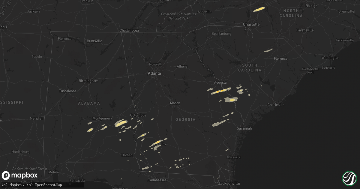
November 16 map
$229
one time, instant access
Download today. No call, no setup
Keep the $229
Bought the map and want the full workflow? Apply the entire $229 to a subscription within 7 days. None of it is wasted.
Every map, not just this one
This buys you this map. Subscription and you get every map we run, in the markets you choose from a few cities to whole states to nationwide. Plus real-time alerts the moment a storm fires.
Contact data
Name, contact info, occupancy, even credit band for addresses in the footprint. You go from where it hit to who to call.
Become the source they trust
Unlimited branding weather history reports on demand. You already have the documented answer ready for the property owner, and you are the one who showed up with it.
Property data and RoofTrace estimates
Pull up any address you have got, its value and the exact code rules for that jurisdiction, straight from One Click Code. Then RoofTrace estimates the squares, pitch, and roof value, priced the way you price.
Storm reports in South Carolina
South Carolina
| Date | Description |
|---|---|
| 11/16/20115:56 PM CST | Allendale county warning point reported numerous trees and power lines down on barton rd...citadel st...blanton rd. Time estimated by radar |
| 11/16/20115:52 PM CST | County sheriff reports trees down near olar. |
| 11/16/20115:43 PM CST | Sheriff office reported trees down in the cities of barnwell...hilda...and blackville. |
| 11/16/20114:41 PM CST | *** 3 fatal *** structural damage to 3 homes reported at highway 324 and williamson roads south of rock hill. 3 confirmed fatalities thus far. |
| 11/16/20114:06 PM CST | Swirling debris went across spotters house and blew shingles off his roof and knocked a tree down on the road. Winds estimated 50 mph plus. |
| 11/16/20114:06 PM CST | Tree reported on a vehicle on river rd near old ferry rd.also...neal shaols rd blocked with downed trees and power lines. |
| 11/16/20114:02 PM CST | County communications called to report additional damage observed near the intersection of neal shoals road and fairview church circle. A roof blown off a barn...power |
| 11/16/20113:21 PM CST | Laurens county sheriffs deputy observed a funnel cloud with possible debris. |
| 11/15/20117:54 PM CST | Used car dealership sign blown over damaging three cars. Time estimated based off radar. |
| 11/15/20117:27 PM CST | A large tree was reported down at the intersection of bartells road and old georgetown road. The time was estimated based on radar data. |
| 11/15/20117:20 PM CST | A large tree was reported down on cedar swamp road. The time was estimated based on radar data. |
| 11/15/20117:15 PM CST | A local report indicates 60 MPH wind near WILLIAMSBURG CTY ARPT |
| 11/15/20117:10 PM CST | A large tree was reported down on mcclam road. The time was estimated based on radar data. |
| 11/15/20117:10 PM CST | Trees down at intersection of sc hwy 6 and hampton street |
| 11/15/20117:00 PM CST | A large tree was reported down on manning highway. The time was estimated by radar data. |
| 11/15/20116:40 PM CST | Trees down at old river road and coveside circle |
| 11/15/20116:15 PM CST | Hampton county warning point reported 2 trees down on deer road. Time estimated by radar. |
| 11/15/20116:00 PM CST | Nws employee reported several trees down along highway 301. Time estimated by radar. |
All States Impacted by Hail Map on November 16, 2011
Cities Impacted by Hail Map on November 16, 2011
- Bainbridge, GA
- Spencer, NC
- Mooresville, NC
- Linwood, NC
- Mount Ulla, NC
- China Grove, NC
- Salisbury, NC
- Cuthbert, GA
- Leesburg, GA
- Albany, GA
- Ramer, AL
- Whigham, GA
- Buena Vista, GA
- Quincy, FL
- Attapulgus, GA
- Blackville, SC
- Jackson, SC
- Louisville, GA
- Waynesboro, GA
- Keysville, GA
- Wrens, GA
- Hephzibah, GA
- Holly Hill, SC
- Quitman, GA
- Valdosta, GA
- Morven, GA
- Coleman, GA
- Denmark, SC
- Ulmer, SC
- Olar, SC
- Barnwell, SC
- Fort Deposit, AL
- Minter, AL
- Letohatchee, AL
- Forest Home, AL
- Bamberg, SC
- Adel, GA
- Midway, AL
- Sylvania, GA
- Omaha, GA
- Cusseta, GA
- Lodge, SC
- Ruffin, SC
- Smoaks, SC
- Fairfax, SC
- Girard, GA
- Sardis, GA
- Allendale, SC
- Martin, SC
- Millen, GA
- Union Springs, AL
- Tuskegee, AL
- Boston, GA
- Clayton, AL
- Saint George, GA
- Hurtsboro, AL
- Leary, GA
- Dawson, GA
- Camilla, GA
- Hortense, GA
- Brunswick, GA
- Eufaula, AL
- Lyons, GA
- Collins, GA
- Claxton, GA
- Reidsville, GA
- Lakeland, GA
- Nashville, GA
- Statesboro, GA
- Louisville, AL
- Banks, AL
- Oakfield, GA
- Warwick, GA
- Blakely, GA
- Brooklet, GA
- Williston, SC
- Morris, GA
- Lapine, AL
- Highland Home, AL
- Grady, AL
- Arlington, GA
- Damascus, GA
- Cottonwood, AL
- Newton, GA
- Moultrie, GA
- Pavo, GA
- Hayneville, AL
- Tyler, AL
- Lowndesboro, AL
- Fort Mitchell, AL
- Pittsview, AL
- Donalsonville, GA
- Clio, AL
- Weston, GA
- Parrott, GA
- Montgomery, AL
- Colquitt, GA
- Ray City, GA
- Bethune, SC
- McBee, SC
- Hartsville, SC
- Chipley, FL
- Register, GA
- Fort Davis, AL
- Hahira, GA
- Hatchechubbee, AL
- Seale, AL
- Matthews, GA
- Blythe, GA
- Stapleton, GA
- Brinson, GA
- Newington, GA
- Naylor, GA
- West Point, GA
- Hamilton, GA
- Cairo, GA
- Climax, GA


